News   Jul 22, 2024
 563     0 
News   Jul 22, 2024
 1.6K     0 
News   Jul 22, 2024
 624     0 

The University line

I know it was meant to provide easy commute for financial district, but I just don't see the point of two parallel lines being 550 meters apart. I know many working on east side of University (MARS for example) simply get off the Yonge line (College St) and walk to office, instead of wasting 10 more minutes to make a U-turn.

What benefit is it to the TTC if they took the U-turn? The goal is to get people to where they want to go and for most people that isn't Spadina. The people on the University-Spadina line coming south going to the financial district don't benefit from going the long way to the financial district and the people who avoid the overcrowding of the Yonge line by transferring at St.George don't benefit either.
 
Ummm no. The "vibrant neighbourhoods" you are talking about were empty industrial wastelands for decades after the University line was built. When the University subway was built Chinatown wasn't even on Spadina. It was clustered around St. Patrick station.

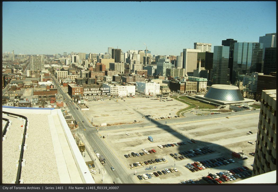
Here's a pic of the "vibrant" King West a decade after the subway opened. How it became a vibrant neighbourhood 30 years later has nothing to do with subways or transportation planning at all. It was due to marco economic trends and a rare instance of insight in our elected leaders.


Claiming things would have turned out better today if something was done different 50 years ago is stupid. Leave playing master of temporal causality to the experts.

Wow!!! It's difficult to just orient myself in that photo, it's so strange to what's there today. I'm assuming the Ed's World Famous Restaurant sign is along King West and the GIANT parking lot in the mid-ground of the photo is the future meto centre towers? Meaning the street running North South is John?
 
that being said, it is still a good idea to extend the Spadina line southward below Bloor, and make 4 stops at College, Dundas, Queen, King, and merge with the DRL at Lower Spadina Station.

Even if it's slower, the fact of the revived Spadina streetcar makes that notion redundant.

On the whole, we must remember that the University line routing was controversial in its day--even then, there were transit experts asserting that Spadina/Bathurst was preferrable, on grounds not unlike kkgg7--and for its first 15 years or so, it was white-elephantish enough to be closed on Sundays (a practice rescinded with the Spadina extension in 1978). These days, it may still be an imperfect circumstance, but it's all water under the bridge...
 
Ummm no. The "vibrant neighbourhoods" you are talking about were empty industrial wastelands for decades after the University line was built. When the University subway was built Chinatown wasn't even on Spadina. It was clustered around St. Patrick station.

Here's a pic of the "vibrant" King West a decade after the subway opened. How it became a vibrant neighbourhood 30 years later has nothing to do with subways or transportation planning at all. It was due to marco economic trends and a rare instance of insight in our elected leaders.

john.jpg


Claiming things would have turned out better today if something was done different 50 years ago is stupid. Leave playing master of temporal causality to the experts.

endgame1.jpg

wow, unbelievable. What is the street that seems to the edge of the buildings and city life in this photo? I suppose it is Front st? and the left most street is Spadina?
 
Even if it's slower, the fact of the revived Spadina streetcar makes that notion redundant.

On the whole, we must remember that the University line routing was controversial in its day--even then, there were transit experts asserting that Spadina/Bathurst was preferrable, on grounds not unlike kkgg7--and for its first 15 years or so, it was white-elephantish enough to be closed on Sundays (a practice rescinded with the Spadina extension in 1978). These days, it may still be an imperfect circumstance, but it's all water under the bridge...

I see.
I tend to overestimate the size of Toronto 20 or 30 years ago and assume it has always been a fairly large city when instead it was much smaller back then. I would guess back in the 80s, anything west of Spadina or east of Yonge is basically semi-suburban. Even today, although Bathurst St (and Jarvis St) are technically "downtown core", I find very little commercial activities and they are almost purely residential.

I have a friend who still claims anything north of Wellesley is "uptown" and north of St Clair is basically no one's land devoid of anything worth seeing or doing.

On the other hand, I am impressed by the rapid growth of Toronto during the past few decades. It is still rather small in my opinion as I am from a city of a much much larger size, but I'd love to see how the city grow going forward.
 
I just wanted to add to the discussion of the University line's routing and how it was intended to be a reliever for the Yonge line as well as a part of the Bloor Danforth line. If there were ever a way to bring interlining back and eliminate or at least mitigate the "oh I don't know which level at Bay the next eastbound train is arriving at". Someone had proposed extending the Spadina line south of Bloor along Spadina than Dundas terminating at Dundas station.

That would be great situation IMHO as it gives riders from the Northwest a one seat ride to the northern portion of the Downtown core as well as returning the main purpose of the University line (i.e. as a diversion of the B/D line bringing riders downtown)
 
i like the two lines so close together. it creates a border of where torontos center really is for highrises and commercial. i like that its close enough to get off one side be able to walk but end up in the other. Sometimes I think that a Subway from st clair west down bathurst across front and up to pape would be a good line. It would create a new border for density.
 
wow, unbelievable. What is the street that seems to the edge of the buildings and city life in this photo? I suppose it is Front st? and the left most street is Spadina?

Actually, that picture is 20 years after the University line opened. Roy Thomson Hall was completed in 1983. To the right of it, "the edge of the buildings and city life," is Simcoe. To the left, running past the vast vacant lots, is John. After that just a glimpse of Peter on the left and then Beverley near the top. No Spadina in the picture.
 
Last edited:
I don't see why there is even a debate here? I know not all of this existed at the time, but with UofT, Queen's Park, MaRS, the hospitals, insurance companies, and hotels, isn't it deserving? Spadina has nowhere near that many trip generators. Aside from Museum, these are some highly used stations:

St. Andrew (53,770)/King(60,270)
Osgoode(23,250)/Queen(58,710)
St. Patrick/Dundas(31,490)/Dundas(69,150)
Queen's Park (47,390)/College(49,340)

http://www3.ttc.ca/PDF/Transit_Planning/Subway ridership 2009-2010.pdf

well, your logic is flawed as you can't judge it just based on the seeming high ridership on these stations. How do you know if the line runs on Spadina, ridership won't be even higher? Chinatown, for example, is a main destination. I can see Spadina/Queen getting more traffic than Osgood as well.

I am one of those who often get off at Osgood or St Patrick, but those were almost never my destination. 95% of the time I transfer to a streetcar toward the west. So if these stations are placed on Spadina, the numbers likely hardly go lower, if not higher. Why would anyone go to University/Dundas as the destination, what is there other than a few hospitals? Dundas/Spadina on the other hand, is full of restaurants and shops.
 
Last edited:
i like the two lines so close together. it creates a border of where torontos center really is for highrises and commercial. i like that its close enough to get off one side be able to walk but end up in the other. Sometimes I think that a Subway from st clair west down bathurst across front and up to pape would be a good line. It would create a new border for density.

I like the line defining the city center as well, but just not as small as Yonge -Univeristy, which is simply too short (550M). Spadina is way more "commercial" than University. People hardly go to University Ave unless they work there. There is really nothing to do on most part of University Ave, unlike Spadina.

I like the St Clair, front, Bathust and Pape border idea as well. Maybe in 30 years, we can have a circle line like that.
 
Last edited:
I am one of those who often get off at Osgood or St Patrick, but those were almost never my destination. 95% of the time I transfer to a streetcar toward the west. So if these stations are placed on Spadina, the numbers likely hardly go lower, if not higher. Why would anyone go to University/Dundas as the destination, what is there other than a few hospitals? Dundas/Spadina on the other hand, is full of restaurants and shops.

You know, you could just get off at Spadina and take the streetcar.
The route you're asking for is right there!
 
I like the line defining the city center as well, but just not as small as Yonge -Univeristy, which is simply too short (550M). Spadina is way more "commercial" than University. People hardly go to University Ave unless they work there. There is really nothing to do on most part of University Ave, unlike Spadina.

I like the St Clair, front, Bathust and Pape border idea as well. Maybe in 30 years, we can have a circle line like that.

It's not 550 m. If we are saying that people could easily walk the distance between the two lines than we have to add 550 m to the east and west since people will also get off and walk the other direction as well. That makes the city center 1650 m wide and covers most of the densest part of the city. I know I'm splitting hairs a bit here but really now when the initial purpose of the line was to provide relief to yonge than it makes sense to have the lines closer together.

***Edit***

Furthermore there are destinations along University (or within walking distance) the ROM, House of Commons, Medical and government offices, theaters, etc. I guess it's just not as well known or promoted as it is on the Yonge side. For example, most people going to the Rogers center will get off at Union and walk along Bremner, however St. Andrew is just as quick.
 
Last edited:
It's not 550 m. If we are saying that people could easily walk the distance between the two lines than we have to add 550 m to the east and west since people will also get off and walk the other direction as well. That makes the city center 1650 m wide and covers most of the densest part of the city. I know I'm splitting hairs a bit here but really now when the initial purpose of the line was to provide relief to yonge than it makes sense to have the lines closer together.

***Edit***

Furthermore there are destinations along University (or within walking distance) the ROM, House of Commons, Medical and government offices, theaters, etc. I guess it's just not as well known or promoted as it is on the Yonge side. For example, most people going to the Rogers center will get off at Union and walk along Bremner, however St. Andrew is just as quick.

Regarding the 550 meters: that's exactly what I meant by saying the west branch should be on Spadina rather than University, as those who live close to Spadina or Bathurst (part of downtown, right?) can take advantage of it. Of course those who usually get on/off University are a bit worse off, but University is between Yonge and Spadina, a distance of 1400m. Anyone in between needs to walk a maximum of 700 meters to either Yonge or Spadina, which is completely acceptable for most people. In fact, less than that since there is no building in exactly the mid point. Someone at St Patrick st, for example, will walk 650 meter to Spadina, or 750 meter to Yonge.

In this way, you are covering a larger number of people from Bathust to Jarvis (2.6km). Right now, the convenience is reduced by the provilege of those who go to somewhere between University and Yonge as they can choose either University or Yonge line.

You are right about plenty of destination along University, however 1) Spadina is undoubtedly more commercial and has probably more foot traffic 2) It is not of the subway is taken away, there is no way to get there. For Christ's sake, the Yonge line is 550 meters away, take it and walk for 5 minute. It won't kill one for walking 5 minutes! Anyone outside downtown will be more than happy to walk 550 meters to a subway station.

as to serving the purpose of relieving Yonge line, the argument doesn't stand. A subway can't be used to serve to sole purpose of relieving another line. it should provide the maximum benefit. Plus, not everyone goes to Yonge st. Additionally, if that's the case, Bay Street is even close, why not on Bay? For a city like Toronto, subway can bring the crowds and business, and functions as a means to increase density and urban vibrancy. Do we really want a city that circles around one single street and all public transit and planning are made to bring people to that one street??
 
Last edited:
well, your logic is flawed as you can't judge it just based on the seeming high ridership on these stations. How do you know if the line runs on Spadina, ridership won't be even higher? Chinatown, for example, is a main destination. I can see Spadina/Queen getting more traffic than Osgood as well.

I am one of those who often get off at Osgood or St Patrick, but those were almost never my destination. 95% of the time I transfer to a streetcar toward the west. So if these stations are placed on Spadina, the numbers likely hardly go lower, if not higher.

If the line had been built along Spadina and it had become an institutional zone similar to what's now on University (somewhat unlikely given the employment related to Queen's Park, but possible), then sure. Chinatown is busy, but retail and residential just don't generate the same number of trips as big employers. The crowds of GO commuters taking the University line from union in the morning are mostly going to work at locations from Osgoode to St. George. I think people underestimate just how many people work in the "institutional zone" (UofT, hospitals, Queen's Park, MaRS, etc.). There are thousands of jobs in that area, which straddles the University line.

Why would anyone go to University/Dundas as the destination, what is there other than a few hospitals? Dundas/Spadina on the other hand, is full of restaurants and shops.

Those hospitals are HUGE employers, those office towers along University are also full of people, and the AGO and OCADU are just around the corner. Do you honestly think more people are getting off the subway to take the streetcar to grab a bowl of pho? Maybe on the weekend.
 

Back
Top