News   Jul 11, 2024
 267     0 
News   Jul 11, 2024
 410     0 
News   Jul 10, 2024
 655     0 

Roads: Ontario/GTA Highways Discussion

that would be interesting, but I wonder if it would be flooded by demand when it opened, as so many people would chose it as their preferred route. I would use it as well. the toll would be a good idea just to get the big shipping trucks off of it to keep speed moving as well.

here's my concept for the eastern GTA:

highway_zps537c60f0.jpg


Edit: missed the eastern branch of the 407 extension (407B?)
 
Last edited:
Traffic on highway 7 in the St. Mary's area seems to be in the 6000 vehicles per day range (AADT) - about the same as highway 69 north of Parry Sound.

So it is too low to justify a freeway.
It is too low based on those numbers. But most people driving from KW to London take the long way around on the 401. And even those that do go across country don't go through St. Mary's. most drop south at New Hamburg or Shakespeare. The AADT at St. Mary's isn't really indicated of current travel in that corridor, let alone the traffic you'd see if they actually built it.
 
I don't think a full grade-separate highway could ever be justified between London and Stratford, however with road tolls in place on the 401 and 402, I could see a full ring road being constructed around the north end of London if it were also tolled. I give you the 428:

5drloy.jpg


I've named it the 428 after Middlesex County Road 28 which it parallels in the north. To avoid too much disruption, the alignment also largely follows the exiting ROW for the Veterans Memorial Parkway in the east and the CN/CP Rail alignments in the west. In order to avoid sprawl, the countryside line will need to be very hardly defined More power needs to be given cities to avoid the process of developers going to the OMB, and if they do go to the OMB, the OMB needs to strictly enforce Places To Grow and similar local countryside line rules so development doesn't hop the tollway.
 
Its a great plan dunkalunk. London is in desperate need of a ring road, it can be quite maddening getting around. Veterans Memorial is set be a freeway by 2062 (a sad but truthful joke. To the west of West Del Bourne is set to be a freeway. Unfortunately in the north end between Sunningdale & Medway the area is currently being developed into more sprawl or is set to be soon. The only way there's a north end freeway is if London Annexes Arva as they are dead set against any freeway. Good Plan thought London needs it big time!
 
Last edited:
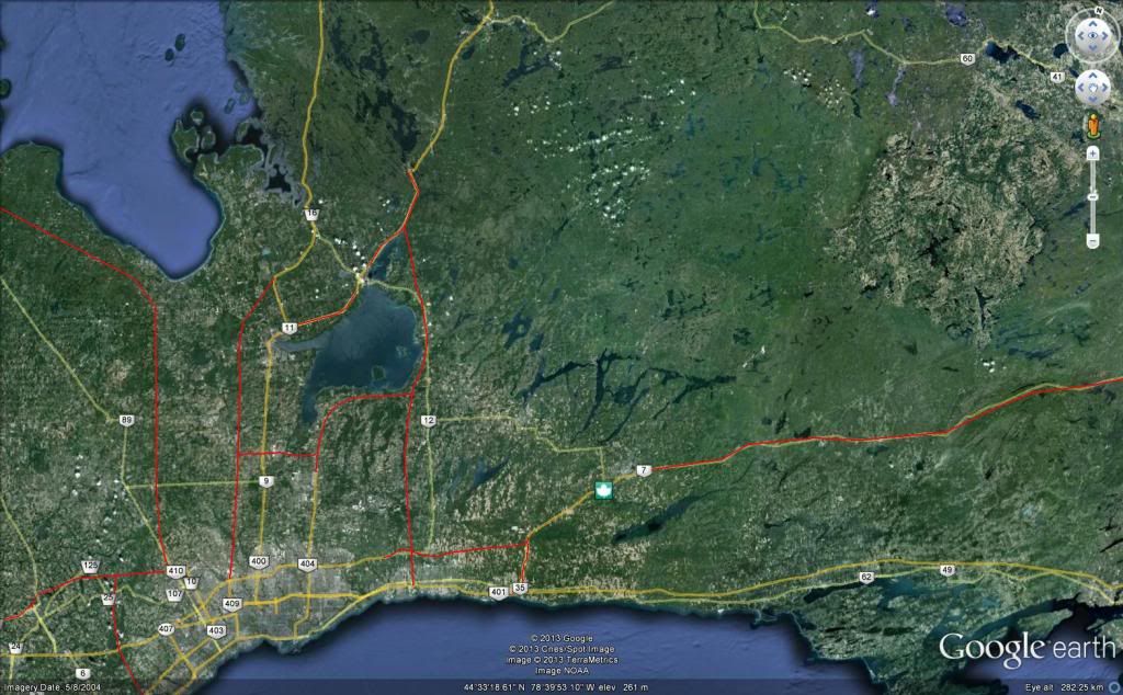
I think the Highway 7 upgrade should be along a new ROW, rather than following the existing one. There are some stretches of the road that are through wide open areas, but substantial portions of the highway have homes/cottages on both sides of the road. And some areas are pretty winding.

For example, from Carleton Place to Perth I think it should go south of Mississippi Lake (the current alignment goes north of the lake and then dips south). When you look at the terminus point of the 4-lane Highway 7 expressway leading into Carleton Place, I think it was designed for 7 to veer south, with an exit going straight into Carleton Place, much like the 400-11 interchange north of Barrie, where the 400 exits off and then veers left. Because it's quite clear that they don't plan on making it a full expressway through Carleton Place, given how much development is right along the current highway.

On a separate note, a Highway 415 from Carleton Place to the 401-137 interchange (the approach highway to the Thousand Islands Bridge/I-80) would make sense as well. Passing near Smiths Falls of course.

I personally think that the 416 was a mistake. Building the 415 connecting to a 4-laned Highway 7 which would then connect to the 417 would have much better served westbound traffic. Eastbound traffic could be served by a twinning of Highway 138 (would become 438). 416 is in a really awkward spot, because both the Thousand Islands Bridge and the Cornwall Bridge are much busier than the Prescott-Ogdensburg Bridge. To access either of those two bridges, drivers need to use the 401, which is already pretty busy. Aside from Kemptville, from Barrhaven all the way to the 401, there's pretty much nothing.
 
Last edited:
I don't think a full grade-separate highway could ever be justified between London and Stratford, however with road tolls in place on the 401 and 402, I could see a full ring road being constructed around the north end of London if it were also tolled. I give you the 428:

5drloy.jpg

This could serve as both Haljackey's possible transprovincial freeway (the mystical 413?) and a connector between it and the 401. The 402 from the junction west to Sarnia could be renumbered to 413 and the section down to the 401 could be decommissioned as the north-south leg of the ring road would become the new connector.
 
Here's a vid of the new Highway 26 bypass between Wasaga and Collingwood.

[video=youtube_share;iKnursFaNKU]http://youtu.be/iKnursFaNKU[/video]
 
Thanks for posting that!

The crosswalk signs at the roundabouts are very different than the Ontario standard, looking more similar to those used in the East and West, and the black-on-white signage is regulatory, rather than cautionary, requiring motorists to give way to pedestrians.

I find the plain signage to Mosley Street disappointing, as it should include the county road 92 shield (esp. it being former Highway 92) - it's not that clear that's the main, and pretty much only, road into Wasaga Beach.

Fences on overpasses are common all over the US, not just in Detroit, even in rural areas.
 
Last edited:
Thanks for posting that!

The crosswalk signs at the roundabouts are very different than the Ontario standard, looking more similar to those used in the East and West, and the black-on-white signage is regulatory, rather than cautionary, requiring motorists to give way to pedestrians.

But there are virtually no pedestrians here, being as it's basically a rural area. It's like putting urban pedestrian crossing signals at traffic lights at rural intersections. There's little point putting them up here.

I find the plain signage to Mosley Street disappointing, as it should include the county road 92 shield (esp. it being former Highway 92) - it's not that clear that's the main, and pretty much only, road into Wasaga Beach.

Mosley St. isn't CR 92 actually. Unlike in Regional Municipalities, actual county roads don't exist in urban municipalities, so when 92 was downloaded, it became a town road. But maybe TO \92/ could have been posted.

Fences on overpasses are common all over the US, not just in Detroit, even in rural areas.

I mentioned Detroit to drive the point home that Ontario doesn't put up those fences elsewhere and that you'd expect that the MTO would put them in cities like Toronto before a non-400 series rural "freeway" with lower traffic volumes.

But I wonder though if the MTO is going to put them up everywhere now.
 
Isn't Mosley Street CR 92? The county road designations disappear in separated cities, such as Barrie, Orillia, or Guelph (where \46/ Brock Road becomes just Gordon Street), but Wasaga Beach is a town, and isn't separate. The signs on old Highway 26 did have \92/ Mosley Street and the Business Section subtext.

The MTO didn't bother with adding \107/ at Bovaird Drive on the 410, there's other examples out there as well. Me thinks the MTO is getting sloppy with its signage (like why try out Clearview, but not adopt it?).
 
Last edited:
Isn't Mosley Street CR 92? The county road designations disappear in separated cities, such as Barrie, Orillia, or Guelph (where \46/ Brock Road becomes just Gordon Street), but Wasaga Beach is a town, and isn't separate. The signs on old Highway 26 did have \92/ Mosley Street and the Business Section subtext.

I could be wrong about towns having county roads, but counties don't have jurisdiction over water/sewers in towns, unlike regions, so roads may be the same. There are no county road signs on Mosley St. The reference to \92/ may just have meant TO 92 or be a sign error.
 
you might be right about Wasaga Beach taking responsibility for all of its own roads.

In any case, it demonstrates the need for a consistent, province-wide road numbering scheme. Motorists don't care who maintains the road, they care about wayfinding and knowing what are quality, through routes.
 
Regarding the 407East. The province said the highway will be tolled, but does anyone know if it includes the West and East Durham Links. Is there any articles that may say either way?
 
Regarding the 407East. The province said the highway will be tolled, but does anyone know if it includes the West and East Durham Links. Is there any articles that may say either way?

I've not seen anything absolutely conclusive, but the two links are always discussed in the context of the "407 East", so I suspect the answer is that they will be tolled.

For the WDL, at least, that could be interesting considering the existence of Lakeridge Road as a fairly fast (today) parallel route with an exit at the main body of the 407. Tolling the WDL could simply result in traffic overflowing to Lakeridge.
 

Back
Top