News   Apr 17, 2024
 1.5K     0 
News   Apr 17, 2024
 361     0 
News   Apr 17, 2024
 2K     1 

Roads: Fantasy Proposals

Dufferin already exists as a local road north of Sheppard - it's the one immediately east of Allen Road. Reconfiguring that would probably require reconfiguring the whole intersection, which is why I didn't actually label the street as Dufferin north of Downsview Park Blvd.

Rename that section 'Old Dufferin'.
 
Here's a concept for a future upload and extension of Windsor's EC ROW, to a 400-series highway which would likely be called Highway 422. EC ROW currently ends at Banwell Road in Tecumseh, and continues at-grade as County Road 22. The road was intended to be extended in the past, but ultimately did not happen due to the Harris government download in the 90s.

The western extension (west of Huron Church) has recently been redone up to 400-series standards after a reconfiguring for the Herb Gray Parkway. The vast majority of the highway, as it sits today, is incredibly inconsistent with design, lacks adequate signage, and has a different layout for every interchange. I can imagine that these would be brought up to a higher standard if an upload was ever considered. My version of the eastern extension would follow the path of the existing CR 22, up until a roundabout at East Puce Road, where it turns south toward County Road 42 through currently existing farmland. It could potentially continue to follow CR 22, but this road gets reduced to 2 lanes and starts to become the main drag of some towns, so going south to get around this would be optimal. An even more eastward extension could be done along CR 42 to eventually meet up with Highway 401 at Tilbury. I have attached some quick mockups of new interchanges for the extension.

Upgrading this highway will be needed in the future, as the towns east of Windsor, such as Tecumseh and Belle River, keep growing in size at a faster rate than Windsor.

This makes me wonder why the 401 was never built along this route in the first place. Windsor would have had a freeway running through it to the border from Day One.
 
View attachment 216113

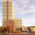
Presenting another idea for a new street grid over parking lots: "Oakville Midtown", which redevelops most of the property to the northwest of Oakville GO, and helps turn Trafalgar Road into more than just a connector between two (planned) dense areas.

The blue zones are the mixed-use, fairly high density buildings that would help create an Oakville skyline. The green are lower-density residential zones (think Cornell in Markham, or row houses), the pink zone is large-format retail, and the red zone is for a school. Light brown roads are less important than the dark brown roads. This arrangement preserves a fair bit of parking, owing to the largely suburban nature of Oakville, but I wanted to try for a balance between serving existing commuters and encouraging new transit-oriented growth.

(Edit: Tagging @t54zhao since they mentioned Oakville GO as one site of "wasted potential" among others.)

I see the tag, but I didn't receive an alert. I like this proposal, it creates a dense neighborhood near transit. I would also add in some pedestrian bridges over the QEW and redevelop some of the single family homes north of the QEW. Those large lots send shivers down my spine. YUGH


I also think that there could be a station at Dixie Rd too. It might be just me, but I hate golf courses especially when surrounded by a bustling city. So inefficient, and what a waste of land that could otherwise be productively used or turned into communal park space. Also hate the way the park system is bisected by golf courses.
 
Oshawa GO also stands out as another location that is hugely wasted.

I feel like new stations (and redevelopment) on the Lakeshore east Line could be built at Harwood , Park Rd (especially since the GM plant is closing) and at Wilson too.
 
Oshawa GO also stands out as another location that is hugely wasted.

I feel like new stations (and redevelopment) on the Lakeshore east Line could be built at Harwood , Park Rd (especially since the GM plant is closing) and at Wilson too.

When you consider that Oshawa is also a VIA Station the situation becomes even more egregious. A station located near the city's core would be great and could encourage redevelopment. Then again Oshawa has become a suburban car centric city so it would be difficult to get away from having at least one station with a massive parking facility.
 
If the E.C. Row Expressway ever ran all the way to connect with the 401, that could be the new Ambassador Bridge/Tunnel route. Good for anyone wanting to access Downtown Windsor & Detroit.

Traffic wanting to bypass these cities would simply continue along the 401 to the new Gordie Howe Bridge.

Seems like a overbuild for a city like Windsor for now, but may as well protect the right of way. Windsor is on a upswing and high housing prices in other Ontario cities will only further drive Windsor's growth as more people move here.

Another 400-series highway through Windsor is definitely more than what is currently needed, but it will be an eventuality as the outer towns add more people. The EC Row will eventually reach capacity and need a full upgrade if the population of Windsor's metropolitan area keeps growing. There are already large traffic issues during rush hour on the County Road 22 section through Tecumseh that would warrant grade separation at the very least.
 
Ya that and a Highway 3 upgrade is part of my crazy fantasy plan ?
(Back on page 3 https://urbantoronto.ca/forum/threads/roads-fantasy-proposals.25983/page-3#post-1144934)

AQ4GmhI.jpg
 
Last edited:

I have thought that Barrie needs a real bypass. My thinking is that eventually Highway 11 will get upgraded, and wen it does, if it is used to extend south as a way to get around Barrie it might give the needed relief of traffic.
 

I have thought that Barrie needs a real bypass. My thinking is that eventually Highway 11 will get upgraded, and wen it does, if it is used to extend south as a way to get around Barrie it might give the needed relief of traffic.
Something like this has been thought about.

map_5.jpg
 

I have thought that Barrie needs a real bypass. My thinking is that eventually Highway 11 will get upgraded, and wen it does, if it is used to extend south as a way to get around Barrie it might give the needed relief of traffic.

The Barrie bypass should go South West and bypass the built up GTA region and connect to the 401 in the Kitchener/Guelph/Cambridge area. From a transport point of view it connects South Western Ontario to Central/Northern Ontario without having to deal with the traffic mess in the central GTA.
 
Some more redevelopments I've cooked up over the past few weeks...

DownsviewRedone.png


Combining my ideas for a redeveloped Downsview Airport and a westwards extension of Line 4 through the property and onto Wilson Avenue. As much as I would have liked to straighten off Sheppard Avenue West, it might be a little too much mess unless everything on Carl Hall Road gets torn up as well. The street grid has been advanced northwards, with some empty space left around the Allen-Dufferin intersection to put in a new high-density development in the future. The Allen-Dufferin section could also be reconfigured to make Dufferin contiguous instead of Allen, but that wasn't as high on my list of priorities.

bovain.png


Next up, the block bounded by Bovaird, Hurontario, Sandalwood, and the OBRY. I extended the Hurontario Main LRT up to Bovaird. Northwest of Bovaird, I transform the line into the "Peel North Railway", which runs on the Orangeville-Brampton tracks directly to Orangeville, with about one train an hour making the trip past Bovaird, potentially stopping at Mayfield Road and/or the village of Alton along the way.

In Brampton itself, the big-box format commercial and industrial zones are turned into a finer street grid, with retail relocated to the frontages of Bovaird, Hurontario, and Main. At and north of Utah Road would still have industrial and commercial uses predominate, but in a denser built form.

steeles mall.png


And the smallest change here, a redevelopment of the southern parking lot of Centerpoint Mall at Yonge and Steeles. A new road would connect to the traffic signals at Athabaska Avenue. The No Frills and Fit4Less would be rebuilt just east of their current locations, which would then be demolished and converted to parking spaces. New townhouses, apartments, and Yonge-fronting retail would fill in the remainder of the block.
 
Some more redevelopments I've cooked up over the past few weeks...

View attachment 239460

Combining my ideas for a redeveloped Downsview Airport and a westwards extension of Line 4 through the property and onto Wilson Avenue. As much as I would have liked to straighten off Sheppard Avenue West, it might be a little too much mess unless everything on Carl Hall Road gets torn up as well. The street grid has been advanced northwards, with some empty space left around the Allen-Dufferin intersection to put in a new high-density development in the future. The Allen-Dufferin section could also be reconfigured to make Dufferin contiguous instead of Allen, but that wasn't as high on my list of priorities.

I like the Downsview redevelopment, and in particular the route for the Sheppard Line west of Allen and the expansion of the Wilson yard.
 

Back
Top