News   Mar 28, 2024
 252     1 
News   Mar 28, 2024
 630     0 
News   Mar 28, 2024
 376     0 

Planned Sprawl in the GTA

I happen to like the Shops (though they are a bit upscale, aren't they?) and it's a fine example of "sprawl repair." But it's a bit of apples and oranges, whether you're comparing it to Cornell or Avondale or Richmond Hill Centre or Oakville. Never forget, for all its charms, it's really just a mall. You don't think there are people living in apartments above the Aroma, do you?

While people may not necessarily be living right above it, there are plenty of people living right across from it.

Screen shot 2015-02-06 at 12.49.07 PM.png


And now there are a number of new condos under construction right next to the shops, along Donway West. Liv Lifts and Flaire come to mind.

urbantoronto-5373-16782.jpg


urbantoronto-2850-16770.jpg


Reflections residences was recently finished.

P1420789.jpg


Photo by i42, Oct 2014


And there is much more on the way over the long term.

IMG_1447.jpg
 

Attachments

  • Screen shot 2015-02-06 at 12.49.07 PM.png
    Screen shot 2015-02-06 at 12.49.07 PM.png
    1.4 MB · Views: 754
  • urbantoronto-5373-16782.jpg
    urbantoronto-5373-16782.jpg
    88.9 KB · Views: 649
  • urbantoronto-2850-16770.jpg
    urbantoronto-2850-16770.jpg
    65.6 KB · Views: 610
  • P1420789.jpg
    P1420789.jpg
    341.2 KB · Views: 633
  • IMG_1447.jpg
    IMG_1447.jpg
    106.7 KB · Views: 639
Yup, that is what I was referring too. I remember seeing those designs when my parents were condo hunting in the area.

I am kinda surprised there are not many UrbanToronto threads nor database articles on these developments. (maybe I just happened to miss them?) This is one of the booming areas of the city.

Liv Lifts and Flaire are both in the database, and have their own threads.
 
Neat. Subscribed now. But those threads are still rather empty and inactive. This area for some reason doesn't generate as much excitement as other 'suburban' developments like on Sheppard.

But I digress. Back on topic, I don't see any reason why we couldn't put residential on top of Aroma Espresso if we wanted to.
 
As for people living above Aroma Espresso... Why not? You can replicate this exact environment in a place like Cornell and plot 4-10s midrise residential on top of all these buildings. And it can be a public initiative too rather than a private one like Shops at Don Mills. The end result would look something like one of those "sprawl repair" images posted above.

Oh,I know people COULD live above an Aroma; they just don't live above the one in that picture, despite the illusory faux windows, suggesting a second story. Yeah, it's true malls are pedestrian scale but it's also true they are specifically designed to maximize sales, in terms of where things are located, where "streets" go etc. They're not optimized for walking so much as getting you towards the stores. That said, the trend of outdoor lifestyle malls is kind of cool; not on Don Mills' scale but there are ones in Milton and Niagara now. I think the real irony might be that the malls are trying to recreate the same "Main Street" shopping we all agree suburbs should replicate; you're just kind of going back to this "reimagining" rather than the source to make your point. But I certainly don't disagree that mall is a nice, walkable environment.

(I know people already live in Don Mills but the SHOPS on Don Mills is a private, retail redevelopment. Not a new, mixed-use urban centre of some kind. And that really harks back to my earlier point about why new urbanist developments often struggle; they can't balance the need to build main-street-oriented retail at the same time/rate as the residential, which goes in first and sells faster. I mentioned that the Beaches community did better because it already had a main street nearby and I think it's the same thing here; it helps the Shops that the residential community was built-in.)

I think the Disera example is a good (if incomplete) one because it does a "Main Street" thing with a real street. They have offices rather than apartments above the stores, but it's still more of a "real" environment than Don Mills. And, as I said, it was the municipality forcing the developer to do it. and the developer is Smart Centres who, historically, are kind of the anti-Christ when it comes to walkable developments.

I enjoyed that mall article, btw. Another good ersatz example is Vegas, where several of the casinos (Venetian, Caesars, for example) have malls that"evoke" an outside main street. Disney, of course, is the quintessential example of taking our ideal, historic town street and doing a fake version. But whether it's Don Mills or Disney or Vegas, it's clear that there is a market for a place you can stroll and do what you want to do; that bodes well for suburban intensification.
 
Last edited:
One of the last infrastructure new developments consider and/or put in, is public transit. The result is usually buses, and bus stops in the worst possible place. See this article from Streetsblog on

the Sorriest Bus Stop in America


at this link.

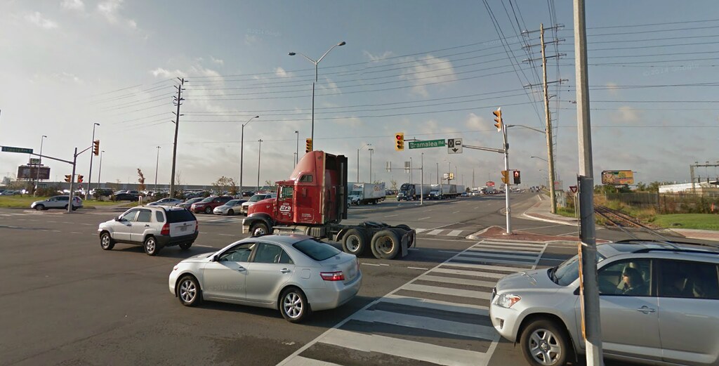
Pennsylvania Avenue in Forestville, Maryland
This entry comes to us from author and transit advocate Ben Ross. This is the same Pennsylvania Avenue that runs past the White House:
Google Street View via Ben Ross

Cleveland’s No. 86 bus, along Route 237
This one was submitted by Tim Kovach of Cleveland. And it actually is a bus stop, believe it or not. The only indication is a small red and blue circle mounted below the I-71 sign (you’ll probably have to zoom in to see it). It’s not at all clear what bus riders are supposed to do when they get off here. Kovach blames inadequate transit funding from the state of Ohio, which devotes just 94 cents annually per resident to transit, although nearly 1 million people across the state lack access to cars.
Google Street View via Tim Kovach

Nashville (Bellevue) Old Hickory Boulevard and Highway 70
This entry comes to us from commenter Coffee Partier, who says the carts are left by shoppers at a nearby Kroger who have to walk across a corner gas station to get to the bus. Extra points for the interrupted bike lane.
Photo via Coffee Partier

Dallas — South Great Trinity Forest Way
Commenter AW82 writes:
This stop has no sidewalk, bench, or shelter. It is along an at-grade state highway with a 50 mph speed limit. Moderately-dense (for Dallas) apartments are across the road. The nearest marked crosswalk (or controlled intersection, for that matter) is 1 mile to the east.

Google Street View via commenter Aw82

Baton Rouge
This beauty was submitted by Janet LaFleur via Twitter, with this caveat:
I’d nominate this one in Baton Rouge except they removed it. Now it’s a one-third-mile walk to next stop.
Google Street View via Janet Lafleur

Encinitas, California
This one comes from @imboande on Twitter, who succinctly sums up the progression from bad to worse:
A year prior, it had a bench.
Photo via @imboande

Houston – 20th Street and Durham
Christopher Andrews in Houston says of this bus stop:
This is an intersection that, as a result of System Reimagining, will be a transfer point between two frequent routes: 20 Cavalcade (which will provide a connection to the Red Line light rail) and the new 50 Route… There’s no bus shelter, trash receptacle, light or bench. Houston’s sun, heat and sudden downpours can make waiting for a connecting bus a very unpleasant experience. There are also no crosswalk signals and inadequate crosswalk painting in all of the crosswalks. In a city that’s ruled by cars, pedestrians should have all the protection they can get if they must cross major thoroughfares to access frequent transit routes and transfer points.
Photo via Christopher Andrews

St. Louis County
This comes to us via Alex Ihnen of NextSTL, who writes:
Short of a bus stop actually in a traffic lane, this must be the worst.
Photo via NextSTL
 
Oh,I know people COULD live above an Aroma; they just don't live above the one in that picture, despite the illusory faux windows, suggesting a second story. Yeah, it's true malls are pedestrian scale but it's also true they are specifically designed to maximize sales, in terms of where things are located, where "streets" go etc. They're not optimized for walking so much as getting you towards the stores. That said, the trend of outdoor lifestyle malls is kind of cool; not on Don Mills' scale but there are ones in Milton and Niagara now. I think the real irony might be that the malls are trying to recreate the same "Main Street" shopping we all agree suburbs should replicate; you're just kind of going back to this "reimagining" rather than the source to make your point. But I certainly don't disagree that mall is a nice, walkable environment.

(I know people already live in Don Mills but the SHOPS on Don Mills is a private, retail redevelopment. Not a new, mixed-use urban centre of some kind. And that really harks back to my earlier point about why new urbanist developments often struggle; they can't balance the need to build main-street-oriented retail at the same time/rate as the residential, which goes in first and sells faster. I mentioned that the Beaches community did better because it already had a main street nearby and I think it's the same thing here; it helps the Shops that the residential community was built-in.)

I think the Disera example is a good (if incomplete) one because it does a "Main Street" thing with a real street. They have offices rather than apartments above the stores, but it's still more of a "real" environment than Don Mills. And, as I said, it was the municipality forcing the developer to do it. and the developer is Smart Centres who, historically, are kind of the anti-Christ when it comes to walkable developments.

I enjoyed that mall article, btw. Another good ersatz example is Vegas, where several of the casinos (Venetian, Caesars, for example) have malls that"evoke" an outside main street. Disney, of course, is the quintessential example of taking our ideal, historic town street and doing a fake version. But whether it's Don Mills or Disney or Vegas, it's clear that there is a market for a place you can stroll and do what you want to do; that bodes well for suburban intensification.

These malls may be geared towards getting you to stores, but the concept is still the same, we would want to gear our public streets towards public spaces and uses, transportation access, and surrounding institutional, retail and office places. I think the point here is that there are certain elements done right by these mall environments that we want to replicate onto our public streets and neighbourhoods.

What are these elements? Narrow streets built to the human-scale, and the minimization of non-places are the two biggest ones I find. (More blogposts for you to read up on, I also recommend this one if you intend on doing some late night reading :) )

The examples posted in the previous page of new "good" suburban areas still lack these elements. Similarly, I find the renders for the area near Yonge and Langstaff, while being more public transit oriented (for York Region standards anyway, I anticipate a similar mode share to Sheppard condos), still lacking in the public realm. You still have big arterials and wide side streets leading up to the buildings meant for an automobile environment. On the surface it looks like a "tower in the park with GO/TTC access". (Which again, don't get me wrong is a big improvement for 905 standards, but still falling short to building a truly pedestrian environment. Think Avondale compared to NYCC.)
 
One of the last infrastructure new developments consider and/or put in, is public transit. The result is usually buses, and bus stops in the worst possible place. See this article from Streetsblog on

the Sorriest Bus Stop in America


at this link.

Incredible. These suburbs are a no mans land if you don't have a car. Some of these cities are so hopeless that they truly deserve to die long before the world's oil supply runs out. But of course before that happens the US will probably raid every oil well on the planet to preserve their stupid suburban way of life for as long as possible, rather than smarten up now. Most cities have either stopped growing and thus can't redevelop, or are still growing but have decided to continue sprawling rather than implement smart growth policies like in Toronto. Eventually these suburbs will become unliveable and end up in the same toilet as Detroit (if that hasn't happened yet).

But that being said, I've seen some awful bus stops in the GTA that were only slightly better. This one is at Bramalea Rd & Boyden, just north of Derry Rd. In December had to pick up a package at the nearby fedex facility, and the employees looked at me like I'm crazy because I took the bus to get there (gee I wonder why). When it was time to go home, this is where I waited for the bus. I was blasted by wind from every speeding truck that passed by. There was no sidewalk. There was no shelter or bench. The grass was all mud. All that was provided was a piece of metal stapled to a poll, which didn't even have the route number on it. But at least it had the customer service number, which I eventually phoned to ask when the hell is the bus gonna come. Took about 20 minutes.

16436142576_284cfe6694_b.jpg


Then later I got off the bus at Bramalea & Steeles to transfer to another bus. What Brampton loves to do is put the bus stop really far away from the intersection, because how dare anything gets in the way of a turning car. So I have to walk from here all the way to the traffic lights.

16274711080_cde035b886_b.jpg


Then I have to wait forever for the green light, and cross this huge road twice to get to the opposite corner. I detest those ramps and pedestrian islands that you see all over Peel region.

15842058033_47dbaa4e44_b.jpg


Then finally I have to again walk a long time to get to the next bus stop. Look how far this is from the traffic lights. It prevents the bus from blocking the right turn lane, but it took over 5 minutes to walk from one bus stop to the other. This never happens on the TTC, plus many intersections have an east side stop and west side stop. You couldn't pay me to live in Brampton.

16275897879_a93f6878af_b.jpg
 
Last edited:
Then finally I have to again walk a long time to get to the next bus stop. Look how far this is from the traffic lights. It prevents the bus from blocking the right turn lane, but it took over 5 minutes to walk from one bus stop to the other. This never happens on the TTC, plus many intersections have an east side stop and west side stop. You couldn't pay me to live in Brampton.

16275897879_a93f6878af_b.jpg

To be fair, most ZUM stops are closer to the intersection than this - I believe this one was placed there to be closer to the GO station. However, your point still stands. The 905 suburbs have done an awful job of making transit user-friendly and intersections pedestrian-friendly. I live in Brampton, and while I live in one of the most transit rich areas of the city, there is a long way to go before transit isn't a second-tier way of getting around.
 
To be fair, most ZUM stops are closer to the intersection than this - I believe this one was placed there to be closer to the GO station. However, your point still stands. The 905 suburbs have done an awful job of making transit user-friendly and intersections pedestrian-friendly. I live in Brampton, and while I live in one of the most transit rich areas of the city, there is a long way to go before transit isn't a second-tier way of getting around.

That is precisely why the Bramalea stop on the Steeles Zum route is where it is.....if it were closer to Bramalea road people would be on here noting how stupid it is to have a higher order bus route stop so far from a regional bus/rail depot like the Bramalea GO station.

There are many things we do wrong in Brampton but I think the city does as good a job as any suburban city (better than a lot) in its transit system growth/development....yes there is a long way to go (and they seem to be willing to go that long way) but when I use BT I don't feel all that inconvenienced.

As for the Boylen Road stop.....seems a bit harsh to be calling out Brampton Transit on the state of a stop serving a primarily industrial area of another city....no?
 
Last edited:
These malls may be geared towards getting you to stores, but the concept is still the same, we would want to gear our public streets towards public spaces and uses, transportation access, and surrounding institutional, retail and office places. I think the point here is that there are certain elements done right by these mall environments that we want to replicate onto our public streets and neighbourhoods.

Yeah, I don't really disagree. I just don't think you can look at a mall and really say, "Our neighbourhoods should be like this!" any more than you can do it with Disneyworld. But narrow streets, proper scale etc; I'm down with all that, of course.

The examples posted in the previous page of new "good" suburban areas still lack these elements. Similarly, I find the renders for the area near Yonge and Langstaff, while being more public transit oriented (for York Region standards anyway, I anticipate a similar mode share to Sheppard condos), still lacking in the public realm.

Maybe it would help if you saw the ground-level renders because your impression is incorrect. There is a single road that goes from Yonge to Bayview and that's why they designed the Langstaff area (and the RH side, to a lesser extent) to an extreme transit-oriented degree. Because of the physical constraints at the site (and the phasing regime they built into the zoning) it's very unlikely it would end up like Avondale. There are unknowns and things change but the modal share target is 65%-non-auto, which is downtown-level. The final phase, at least on paper right now, can't proceed unless all the transit infrastructure is in place and they've already achieved 50%. Proceeding with more development without either of those things...well, it just doesn't work.

You can't erase the presence of Bayview and Yonge (or 7 and 407) but the access is so limited from the Markham side that they effectively said, "we're not taking those into account; we're operating on the assumption the roads basically can't take any more traffic." There are no wide arterials or anything like that within and lots of public realm, including a park that goes the entire length of the Markham side. Au contraire, the emergency services and transit people were very concerned about how narrow the roads are supposed to be.
Langstaff 3.jpg


(This is slightly less true of the RH side which is closer to NYCC in that it's partially developed but it's already off to a good start in terms of density. Depends how you look at it: The Markham plan is amazingly ambitious but the RH plan is arguably more achievable....)

If it turns out as planned (and I acknowledge it's a big if as of today), it will put NYCC to shame in terms of transit orientation and modal share.
 

Attachments

  • Langstaff 3.jpg
    Langstaff 3.jpg
    137.8 KB · Views: 759
I think for Toronto, the turning point from walkable subdivisions to auto-oriented subdivisions, began by 1952. From this link:

Sunnybrook Plaza, the first suburban strip plaza built in Toronto, has been proposed for demolition and redevelopment. This first collection of stores in the city with a parking lot out front was opened on the northeast corner of Bayview and Eglinton Avenues in 1952.

14988-44129.jpg


Now that the Bayview Station of the Crosstown LRT is to use this corner as an entrance, the plaza is to undergo a redevelopment.

However, at the time (1952), the plaza was a foreshadowing of the sprawl that was to come. Before 1952, the new subdivisions were still walkable with storefronts facing the street. After 1952, the strip mall, following by the shopping centre, and later shopping malls, hand in hand with the restrictive single-use zoning created a less walkable environment.
 

Attachments

  • 14988-44129.jpg
    14988-44129.jpg
    62.2 KB · Views: 513

Back
Top