News   Jan 09, 2025
 295     0 
News   Jan 09, 2025
 391     0 
News   Jan 09, 2025
 527     0 

New Electoral Boundaries

Rosario's not retiring. He was door knocking on my street last night. I would guess he has run the poll-by-poll numbers and is worried.

I don't want to slander the guy, but when I asked him why he said that he was going door to door because "it's hard to get in the media unless you do something special." Gee Rosario, maybe you should do something "special".

There's the updates to the Condo Act for better consumer protections and more board accountability he's been pushing hard for, but the Liberals (perhaps because of ties to the development industry) aren't interested.
 
That's true. And nobody at Queen's Park is high profile, except the leaders and a few cabinet ministers.
 
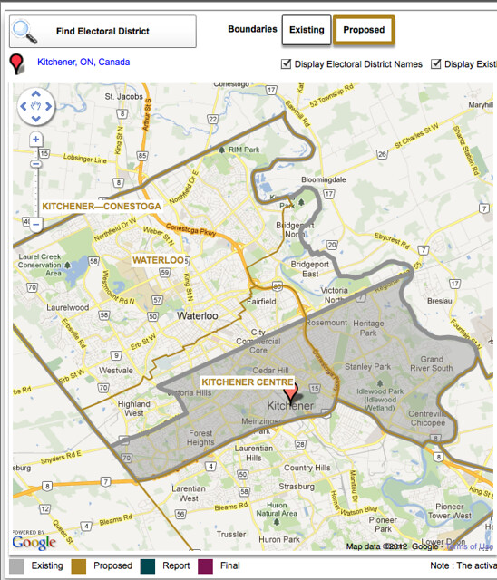
One of the more asinine ridings in my opinion has to be this one:

Federal%20Electoral%20Districts%202012%20Redistribution%20-%20August%202012%20-%20Kitchener%20South%20-%20North%20Dumfries%20-%20Brant.jpg


Kitchener has a population of 219,153 and would easily fit entirely within 2 census districts, so I'm not sure where they got the idea to divide it along the highways and stretch Kitchener's representation to the border of Brantford
 
Though keep in mind that the ridings might be drawn with growth assumptions in mind--and at this point, Mississauga's basically built out, but with continuing growth in Bramption, by the next redraw there's a more-than-reasonable chance that Brampton will have more--maybe significantly more--residents per riding than Mississauga...

I don't think that's the way it's done. They use the Census figures, not assumptions as far as I know.

Malton split in two? Cooksville and Downtown Brampton each split between THREE ridings? I don't like these new boundaries.

The names don't make sense either. Like Brampton Centre only includes a small portion of the downtown and extends further south than Brampton South.

Malton is glaringly badly split. In my post above I mentioned Mississauga—Meadowvale, I should have written Mississauga—Malton.

i.e. if I were doing it I would have had:
Mississauga—Erindale
Mississauga—Streetsville
Mississauga—Cooksville
Mississauga—Malton
Mississauga—Clarkson
Mississauga—Port Credit
which would more or less mirror the existing exchanges/former towns

From Wikipedia http://en.wikipedia.org/wiki/Area_codes_905_and_289:

Mississauga is divided into the following local rate centres:

Clarkson: (289)-299 326 373 420 628 825 826 849 898, (905)-254 403 491 822 823 855 916 919
Cooksville: (289)-232 261 327 360 362 374 421 444 521 628 633 724 777 805 883, (905)-206 210 212 214 219 232 238 241 247 267 268 270 272 273 275 276 277 279 281 282 283 290 306 361 366 402 501 502 507 566 568 602 614 615 624 625 629 712 755 756 766 803 804 848 890 896 897 949
Malton: (289)-247 328 359 548 562 623 625 804 865 904 988, (905)-234 255 256 293 298 362 364 405 461 564 565 612 670 671 672 673 676 677 678 694 696 698 740 795 908 956
Port Credit: (289)-297 329 643 822 847, (905)-221 271 274 278 486 891 990
Streetsville: (289)-290 305 334 375 652 814 848 896 914 997 998 999, (905)-236 285 286 288 301 302 363 369 412 542 567 569 593 600 601 603 606 607 608 609 785 812 813 814 816 817 819 820 821 824 826 828 858 997


One of the more asinine ridings in my opinion has to be this one:

Federal%20Electoral%20Districts%202012%20Redistribution%20-%20August%202012%20-%20Kitchener%20South%20-%20North%20Dumfries%20-%20Brant.jpg


Kitchener has a population of 219,153 and would easily fit entirely within 2 census districts, so I'm not sure where they got the idea to divide it along the highways and stretch Kitchener's representation to the border of Brantford

That certainly does look stupid. Gerrymandering?
 
Last edited:
For some reason they grouped Brant into the Region of Waterloo when they were calculating for increase in population
 
That certainly does look stupid. Gerrymandering?

Not as stupid as the old Kitchener-Conestoga.

The Libs seem to get the better of this deal. By cutting the rural areas off the K-W urban ridings, the Libs will now have a lock on Kitchener Centre. They even probably have a better shot at Waterloo. In exchange the Conservatives get this new riding for themselves forever.
 
Not as stupid as the old Kitchener-Conestoga.

And in fact, the "orphaned" part of urban Kitchener here is identical to the "orphaned" part of urban Kitchener in K-C. So, it's just swapping one rural zone for another.

The Libs seem to get the better of this deal. By cutting the rural areas off the K-W urban ridings, the Libs will now have a lock on Kitchener Centre. They even probably have a better shot at Waterloo. In exchange the Conservatives get this new riding for themselves forever.

Actually, the K-W urban ridings had already been de-ruralized in prior redraws; so, not much change here...
 
And one proposed riding that's woefully misnamed: Oak Ridges (which encompasses most of King and NE Vaughan)--IMO the name really ought to belong to something inclusive of the community of that name which gave the Moraine its name (which happens to be in Aurora-Richmond Hill)
 
And in fact, the "orphaned" part of urban Kitchener here is identical to the "orphaned" part of urban Kitchener in K-C. So, it's just swapping one rural zone for another.


Actually, the K-W urban ridings had already been de-ruralized in prior redraws; so, not much change here...

Sorry, I meant the Tories suburbs to the east of Hwy 85.

7884897890_c3bde9354b_z.jpg
 
I don't think that's the way it's done. They use the Census figures, not assumptions as far as I know.

There is a pretty good description of how it is done at the Elections Canada website.

http://www.elections.ca/content.aspx?section=res&dir=cir/red/form&document=index&lang=e


elections canada said:
1 – Initial allocation of seats to the provinces
The population of a province is divided by the “electoral quotient” to provide the initial allocation of seats to that province. For this redistribution process, the electoral quotient is set at 111,166.

Note: For future redistribution processes, the electoral quotient will be adjusted to reflect average provincial population growth since the previous redistribution

Essentially they set a sort of targeted "average" per riding....use that to calculate how many ridings each province should get and then work with the real world to establish them.

Excluding the random pocket of Mississauga in a Brampton riding, Mississauga's 713,443 residents are served by 6 ridings (@ 118,907 residents per riding) and Brampton's 523,911 residents are served by 5 ridings (@ 104,782 residents per riding) using 2011 Census numbers.

Transferring the, what, 40k people who live in Malton.......673,443 served by 6 = 112,240 per riding.....transfering those to Brampton.....563,911 served by 5 = 112,782 so (depending on what the estimated/population of the shifted {for election purposes} people....no one is getting the shaft (the popluation of Malton that creates exactly the same population per riding is 38,522)......the point is, really, that shifting Malton to one of the 5 Brampton ridings is a) historically consitent {they are coming out of Bramalea-Gore-Malton, after all) and (more importantly) the shift of people between Brampton and Mississauga that is the easiest way to get both municipalities as close to that provincial quotient and c) does so, now, with just one shared riding.

Faced with the alternative, I guess if you felt Mississauga was getting shafted you might want to keep all of Mississauga's population together and assign 7 ridings.......(101,920 per riding)....I guess, also, that would achieved by removing one of Brampton's ridings.....so the remaing 4 purely Brampton Ridings would have 130,977 per riding?

I think within the context of Peel Region's large cities, the recommended number of ridings makes perfect sense.
 
Last edited:
And one proposed riding that's woefully misnamed: Oak Ridges (which encompasses most of King and NE Vaughan)--IMO the name really ought to belong to something inclusive of the community of that name which gave the Moraine its name (which happens to be in Aurora-Richmond Hill)

The Oak Ridges riding should be called "King-Vaughan" - I think that name may have existed in the past and included a bit more of Woodbridge. This is confusing since the town of Oak Ridges - which has been swallowed up by Richmond Hill - starts at Bathurst Street, which is the end of the riding. No part of the town of Oak Ridges in in the "Oak Ridges" riding.
 
The United States has some of the weirdest borders for their Congressional Districts. Look at this one in Illinois:

3446898712_b0dae23ea9_b.jpg


The 4th congressional district of Illinois is one of the worst examples of gerrymandering in current US political geography. It is sometimes called "the horseshoe" district because of its shape. The district includes two separate East-West strips, one largely Puerto Rican the other Mexican in population. In order for it to be considered a single district, the entire land area must be connected. In this case, the two strips are barely connected by a thin strip of land that follows the Interstate Highway 294. There is no population contained in this strip so it serves solely as a connector.

Gerrymandering is widespread across the United States and other countries. It was named after, Massachusetts Governor Elbridge Gerry who's party drew up a serpentine-shaped district to favor Gerry in his upcoming election. Gerrymander is a combination of Gerry and Salamander. Today Gerrymandering is favored by both Democrats and Republicans to preserve the status of their party in certain districts. Gerrymandering has numerous negative impacts on the voting population including,
-- less competitive elections
-- increased security for the incumbant
-- more loyalty to the party and less to the district's population

This lack of focus on the population being represented means that voters are disenfranchised which can the reduce voter turnout.

Numerous attempts have been made to reverse gerrymandering with only a few success stories. Because gerrymandering often favors both parties (albeit in separate districts) there is little chance of re-districting bills getting the necessary support to pass.

Could it happen here?
 
The proposed Kitchener-Conestoga riding is the same - obvious gerrymandering.

Transferring the, what, 40k people who live in Malton.......673,443 served by 6 = 112,240 per riding.....transfering those to Brampton.....563,911 served by 5 = 112,782 so (depending on what the estimated/population of the shifted {for election purposes} people....no one is getting the shaft (the popluation of Malton that creates exactly the same population per riding is 38,522)......the point is, really, that shifting Malton to one of the 5 Brampton ridings is a) historically consitent {they are coming out of Bramalea-Gore-Malton, after all) and (more importantly) the shift of people between Brampton and Mississauga that is the easiest way to get both municipalities as close to that provincial quotient and c) does so, now, with just one shared riding.

Only a part of Malton is included in that Brampton riding, that's the problem. Whether as part of a Mississauga riding or Brampton riding, it should all be one riding. I think it's unacceptable to split small isolated communities like that.
 
Last edited:
Only a part of Malton is included in that Brampton riding, that's the problem. Whether as part of a Mississauga riding or Brampton riding, it should all be one riding. I think it's unacceptable to split small isolated communities like that.

That I agree with....not sure what value there could be in having a very small part of Malton disconnected (electorially) from the rest. The only part that is not part of Brampton-Gore in this proposal is south of Morningstar, East of Airport Road, north of Derry/Rexdale and west of Goreway.
 
Last edited:
I've given the Waterloo-Brant area by best shot at redistribution and was wondering what some others thought. http://goo.gl/maps/lJnN7 I did my best to keep Kitchener in one peice but some of the more rural areas of Kitchener and Cambridge needed to be separated in order to increase the population in the Waterloo Townships - Dumfries riding. The Six Nations and Missisaugas reserves were also transferred back to Haldimand - Norfolk to make the gerrymandering less extreme.
 
Last edited:

Back
Top