News   Jan 21, 2025
 895     0 
News   Jan 21, 2025
 509     1 
News   Jan 21, 2025
 688     0 

Miscellany Toronto Photographs: Then and Now

Richmond St. East

Hi there. I had to review this whole thread. It's taken me 3 days, and I have finally reached it at 4am Thursday.

What a thread. I am one of the original Toronto kids. Born at East York, lived on Thorncliffe Avenue by Broadview & Danforth for 8 years, moved to Yonge & St. Clair for 30, and am living in Leslieville now. My Dad owned his own business on Queen East beside CityTV, then moved

If you can catch the back alleyway around 111 Queen East (those buildings had to have been renumbered since then), I'm sure it has a lot of undisturbed brick. My Dad's Cadillac was swiped back there by the loading dock, and the guy took off. He then purchased 282 Richmond St. E. The whole neighbourhood was pretty cool back then. It's unrecognizable now. Here's a Then and Now. Not much difference, other than 'modernized' I guess.

Then.jpg


Now.jpg


Does anybody have any pictures or information on Upper Canada College or Branksome Hall? I attended the latter (yes I'm a male, but they had a handful of males back in the day) for 5 years, then 10 years at UCC. I'd love to see any pics of either at any point.

Cheers. Again, great thread.
 

Attachments

  • Then.jpg
    Then.jpg
    99.1 KB · Views: 709
  • Now.jpg
    Now.jpg
    18.4 KB · Views: 678
Thanks for that correction, spider.
Here's another photo from the same area.
I wish the location was more precise so that a "Now" image could be provided.

I think that Goldie might have had it correct in the first place, based on the 1947 aerial photos on the Toronto Archives website.

Don20Mills20x.jpg


DonMillsLawrence.jpg
 
Further to the history of Don Mills and Lawrence, my recollections are reinforced in the "Illustrated Atlas of The County of York" ISBN 0-919302-35-1 which is a reprint of an 1878 Atlas and in "Pioneering in North York" written in 1968 by Patricia W. Hart for the North York Historical Society.
I am sure both books are available in Toronto libraries.

The aerial photograph posted is as I recall the intersection, the Watson house with outbuildings as you would expect in a rural home occupies the NW corner and the school on the East side of Don Mills south of Lawrence. This school is the second Don school, the first was a half mile north on the Hogg property.
 
Ah that was next door. Originally it was Errols. Owner was a famous guy who...spent some time in jail from what I gather. John Candy used to hang out there. Then it turned into a restaurant, then The Stonecutter's Arms, then The Rogue.

I opened up a brewery in Guelph, and ironically, they were shooting a commercial in The Stonecutter's Arms, while we had our taps on, so they had to get our permission to show it. Of all places.

My Father's business being downtown, introduced me to old Toronto and the flare that is downtown. You can't get that anywhere else in Canada. It's why I bought in Leslieville.
 
Further to the history of Don Mills and Lawrence, my recollections are reinforced in the "Illustrated Atlas of The County of York" ISBN 0-919302-35-1 which is a reprint of an 1878 Atlas and in "Pioneering in North York" written in 1968 by Patricia W. Hart for the North York Historical Society.
I am sure both books are available in Toronto libraries.

The aerial photograph posted is as I recall the intersection, the Watson house with outbuildings as you would expect in a rural home occupies the NW corner and the school on the East side of Don Mills south of Lawrence. This school is the second Don school, the first was a half mile north on the Hogg property.

I can see it now, thanks. The 1878 Atlas is online
http://digital.library.mcgill.ca/countyatlas/search.htm

Wasn't Aggie Hogg's house also the post office? If so, it is marked on the 1878 map near a creek that no longer exists...
 
Converging lines in architectural photography

Besides being an interesting photo of the Hermant, it's interesting that the sides of the building don't converge towards the top of the photo. Perhaps the photographer used a "tilt-shift" lens?

In the 'old days' when the Hermant Building was photographed, a professional photographer probably used a 'view camera' such as this.
With ANY CAMERA it's only necessary to keep the 'film plane' absolutely vertical in order to avoid 'converging lines'.
A 'tilt-shift' lens doesn't really solve the problem.
The camera in this illustration is equiped with a 'rising'front' in order to move the lens vertically.
 

Attachments

  • view camera.jpg
    view camera.jpg
    73.3 KB · Views: 325
I think that I can forget the web any for answers; between you & Clint

everything can be covered.

Thank you Prof. Goldie.


Regards,
J T
 
Wasn't Aggie Hogg's house also the post office? If so, it is marked on the 1878 map near a creek that no longer exists...

The 2nd book cited in my previous post states that John Hogg became the first postmaster in his frame store in 1868, Agnes took over the post office in 1869 in her new brick store.
 
The 1959 was a set back from the street with parking in the front. It was north of the corner. The corner consisted of a building right on the corner. For many years it was a John Anderson's greasy spoon. I spent many late nights eating burgers and onion rings here.

They served up a great Souvlaki dinner back in the day as well, and breakfast lol
I lived in North York for 25 years out of the 31 years I have been in Canada. It is amazing how much it has changed.
 
March 31 addition.


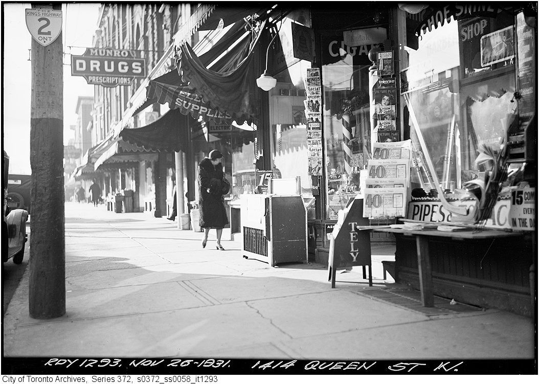
Then. "Nov. 26, 1931. 1414 Queen Street W."


s0372_ss0058_it1293.jpg


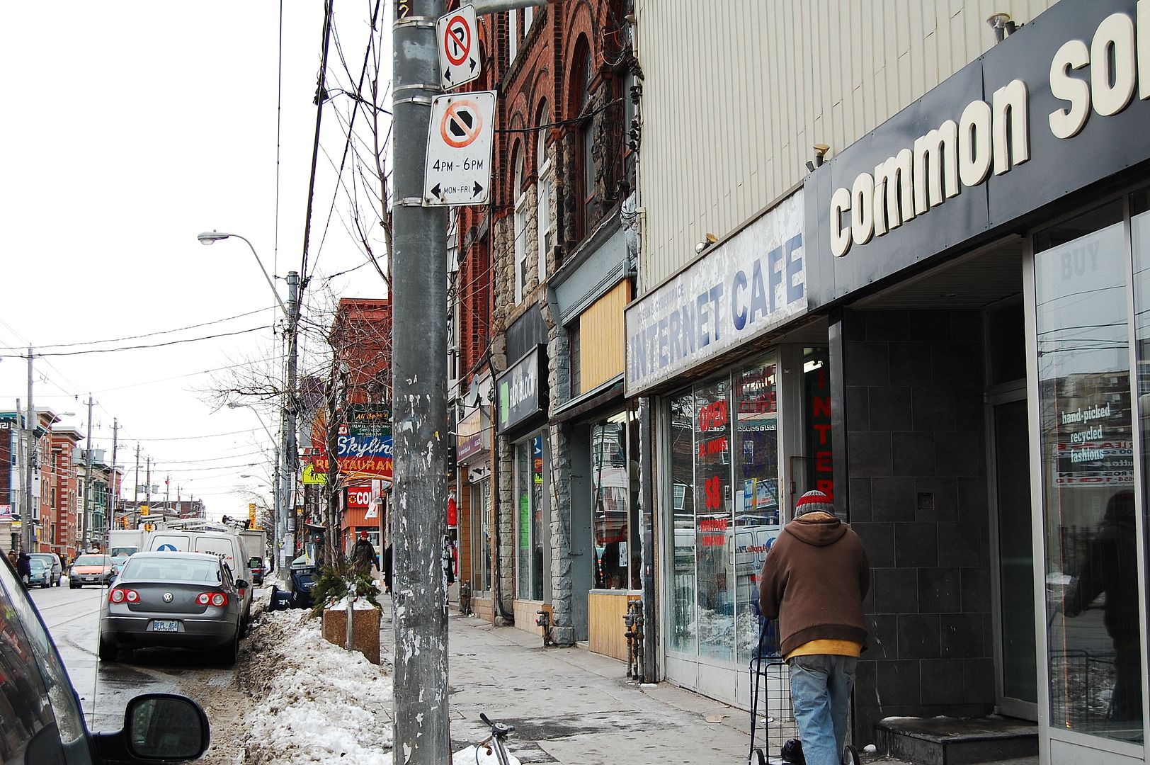
Now. March 2011.


DSC_0126-1.jpg


Now.
The old photo is one of the best I've seen from the archives, worthy of Berenice Abbott, in "capturing the moment". All the elements hang together beautifully.

Just wondering though, where did the sidewalk go from 80 years ago? And the public realm, with today's hydro poles? Don't get me started.....
 

Back
Top