|
|
|


You are using an out of date browser. It may not display this or other websites correctly.
You should upgrade or use an alternative browser.
You should upgrade or use an alternative browser.
Jasonzed's myDrone Activity of Toronto and Area
- Thread starter Jasonzed
- Start date
- Status
- Not open for further replies.
Jasonzed
Senior Member
Jasonzed
Senior Member
Jasonzed
Senior Member
Full Metal Junkie
Active Member
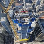
Just a bit of curiosity on my part. Some of the drone shots have the line of horizon tilted. This used to be more pronounced with the drone that met its demise by getting too friendly with a bird. The horizon is tilted down to the left or to the right, sometimes both ways in separate shots from the same flight session. Is this because you are taking the shot as the drone is actively maneuvering (rotating left/right)? Fighting a wind gust maybe? Why the difference between the previous drone and this one? Do you ever manually correct the line of horizon in postproduction?
Last edited:
Jasonzed
Senior Member
Just a bit of curiosity on my part. Some of the drone shots have the line of horizon tilted. This used to be more pronounced with the drone that met its demise by getting too friendly with a bird. The horizon is tilted down to the left or to the right, sometimes both ways in separate shots from the same flight session. Is this because you are taking the shot as the drone is actively maneuvering (rotating left/right)? Fighting a wind gust maybe? Why the difference between the previous drone and this one? Do you ever manually correct the line of horizon in postproduction?
More often than not it's related to the DJI GO software. When the image is lost and then re-established the camera does not fully regain its "alignment". Sometimes I bring it down and reboot the drone or I just take a picture and just leave it and that. I don't do much post-production, I'm not that sophisticated
")
Jasonzed
Senior Member
Railway museum is Smith Falls

Last edited:
Tim MacDonald
Senior Member
You can also adjust the gimbal tilt in flight to manually straighten the horizon.More often than not it's related to the DJI GO software. When the image is lost and then re-established the camera does not fully regain its "alignment". Sometimes I bring it down and reboot the drone or I just take a picture and just leave it and that. I don't do much post-production, I'm not that sophisticated
Jasonzed
Senior Member
Jasonzed
Senior Member
lenaitch
Senior Member
I ask the following not knowing a lot about Canadian Air Regulations and even less on how they apply to UAVs, but can a UAV be operated this close to the Island Airport?
Tim MacDonald
Senior Member
Depends on if a Special Flight Operations Certificate is granted because the area is part of controlled airspace (Class C from surface to 2500 ft). Without an SFOC, it is a no go area. You'd actually need to be close to the RC Harris Filtration plant to clear the Billy Bishop controlled airspace area. There are other rules at play aside from air space classification that dictates where one can legally fly (eg built up area)..
Jasonzed
Senior Member
Jasonzed
Senior Member
Jasonzed
Senior Member
- Status
- Not open for further replies.