News   Apr 26, 2024
 1.3K     4 
News   Apr 26, 2024
 300     0 
News   Apr 26, 2024
 851     0 

Hamilton: General Service Discussion

Great explanation. I read your article but I didn't understand it as I was missing some context as a non-resident. Now I understand completely and agree.

The Hamilton bike heat map is really cool! I think it could even be the basis for another article. ;)

The concept of tracking bike-share bikes makes a lot of sense. I assume most cities do this with their programs and Toronto is behind the ball as usual?
 
The concept of tracking bike-share bikes makes a lot of sense. I assume most cities do this with their programs and Toronto is behind the ball as usual?
No... Most bikeshare systems don't have GPS-tracked bikes.

SoBi systems require 3G/LTE data built into each bike for real time GPS tracking powered by dynamo/solar. A mobile SIM card embedded in each bike (presumably cheap Bell/Rogers $10 "datashare" SIM cards, possibly cheaper in larger SIM quantities). Most other bikeshares, BIXI, only has GPS embedded in stations only, so undocked bikes are "off the grid".

Hamilton is currently the world's largest fleet of smartbikes -- a.k.a. GPS-tracked bikeshare bikes.

Most don't know this little factoid -- not even all our city councillors -- but this is a Urban Planner Surprise Gift now being pushed to our councillors as we speak (apparently, several of us have emailed now, after Hamilton's bike usage heatmap was publicly released for the first-ever time).
 
Last edited:
West Harbor GO opens tomorrow.

I took a bunch of photos this evening.
WestHarborEntrance.jpg WestHarbourEntranceRoad.jpg 2015-07-08 19.49.58.jpg 2015-07-08 19.51.17.jpg 2015-07-08 19.51.45.jpg 2015-07-08 19.52.19 HDR.jpg 2015-07-08 19.53.24.jpg 2015-07-08 19.54.55.jpg

The branded façade:
...The interior path to the north platform stairs look complete and cleaned up now. The elevator still looks out of service, however they came up with a solution.
2015-07-08 19.52.19 HDR.jpg


The wheelchair accessible path:
This path will connect to the south platform only. Right now it temporarily connects the North platform until all elevators are in service. The pocket track stub will extend onwards (for Lewis layover/Stoney Creek service) once both platforms are in service and corridor work is done.
2015-07-08 19.53.24.jpg


The MacNab entrance:

...It looks complete enough to enter! Nice large plaza that extends to James Street North from MacNab. The GO staff wasn't amused to see me walking inside the zone, but the MacNab construction fence was opened up at the time I walked near. (I apologized and left)
WestHarborEntrance.jpg


The GO Bus Access:
...This is where you board/disembark a GO bus in front of West Harbor.
WestHarbourEntranceRoad.jpg


The Platform:

...All cleaned up, with a fully functioning track, with its pearly white quartz-granite-rock roof. The still-under-construction second entrance at Bay is shown at upper-right, and the parking garage is still under construction (2017), but the platform looks safe and ready!
2015-07-08 19.54.55.jpg
 

Attachments

  • 2015-07-08 19.49.58.jpg
    2015-07-08 19.49.58.jpg
    1.5 MB · Views: 483
  • 2015-07-08 19.51.17.jpg
    2015-07-08 19.51.17.jpg
    1.9 MB · Views: 487
  • 2015-07-08 19.51.45.jpg
    2015-07-08 19.51.45.jpg
    1.8 MB · Views: 502
  • 2015-07-08 19.52.19 HDR.jpg
    2015-07-08 19.52.19 HDR.jpg
    2.2 MB · Views: 953
  • 2015-07-08 19.53.24.jpg
    2015-07-08 19.53.24.jpg
    1.6 MB · Views: 2,277
  • 2015-07-08 19.54.55.jpg
    2015-07-08 19.54.55.jpg
    2.7 MB · Views: 855
  • WestHarborEntrance.jpg
    WestHarborEntrance.jpg
    318 KB · Views: 1,112
  • WestHarbourEntranceRoad.jpg
    WestHarbourEntranceRoad.jpg
    529.4 KB · Views: 791
Last edited:
The wheelchair accessible path:
This path will connect to the south platform only. Right now it temporarily connects the North platform until all elevators are in service. The pocket track stub will extend onwards (for Lewis layover/Stoney Creek service) once both platforms are in service and corridor work is done.
2015-07-08-19-53-24-jpg.50175

Is the entire path temporary?
 
Who thought putting black station name lettering on the glass was a great idea? Maybe it'll look better in the dark if the glass is illuminated or if the letters are backlit. The large gaps in the GO letters don't look that great when the logo is reproduced at a large size.
 
I executed my experimental hybrid SoBi+GO commute today again, but using West Harbor GO instead. Left my car at home.

- 6:27am -- Left home
- 6:28am -- I unlocked a bikeshare (off-rack SoBi bicycle parked only 2 blocks away, shows in map app)
- Rode Hamilton's new Cannon street bike path (still relatively underused, but a valuable resource)
- 6:42am -- I arrived at West Harbor GO
- 6:44am -- Presto reader beeped beautifully.
- 6:45am -- I boarded the 6:46am West Harbor GO train after taking a few photos
- 7:57am -- arrived Toronto Union right on the dot
- 8:02am -- arrived at my cubicle

Commute time: 1h35min

Not bad; that is darn near exactly my most typical Aldershot commute time, leaving by car at 7:45am to catch the 8:08am Aldershot train arriving Union 9:15am, cubicle at 9:20am. Commute time: Also 1h35min

I hereby declare the SoBi+GO West Harbor commute a success -- it took exactly the same as using my car; but without bringing my car. I shall exercise this commute option more often, as I live near the endpoint of the Cannon bike path, giving me a convenient faster bee-line to West Harbor GO. Slightly faster than biking to downtown Hamilton GO.
 
Last edited:
I was on the second-ever West Harbour revenue train at 6:46am. Here are my photos of the experience.

image.jpg image.jpg image.jpg image.jpg image.jpg image.jpg image.jpg image.jpg image.jpg image.jpg

Parking my SoBi and arriving at the station
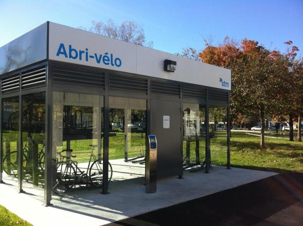
After riding my SoBi on the Cannon Street bike path, I parked at the bike rack. Many many construction employees were in the plaza to welcome the first commuters. With three to four minutes to spare, I quickly snapped a bunch of photos.
image.jpg

image.jpg


Commuters crossing the bridge
This is the scenic part of my arrival.
image.jpg


The commuter POV
Feels like a real GO station. Ahh, new platform smell -- the faint smell of new sidewalk concrete.
image.jpg


Passing the waterfront CN rail yard
It feels very different being a passenger going through here.
image.jpg


The lake looparound
Curving around the eastmost tip of Lake Ontario, I see Hamilton steeltown industry in the far distance.
image.jpg


The Canadian Moment
With the industrials fading away behind -- it became idyllic for a moment. Several early morning canoeists and kayakers were having fun in this area. A uniquely idyllic Canadian moment worth heading to West Harbor GO instead of Hamilton GO, if you want the best lakefront view from the train.
image.jpg


And then familiarity instantly came, as we approached Aldershot. Felt weird approaching Aldershot rather than departing Aldershot, as in my usual car commute.

This 6:46am train departed right on the dot, and arrived at Union at exactly 7:57am.
This commute was brought to you by SoBi & GO.
Now please bring Niagara Summer Service to Hamilton next year! :)
 

Attachments

  • image.jpg
    image.jpg
    1.6 MB · Views: 780
  • image.jpg
    image.jpg
    1.5 MB · Views: 795
  • image.jpg
    image.jpg
    2.3 MB · Views: 1,017
  • image.jpg
    image.jpg
    1.3 MB · Views: 494
  • image.jpg
    image.jpg
    1.4 MB · Views: 783
  • image.jpg
    image.jpg
    1 MB · Views: 449
  • image.jpg
    image.jpg
    1.3 MB · Views: 749
  • image.jpg
    image.jpg
    1.2 MB · Views: 717
  • image.jpg
    image.jpg
    800 KB · Views: 766
  • image.jpg
    image.jpg
    723.2 KB · Views: 471
Last edited:
mdrejhon - Do you work inside Union Station or something? That's pretty quick for arrival->cubicle!

Also...wonder if I saw you taking photos at West Harbour last night. There were a few people looking / snapping while I was there. I was the blue bike guy (blue bike, blue shirt, blue helmet...heh).

I took the first 6:16am train this morning (less than 10 minutes to bike there from just up The Mountain!). Will probably post some photos tonight or tomorrow.

I also rode around town a bunch last night while I was there. Finally got to try the Canon St. bike lanes. Quite a good experience there, and I was impressed at how heavily they were used (probably around 8pm).
 
mdrejhon - Do you work inside Union Station or something? That's pretty quick for arrival->cubicle!
No, but very close. I work three blocks away in the Financial District. I make sure to disemark via the Bay teamway. Much faster than going through the Union interior.

Also...wonder if I saw you taking photos at West Harbour last night.
Yes, it might have been me if you saw a redhead-blonde carrying an iPhone camera.

10 minutes to bike down from the Mountain? Nice! You really need to tell your Toronto commuting neighbours that. The return bike trip probably must be a pain, though.
 
Yeah, I grew up just on top of the mountain, and parents are still there (I live in TO now). Bike ride to West Harbour is faster than walk down James St. stairs to Hamilton GO Centre. I even took it a bit slower than in the past...it's been a while since the last time I went flying down that hill so I wasn't quite as comfortable. Many red lights too.

People should definitely consider riding to those early trains. The city seems so quiet at that time of day too.
 
Thanks for the great inaugural run post! I wonder how many actually used this first day service? I should also be interesting to see how many from downtown Toronto use it for the ArtCrawl.
 
Thanks for the pics, mdrejhon. Look forward to riding it next week.

How seamless is the connection between the 20 A-Line and the station?
 
Great photos mdrejhon!

My question to you is: how far is the SoBi bike parking from the GO station?

My impression of GO stations in general is that users of public/active transit have to cross small oceans of parking to get to the train platform, whereas drivers can get right to the entrance if they come early enough.

Instead of building multi-million dollar parking garages (or, more realistically, in addition to building multi-million dollar parking garages) I'd like to see Metrolinx plop down a couple of these at every GO station.
img_0420_2-600x448.jpg

I use this all the time at Lionel-Groux in Montreal. You register your Opus card, using government-issued ID, then your Opus card can let you in to the bike shelter. It would be great to be able to do the same thing with a Presto card.
 
How seamless is the connection between the 20 A-Line and the station?
I am curious: Is there a SoBi bike station on the Mountain on the 20 A-Line?

That could be a solution (albiet more expensive transit-wise), if SoBi could team up with HSR for a free bus fare credit (letting people on for free if they put a SoBi on the bus bike rack) as reward for relocating spare bikeshare bikes back up the mountain. This would be cheaper than a truck roll to move the bikes back, as bikeshare bikes often flows only downhill. Or just simply do an automatic $3.00 SoBi credit everytime a bike is returned back up the mountain, if the math works out economically.

Then SoBi can be a first-mile and last-mile connector for Mountain residents wanting to go to the GO station, but don't want to bike up the mountain.

Creative transit solution. If you go to any city/community meetings, bring this idea up.
 

Back
Top