News   Apr 24, 2024
 744     1 
News   Apr 24, 2024
 989     1 
News   Apr 24, 2024
 569     0 

Google Trip Planner comes to GO, TTC, BT

Google Maps finally gets the location of TTC stations right... sort of.

http://maps.google.com/maps?f=q&sou....39064&spn=0.228342,0.878906&z=11&lci=transit

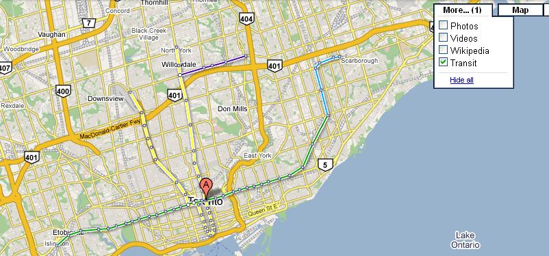
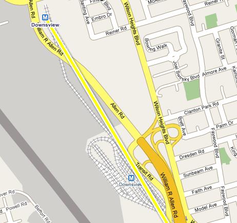
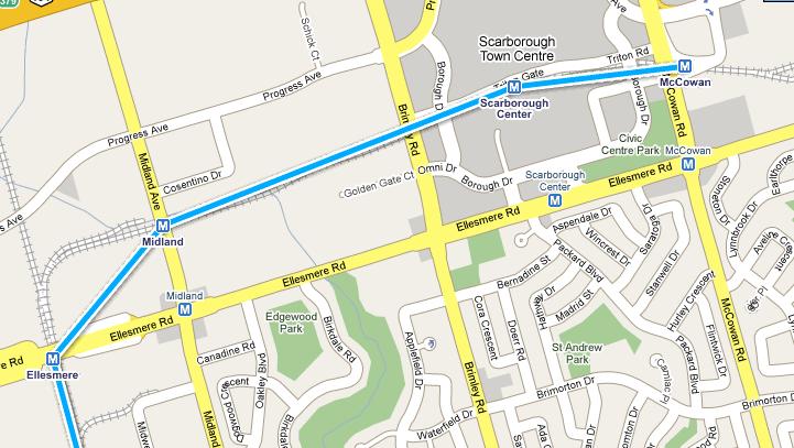
Click on the "More" button in the Google Maps display and check on "Transit" to open the subway map. The map is entirely made up of straight lines, and does not replace the stations placed earlier on Google Maps, so you'll be able to see how far the Google Map station location is from the actual location.

3251187755_7f6c4624b8_o.jpg


3251187817_83e6c1a691_o.jpg


3252013834_610fc49e63_o.jpg
 
typical of google results to be soo wacky!

heck, you try to search for irrigation systems and you'll probably get back some really strange porn for results.
 
The TTC is now on Google Transit! Big news! I haven't tested it too hard, but all the suggestions it made were reasonable. GO, YRT, and HSR were all already on the system. Interestingly, I requested a trip within Toronto where I know that a TTC+GO trip can save you half an hour (but cost 3 times as much), but all the suggested routes were TTC-only.

Torontoist
 
Google only updates their maps a few times a year, so don't expect the bus stop drawings to appear for quite some time.
 
Used it today - not bad.

I checked out how to get from Avenue and Roselawn to Laird and Wicksteed. Instead of telling me to take the bus to the subway, and onto another bus. It told me to get off at the last stop before the subway, and cross the street to the first stop the second bus stopped at leaving Eglinton station.

Hey, it's all free, and more intuitive than TTC's trip planner!
 
If you have a smartphone (at least on the Android version), you can see even more route suggestions by selecting "view later/earlier departures", plus you can see the last available trip for the day as well.

Playing with it, there was one point where the TTC did suggest a potentially better route. Seeing the Star this weekend did a test of how long it takes to get from Islington and Finch downtown, I wanted to see what the trip planners suggested (they took the Islington bus to the subway, across to Yonge, down to King, and walked from there). Google Maps suggest going across to Kipling and taking the bus to either Etobicoke North (1 hour, 9 minutes) or Kipling GO station (1 hour, 18 minutes), or taking the Islington bus to the Wilson bus to the subway and taking the 501 to Queens Quay (1 hour, 34 minutes).

The TTC trip planner's first suggestion is to take the Finch bus across to Dufferin and then take Dufferin bus down to the subway (1 hour, 19 minutes - a York University Rocket would work as well, though it would require crossing to the north side of Finch). So if you are going to be taking the TTC only, this would be the fastest way.

But for the most part, it is fantastic!
 
Last edited:
Google Transit also made it to Brampton Transit recently.

It works very well, but the amusing part is that the 200-series routes, which in Brampton are now the high school specials (they used to be in the 80-series) are shown as light rail.

Here's the routes from Yonge and Finch to Queen and Main in Brampton.
 
Last edited:
It's been on for several months now. You know how we Bramptonites (and associate Bramptonites) like to fly under the radar!
 
MiWay/Mississauga Transit is now also in, but the bus stops aren't in though. Only Oakville Transit, Milton Transit, and Durham Region Transit are the ones that don't have a Google Transit planner in Metrolinx's mandate area. I found this out when I was browsing directions to the Meadowvale Theatre, then route 48 just appeared. I was a little surprised.

http://maps.google.ca/maps?f=d&sour...644699&spn=0.131088,0.257149&t=h&z=12&start=0


http://maps.google.ca/maps?f=d&sour...670792&spn=0.130984,0.387955&t=h&z=12&start=0

 
It's starting to become a useful region tool.

There's still some pretty good bugs though ... catching a mid-day GO Train from Oshawa GO to Oakville GO still says you have to do a 62 minute change at Union Station - instead of just staying on the train.

Which makes it difficult to use it to plan trips from Scarborough to Port Credit.
 

Back
Top