News   Apr 19, 2024
 124     0 
News   Apr 19, 2024
 550     0 
News   Apr 18, 2024
 1.2K     2 

GO Transit: 50 Possible Sites for new Stations

The issue seems to be the lack of a good masterplan to guide the redevelopment. Really need to step back and rethink the whole area south of the Queensway.
That's exactly what brought Humber Bay to what it is today, a failed community with a lack of proper planning oversight. Things would have been dramatically different if Waterfront Toronto had the opportunity to have oversight over the development over the area, but of course that would have cost hundreds of millions more which they did not have at their disposal at the time.

The whole road network needs to be re-thought and the area certainly needs a GO station. Having 2 stations like a few people have been saying would be overkill and its something Metrolinx would probably never consider (remember it was hard enough even convincing them to add a station around Park Lawn).
 
Some outside the box ideas to improve local connections;

Lay new streetcar track down Mimico Ave / Royal York to Mimico GO Station = ~1,000m of track + new loop at Mimico GO
Lay new streetcar track on Burlington street north to the rail corridor, dive under the corridor and end in a new loop at Mimico GO = ~800-1000m of new track + grade separation + new loop at Mimico GO
Lay new streetcar track on Burlington St north to the rail corridor, head west down Manchester street, and end in a new loop at the Blue Goose Tavern = ~1000m of new track + expropriation of Blue Goose Tavern

These would be accompanied by a disentangling of streetcar services. 501 would pass westbound through Humber Bay and terminate at Mimico GO. 508 would serve Long Branch loop to Mimico GO loop.
 
Some outside the box ideas to improve local connections;

expropriation of Blue Goose Tavern

Whoa. That's sacred ground...... ;-)

Seriously, there is plenty of room for the GO station north of the Christie lands. Take the streetcar along the north side of the GO line, down the back of the existing Sobey's plaza - which is badly placed, in that it can only be reached from the condo wasteland by car - put the streetcar-GO interface on the north side just east of Park Lawn. Put the bus loop there also. Turn streetcars south on Park Lawn, and put the short turn loop down at Park Lawn and Lakeshore. (That way, you don't force a big redesign for streetcar routing and turnaround.) Extend the Runnymede S9uth bus west to the Go station. Route the Stephen Drive branch of the 66 bus Stephen Drive past Sobey's and then back to the GO stop. Build a short bit of busway across the creek to connect to Grand Avenue, and service the Mimico area that way, maybe all the way to Sherway or up to the Subway.

- Paul
 
I was thinking more like Queensway to the Lake. Etobicoke Creek to Humber. Where's the high-order transit. Etc.
 
Take the streetcar along the north side of the GO line, down the back of the existing Sobey's plaza - which is badly placed, in that it can only be reached from the condo wasteland by car

There is a very well used pedestrian walkway adjacent to the streetcar tunnel under the Gardiner, though there is far less reason to bother visiting Sobey's now since a very large Metro has opened up in the 'wasteland'.
 
These are exciting times for GO expansion. RER can act as almost a DRL west, although the rail lines still don't serve King and Queen Streets directly for the most part. Still, huge improvements are coming.
 
The 2-3 minute dwell time for the trains is rather high (esp. relative to the amount of time saved by electrification) - perhaps they should look at cars with more than just two sets of doors to further decrease boarding/egress time.

It's mainly due to the need to slow down and accelerate again I imagine.
 
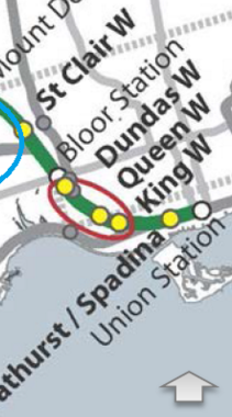
Please, dont forget Queen West @ Dufferin,
lots of density and more than enough room to put a station:)

Anywhere in the general area really....but the closer to King it is, I think the better.....aside from serving the density in, both, the Queen and King west areas, the new station will serve as, effectively, an "exhibition north" station and provide people attending events at the Ex/BMO/Ricoh/Ampitheatre a viable public transit option....and present the new ReR services with an off peak ridership driver....getting ridership in the offpeak is a key factor in making ReR a success.

The further north you move from the Ex area the less likely a new station will provide that service....so a station down by King/LV area might serve the Queen/Dufferin area but I am less convinced a Queen/Dufferin station will fill that "exhibition north" mandate.
 
I really think you'd end up tunnelling it up Don Mills (with stations at Eglinton and Lawrence), maybe double tunneling with a Don Mills subway, and then punching it back out onto the rail ROW just west of Don Mills.

If you were to do that, it begs the question of whether you NEED a relief subway all the way to Sheppard....take care of the Line 2 offtake with a southern relief line, and then take care of the north-of-bloor on an upgraded Richmond Hill line.

Richmond Hill line and DRL-Long serves different commuters and different commutes. Both can co-exist without cannibalizing each others ridership, especially if fares are separated.

But, we can save costs by using the same tunnel for Richmond Hill line and a DRL line on Don Mills.
 
Please, dont forget Queen West @ Dufferin,
lots of density and more than enough room to put a station:)

You only got land there for a single platform for tracks 1 & 8 only. Track 1 is the Barrie line and 8 is the Milton line. They will be short platforms.

To get any other lines to use that station will require a lot more crossover and a dispatching nightmare.

King can only support track 8.

Doing one at Dundas can be done for all lines, but require access from the overpass with elevators for each platform and stairs similar to West Harbour.

I recommend that you visit these area personal to see what is really there now.
 
Noticed that my post about the Gage GO station in Hamilton (listed in the longer version of Metrolinxs' list) wasn't moved here.

Perhaps this thread is only for the shortlist, however, I thought this will be interesting as it is shortlist material (if it weren't for difficulties extending electrification into Hamilton at the moment). As Toronto needs to visit Hamilton's stadium more easily:

So here it is an updated version moved here:

gagego-png.54964


The City of Hamilton purchased land near the GO station in the preliminary list by Metrolinx. It's land very close to the new stadium in Hamilton. Perfect place for an events platform. I've emailed Lee at Metrolinx to let him know.

It's not in the shortlist mainly because they're only looking at infills up to Aldershot for this current 10-year RER cycle. However, an infill between West Harbour GO and Stoney Creek GO will eventually be needed someday, especially if electrified RER is extended from Aldershot to Hamilton (say, in 15 years, perhaps, as RER Phase 2).

Also, local city councillor Sam raised a motion to do a Grey Cup at the Hamilton Stadium. To them, I suggested that they build a cheap Exhibition-style unsheltered GO platform near the stadium. Apparently, Hamilton purchased land next to Gage on the railroad route between West Harbour and Stoney Creek. Matthew Green (my ward's councillor) is also aware of this idea, from earlier. Originally the stadium was supposed to have been built at West Harbour, near the new GO station. However, while we needed West Harbour over the long term anyway, the stadium wrong can be righted -- with another (albiet barebones) station.

The distance between West Harbour GO and Gage GO is actually bigger than the distance between Union and Exhibition GO. And at more than 3 kilometers, it's bigger than the typical infill station spacing! It would be worthwhile even without electrification, especially if this is an events-only platform (initially) like Exhibition GO was.

For less than $1M, a temporary unsheltered asphalt platform (to serve events only) could occur only on the south side of the tracks -- just like the first temporary Exhibition platform (it was also originally to serve events only too!). No shelter, no underpass, no overpass. Just a simple cheap platform, with ticket/Presto vending machines.

The land is now owned by the city (and, apparently, more land than the land used by West Harbor GO). City of Hamilton bought the old glass plant at Gage & Lloyd, which abuts into the railroad. It acted as parking for PanAm, and will be turned into soccer fields, but there's plenty of land to also fit a simple Exhibition-style pedestrian platform too -- without even sacrificing any planned soccer field.

In this case for a temporary events-only platform, no pedestrian overpass is needed, if a bidirectional siding is built to the south -- or possibly using rail they plan to install south of the CN trackage between West Harbour and Stoney Creek GO.

It is only 2-3 long blocks away from the new Hamilton stadium, a 5 minute walk.

Events include:
- TiCats football games
- Argonauts, whenever they need an alternate GTHA stadium
- Future Grey Cup (the motion raised by Sam)
- Future version of World Music Festival at Gage Park (10-15 minute walk south)

Note: Since this was written, Lee has thanked me for flagging this to Metrolinx's attention -- their department may not have been aware that City of Hamilton now owns lands adjacent to the Gage GO station.
 
Last edited:

Back
Top