News   Apr 25, 2024
 393     0 
News   Apr 25, 2024
 1.1K     4 
News   Apr 25, 2024
 1.1K     0 

Future Toronto 3d model

I've noticed this colour coding is very similar to how skyscraperpage.com does it. My fantasy would be for that website (or this one) to add a web program using java or something where we can view the sketchup ourselves like in google earth and pay insertnamehere to run it/add new buildings. And if it allowed you to filter the model to show only under construction, only built, or only proposed, etc. that would be a great future project. Maybe even use kickstarter to get it off the ground. HELL, I'd pay 10 bucks for that.
 
The main problem with that is the lack of a web application. This is done offline and if someone were to wish to view it, there is no "google earth" web app that would allow them to do so without downloading the .kmz files and uploading them to the google earth installed on their hard drive. You would then lose all customability for filtering colours.

I currently have the model split into 8 files. The original base models are split into 3 and include all the big projects that were announced before Februaryish. (There are a lot that have been announced since) I have those files split by location, with a "south section" being any project south of Massey tower, I have a "middle section" with projects from Massey tower to around Five condos, and a "north section" with all the projects north of that. I then have 3 additional files which contain more obscure proposals and any new projects announced since I started the model. These are just placed randomly throughout the city, as I just created a new file whenever the last one started to get slow. I also have 2 indipendant files for the yonge eglinton area and the Humber bay shores area.

Simply, it would take me a LOT of time to move the buildings one by one from each file to another to allow me to filter them accordingly. Probably a good idea though. Now you have me thinking... Well there goes the weekend.. Lol
 
[video=youtube;BmaEghocNCk]http://www.youtube.com/watch?nomobile=1&v=BmaEghocNCk[/video]

very cool, thanks for that video. I feel like that previous idea I mentioned could only work if the revenue could be generated (via advertising, or in the improbable event people actually pay to subscribe/have access), it could require a full month or more of someone working full time on it.(and obviously would require a high degree of skill as well) so would need to be left for someone with a serious passion for urban development.

It probably couldn't even use google earth since that's already owned by google and is very complicated and probably requires a hundred staff to support it, it might require a more simple program with spatial boundaries of only central Toronto and less to no labeling.

Another idea that might be an easier, but less impressive tradeoff would be to have an interactive program with a decent variety of high profile skyline views in photo format, with the under construction and planned/sales/approved renders pasted in, the filtering I mentioned in the previous post would still be possible there would just be no freedom of movement in the pictures like there is in 3d models so not everyone would be able to see the exact view they want.

So by all means, if anyone is reading this and thinks, "hey that's something I would like to do" feel free to run with the idea it's probably been thought of a hundred times before I mentioned it and I have no claim to the idea, only a desire to see it made into reality and a willingness to pay money for access.
 
Last edited:
The key thing with Google earth is that it already has thousands of buildings downtown in their database that you would have to remodel if you wanted to create an independent program. quite frankly I think a web application using 3D modeling is just simply out of reach of current computer capabilities, or else i feel Google would have implemented it into Google maps already. I know there is a small model of downtown currently somewhere that is bloor to front and Yonge to university. its not a sketchup file however, which puts it out of my capabilities.
 
That video was awesome...thanks for that. Yonge st. just north and south of Bloor looks amazing. If all those get built, the canyon will be awesome. I'm not even sure I know what many of those reds are.
 
Is it at all possible to convince you to possibly do a eglinton/ allen road north to shepard and then west to keele fly view which would include all the Lawrence heights redevelopement, the station condos, glemercy park condos, and downsview park condos?
 
Kevin-Butler-Mind-Blown.gif
 
Hey, great coverage in the Toronto Star today.....congrats, insertnamehere!! :cool:
 
Good job, Cale!

From the Toronto Star today:
http://www.thestar.com/news/gta/article/1296622--growing-up-visualizing-the-future-of-toronto


Growing Up: Visualizing the future of Toronto
Published on Sunday December 02, 2012


Alyshah Hasham
Staff Reporter


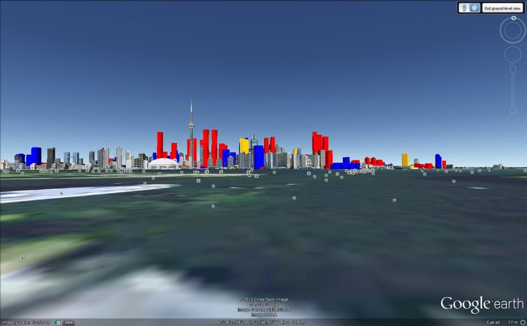
Behold the Toronto skyline of the future.

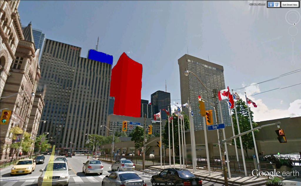
With the click of a mouse, Cale Vanderveen swoops through the Yonge St. canyon. With another, he pivots around the CN Tower, past the top of the proposed casino complex.

The 17-year-old high school student from Uxbridge is demonstrating a 3D model of the downtown core he built on his laptop using SketchUp, free 3D modeling software formerly owned by Google.

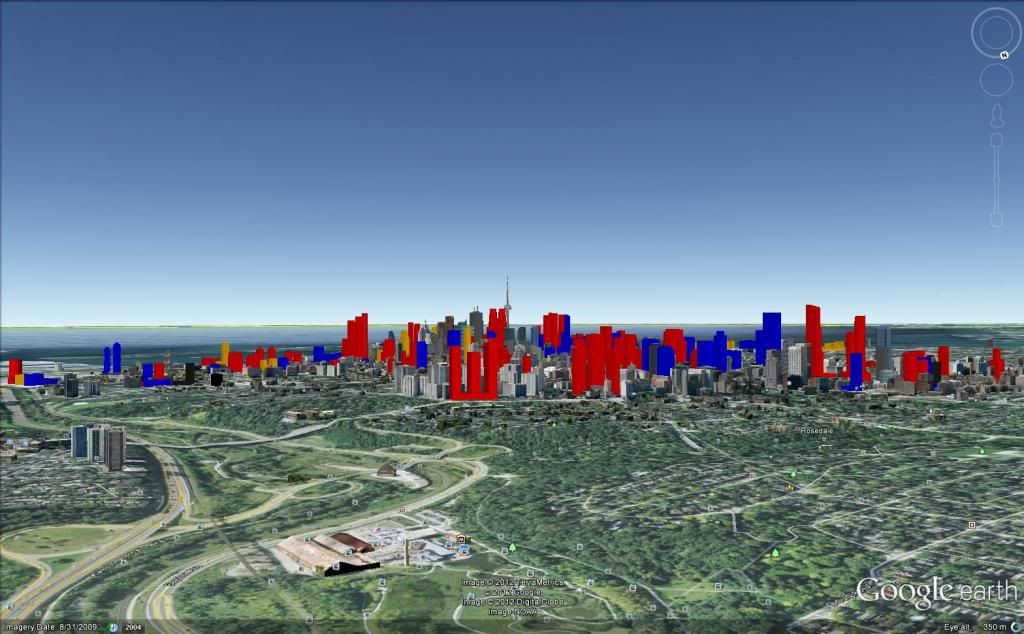
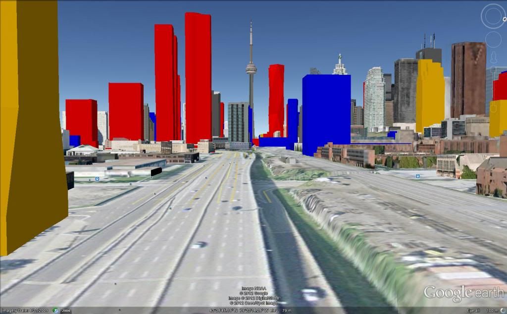
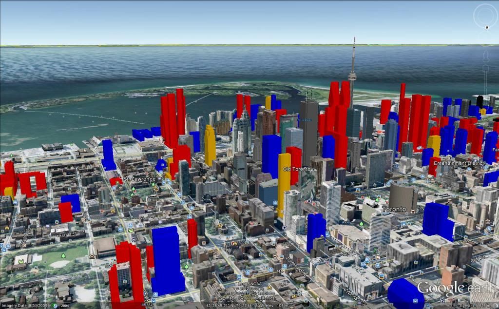
The proposed buildings are constructed in SketchUp and placed in a model of present-day Toronto from Google Earth. The result is an interactive 3D model that shows just about every future structure currently in the works, from the newly announced Gehry-Mirvish towers to those well under construction, each building colour-coded to show its stage of development.

A flyover video tour of the model Vanderveen put up on YouTube is a rare glimpse of the city to come.

It took Vanderveen about three months to construct the model in his spare time.

“I guess I just wanted to visualize the city,” he says of his hobby.

The aspiring architect became fascinated with the skyscraper boom in the city about two years ago, haunting forums on sites like Urban Toronto and Skyscraper Page. When he saw the plans for Trump Hotel, he decided to use SketchUp to see what it would look like.

Then he constructed the waterfront development … and continued until he’d mapped the entire downtown core — with a bit of Yonge and Eglinton to the north and Humbertown to the far west.

The model is not perfectly accurate, says Vanderveen. He gets most of his data from building permits and development applications available through the city’s Open Data program. Sometimes he estimates pieces from developer marketing images.

Even so, “it’s very impressive,” says Frank Lewinberg, a partner at planning and design firm Urban Strategies. “Anything that encourages public awareness and engagement with what’s happening in the city is a wonderful thing.”

But publicly sharing Vanderveen’s visualization of what the city is becoming is a challenge.

Vanderveen’s model exists only on his computer, shared publicly only through that virtual-tour video.

The same is true for the City of Toronto building model, a behemoth begun in 1987 in a program called MicroStation.

It now features 100,000 of the city’s one million structures, shown in painstaking detail, down to the slopes and dips of the terrain, says Carolyn Humphreys, program manager of the city’s graphics and visualization department.

It is the most accurate model for experiencing Toronto’s future, often used in sun-shadow testing for new buildings or sold in smaller bits to architecture firms, developers and others who need visualizations.

What’s holding the city back from sharing the model more broadly is the sheer size of the files involved, Humphreys says. But she has been considering other ways to get the public engaged in visualizing the city’s future.

She once proposed that all building applicants should make models of their projects available to Google Earth so, “you and I, at 3 in the morning, wondering what this building is really going to look like in my neighbourhood, could go in (to Google Earth) and have a look.”

The city is working on a plan to upgrade the physical model in City Hall and add a walk-through or animation of the 3D model on a screen behind it (and seeking sponsors).

Meanwhile, for Vanderveen, the near future is looking up. Interest sparked by a blog post about his model at Canadian Business last month won him a summer job at RealNet, a real estate investment research company.

“It’s just a hobby that’s exploded,” he says, laughing. “It’s kind of cool.”
 
thanks! trying something different, i tried to integrate it into a google streetview image with an extremely horrible cutout job done on paint.net:

afinal_zpse569a84b.png
 
Last edited:
Insertnamehere, if you change them to grey before you try to copy them into a streetview, you may find it a little easier to adjust the image and add some touch-ups. Greyscale is always a little easier to deal with on a colour image! Looking good though!
 

Back
Top