News   Jul 12, 2024
 798     0 
News   Jul 12, 2024
 725     0 
News   Jul 12, 2024
 305     0 

Evocative Images of Lost Toronto

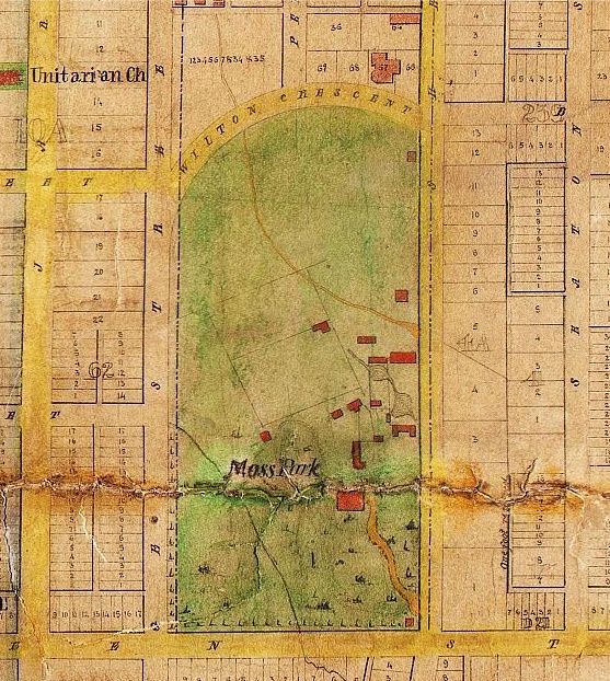
My god! What a come-down for poor Wilton Crescent! The more modern photo (from 1980s) of 247 Dundas East shows a building very similar to what is there now. (See Google Streetview). It was recently renovated yet again (the reno was still in process when the streetview photo was taken) and the 'shed' at the corner of Pembroke Street and Dundas East is now a restaurant.

Just found a beautiful 1862 map on my new favourite web-site (thank you, wwwebster): http://www.toronto.ca/archives/map_atlases.htm

Wilton Crescent formed the northern boundary of the Moss Park estate:

1862mosspark-1.jpg
 
Thanks, deepend, for the photos. Here are a few more that have the same effect on me:
Royal visit at King & York (Globe & Mail Building behind):
globebuilding-2-1.jpg

Does anyone know where there are images of the old Globe and Mail building? I've tried Googling it but next to nothing shows up.
 
Last edited:
Canadiana.org and in particular its Canadiana Discovery Portal have recently added links to several digitised albums of City photographs. Access is explained by them as:

"The Canadiana Discovery Portal ( http://beta.canadiana.ca/ ) continues to add new and interesting content to its database. Most recently, the National Gallery of Canada has contributed a collection of digital photo albums of Canadian cities, mostly taken in the early 20th century. This is just the first of several digital collections that the National Gallery intends to make available through the Portal. You can view this collection, by searching the term “albums” in the Canadiana Discovery Portal and choosing the National Gallery of Canada as the contributor.
Other recent additions to the Portal are a collection of over 5000 photos and postcards from the Calgary Public Library and an historic newspaper collection from Manitobia with issues going back to the early 20th century."

I think I have seen most of the Toronto photos before but ...
 
Prohibition 1916

There's always something to march for (or against) isn't there?

Prohibition1916.jpg
 
Last edited:
Don River - new pathway

I've never before seen such a clear depiction of the 'straightened' Don River.

DonRiver-straightenedaerial.jpg
 
Last edited:
Do we know if this is Front St. - EAST or WEST?

FrontStrearof5121914.jpg


Toronto Harbour 1918 - from roof of Harbour Commission Bldg.

TorontoHarbour1918-ArthurBeales.jpg


Sunnyside Dr. at Keele 1922

SunnysideDriveatKeele1922.jpg
 
Last edited:
512 Front Street. - "Do we know if this is Front St. - EAST or WEST?"


According to MIGHT'S TORONTO CITY DIRECTORY - 1910:
(N/W corner - Draper & Front Street West.)

512 Front Street West.
Evoy, Mrs Mary J.
Evoy, Matthew.
Alleyne, Evans.

EAST FRONT N/A. (No housing.)

Regards,
J T
 
Last edited:
512 Front Street. - "Do we know if this is Front St. - EAST or WEST?"

(N/W corner - Draper & Front Street West.)
512 Front Street West.
Evoy, Mrs Mary J.
Evoy, Matthew.
Alleyne, Evans.

Thanks for that info, JT.
Hope I can do a 'Then & Now' some day.
-- unless someone beats me to it!

FrontStrearof5121914.jpg
 
"Hope I can do a 'Then & Now' some day." QUOTE Goldie.


Draper Street is a real gem, however as in the above, an additional vista presents itself: N/E corner of Welington & Portland Streets.

There is a photo in ithe Toronto Archives of a house with an eastern walkway, three properties east of Portland Street with gingerbread/

wood shingles on the porch that continues to this day untouched, except by years passing. This property has long been as a hulk,

with no change even unto a single miss ing shingle on that porch; a tyme capsual as it were. As with any? architectural photo,

winter is the best tyme to view, as the foliage is at it's least invaisive/obstructive. Entrance to this property is by a front gate

or an open area to the rear, neighours being as same.


Regards,
J T
 
Last edited:
The house which I referenced is of the left hand; there must be a second photo showing more of the porch area.

Housing to the right is still existant but much "renovated", modern.


Regards,
J T
 
We were discussing ruins on the Now and Then thread. Here's an interesting shot of the Armouries being demolished while the New City Hall rises beyond:

2084600504-1.jpg
 
Front & Yonge:

s0574_fl0092_id491132.jpg


f1244_it7189.jpg


Original rendering of the McMaster Warehouse (1871). It would appear from the 1930's photo that the building was doubled in size along Front at some point (pic and description from Toronto No Mean City):

mcmaster-1.jpg


mcmaster-2.jpg


Farewell:

mcmaster3.jpg
 
Last edited:

Back
Top