News   Apr 18, 2024
 359     1 
News   Apr 18, 2024
 1.4K     3 
News   Apr 18, 2024
 367     0 

Eglinton Avenue Extension

Lone Primate

Active Member
Member Bio
Joined
Aug 16, 2007
Messages
987
Reaction score
145
Location
Don Mills Willowdale Park Forest something I dunno
Someone asked a few days about about shots of Eglinton and Don Mills. Well, I don't have that specifically, I don't think... nothing about it every got me looking it up... but I have shots of the ends of Eglinton that were connected in the mid-50s by what was then termed the "Eglinton Avenue Extension".

1315403492_9244e8451c_b.jpg


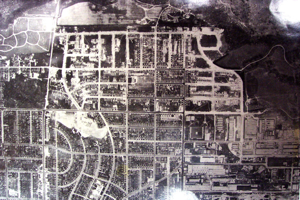
This is the west end of Eglinton in 1947... it's one of the plates you can't freely access anymore, so I'm glad I took this when I did. Eglinton is dead centre on the horizontal, and ended, at the time, at Laird, though you can see it's been roughed in Brentcliffe in conjunction with the expansion of the subdivision. To the east is the Don River. Leslie Street didn't come down to Eglinton at the time as, of course, there wasn't an Eglinton to get to yet.


1314500857_e5493ddc6f_b.jpg


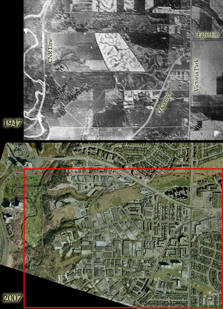
At the other end, Eglinton ended at Victoria Park. This, again, shows a view from 1947, contrasted with a contemporary view. The red-bordered area shows the overlap.


1315398118_861335ad93_b.jpg


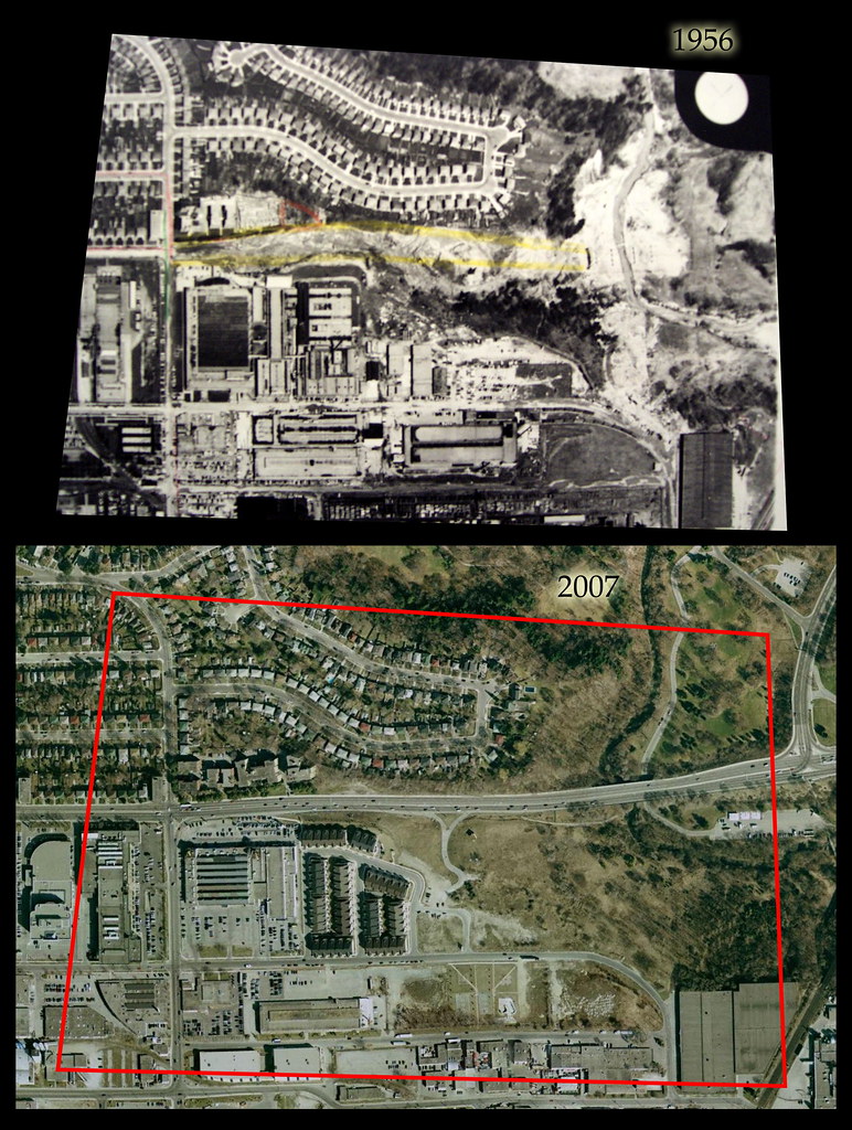
Back to the other end. By 1956, the extension itself was under construction. You can see the abutments for carrying the bridge across the Don are already in place. A map I have dating from 1959 shows the extension complete and in use.
 
It must have been tough crossing the Don River back then - St. Clair didn't, Eglinton didn't, and Lawrence was an obstacle course. But at the same time, there wasn't (and arguably still isn't :)) a reason to go anywhere east of Leslie.
 
Presumably, the main W-E route was Eglinton-Laird-Donlands-O'Connor-Eglinton (i.e. over two interwar viaducts). Other than that, the next "major" route north might have been...Hwy 7...
 
Presumably, the main W-E route was Eglinton-Laird-Donlands-O'Connor-Eglinton (i.e. over two interwar viaducts). Other than that, the next "major" route north might have been...Hwy 7...

I guess it would depend on how you were defining "major". In terms of just getting across the Don at some point, you could have done it on Lawrence to the north... On the other hand, if you mean a road that didn't have some kind of similar discontinuity in it, I guess you'd be right. Lawrence broke, and still breaks, at Bayview. Ellesmere/York Mills/Wilson broke at Yonge... Sheppard was a good bet, I think; it's been continuous from end to end for a long time... though you might consider its ending at Weston the way it still does in and of itself a break. Finch ended at Islington and then had gaps in it right up till the 90s as they built new bits and pieces of it in the west end, and it had a number of major jogs in it in the vicinity of the North York-Scarborough frontier. Steeles broke at the Humber River till only about a generation ago. So I suppose "major" depends on how long your trip was. :) Though Hwy 7 would fit the bill in pretty much anyone's book prior to the 1950s.
 
Aside from the Vic Park jog (when was that eliminated?), how "improved" was Sheppard, considering it wasn't part of the provincial highway system? (And when was the "Lansing Cut-Off"--the Sheppard diagonal leading into Port Union--built?)
 
Aside from the Vic Park jog (when was that eliminated?), how "improved" was Sheppard, considering it wasn't part of the provincial highway system? (And when was the "Lansing Cut-Off"--the Sheppard diagonal leading into Port Union--built?)

Well, given we know it bridged everything east of the Humber all the way to the Rouge, I'd guess it was at least as passable as anything else at the time. Lansing Sideroad existed for a long time before it was subsumed into Sheppard Avenue in the 1960s. I don't know when it was built precisely, but I know it existed in the time frame we're talking about, just prior to the construction of the Eglinton Avenue Extension. I guess if you were doing anything in "town", you'd probably be using Bloor anyway at the time. If you needed to traverse lower York County, Sheppard would have been a good choice. Getting anywhere long range before the 401 was built, Hwy 7 would have been your best bet, I'd say.
 
I presume the main excuse for Sheppard's stature back then was Agincourt, back when it was the main population centre in N Scarborough...
 
I presume the main excuse for Sheppard's stature back then was Agincourt, back when it was the main population centre in N Scarborough...

It's hard to say how these things work... chicken and egg time: which came first? Sometimes settlements promote road building; sometimes useful road arrangements invite increasing settlement. Often, I guess, they feed on one another.

I'm not sure just why Sheppard would have been essentially complete from Weston on into Durham so long ago, when most parallel roads had gaps. It might just have been as simple as the fact that it met all its rivers east of the Humber at junctures with slopes people back then considered relatively unchallenging to bridge building, and so it was a good street to use. I imagine it would have been fairly pleasing to know there was something you could just get on and roll with, without having to remember which other roads took you where.
 

Back
Top