News   Nov 18, 2024
 1.4K     1 
News   Nov 18, 2024
 678     0 
News   Nov 18, 2024
 1.7K     1 

Cycling infrastructure (Separated bike lanes)

I think the confusion will be that based on the citiy’s studies, speeds on birchmount exceed the speed limit(they’re more akin to an arterial as opposed to a local street). So it’s unlikely this treatment will work as expected unless there are additional methods of calming traffic.

This is partly caused by this:

1717780220793.png


This is only a few years old, they rebuilt the slip lane and retained it.

To get a slower speed on Birchmount here, you need the slip lane removed, and force cars to slow/stop to make a hard right onto Birchmount.
 
Last edited:
This short street segment sees a surprising amount of traffic, it may be used for purposes of accessing Variety Village (off Danforth), Scarborough Gardens Arena, the Community Centre, the Catholic school, houses fronting the street, flow-through from Birchmount/access to Danforth/access to Kingston Rd; as well as traffic coming off Hollis (the extension of Gerrard/Clonmore)

You've got a lot of of pick-up/drop-off activity, lots of turning movements.

I just think drivers here would find this design confusing/challenging.
Taking a second look, I may be mistaken, but are they referring to only that really short section south of Kingston Road to Springbank Avenue?
 
Taking a second look, I may be mistaken, but are they referring to only that really short section south of Kingston Road to Springbank Avenue?

I think you're correct. Because it was presented as B1 and B2 I thought it of it as either/or options. I also knew Birchmount in the Kingston to Danforth segment was being done. Didn't really occur to me to consider this sliver south of Kingston.

That said, I'm still going to say, I'm not sold on the idea here.
 
I came across this in my neighbourhood the other day and thought I would share:

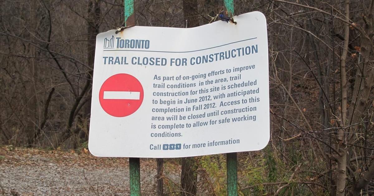
13 years ago signs went up on Bayview for work on the Burke Brooke Ravine Trail, which would connect Sunnybrook Park to Sherwood Park in North Toronto.


1717958453339.png


And little if anything was ever done. The trail from Sunnybrook ended abruptly in the ravine and if you jumped the chest high fence you were met with a very rough human foot made trail.

Welp, fast forward to 13 years later and it looks like work has actually started on this trail.


At the same time, at the end of the video you can see a huge landslide around the Toronto Rehabilitation Institute, and a drainage pipe is even sticking out 5 feet into the air. I hope this wasn't caused accidentally by the construction below! I need to check out if the dotted trail to the south that is above the ravine has been washed out. My instincts tell me yes.

Anyways nice to finally see this work going on to connect the parks together in a nice way, however the section of Sherwood Park to the North of Mount Hope Cemetery does not allow bikes (and its got a ton of wooden stairs anyways, it's completely unusable to bikes anyways) I would like to see them create a more wheelchair accessible/biking trail along the floor of the ravine through that area that would properly link up Sherwood Park to Sunnybrook.
 
I came across this in my neighbourhood the other day and thought I would share:

13 years ago signs went up on Bayview for work on the Burke Brooke Ravine Trail, which would connect Sunnybrook Park to Sherwood Park in North Toronto.


View attachment 570895

And little if anything was ever done. The trail from Sunnybrook ended abruptly in the ravine and if you jumped the chest high fence you were met with a very rough human foot made trail.

Welp, fast forward to 13 years later and it looks like work has actually started on this trail.


I don't think so.......... I will explain below.

At the same time, at the end of the video you can see a huge landslide around the Toronto Rehabilitation Institute, and a drainage pipe is even sticking out 5 feet into the air. I hope this wasn't caused accidentally by the construction below! I need to check out if the dotted trail to the south that is above the ravine has been washed out. My instincts tell me yes.

Your instincts are off....... (see link)


From the above:

1717959844606.png

*****

1717959901204.png


****

You're almost certainly looking at construction access for TRCA equipment and personnel, not 'trail'

For those curious about the erosion, picture from the above link:

1717959994887.png

Credit: TRCA

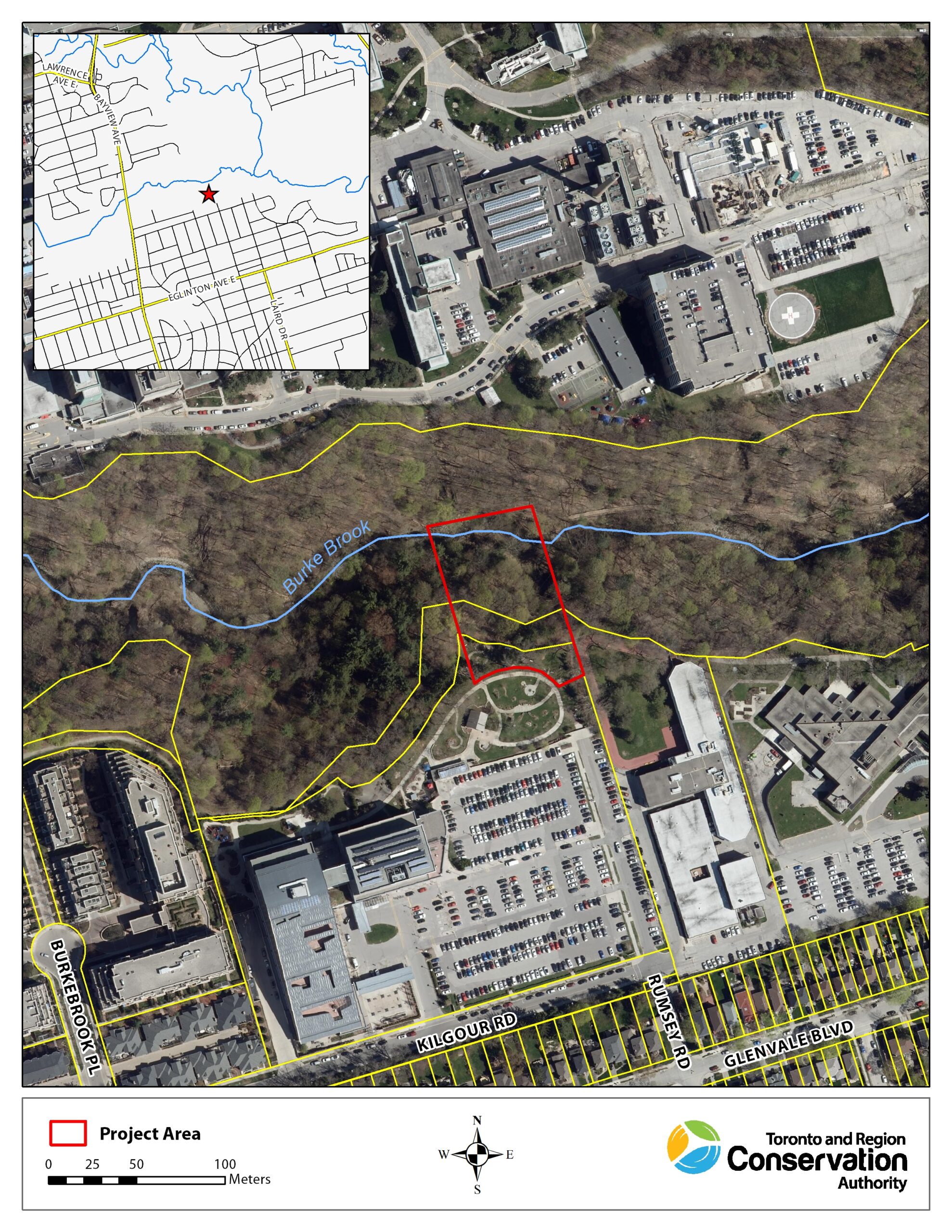
Aerial View:

1717960066396.png

Credit: TRCA


Anyways nice to finally see this work going on to connect the parks together in a nice way

Sorry about the bad news.


, however the section of Sherwood Park to the North of Mount Hope Cemetery does not allow bikes (and its got a ton of wooden stairs anyways, it's completely unusable to bikes anyways) I would like to see them create a more wheelchair accessible/biking trail along the floor of the ravine through that area that would properly link up Sherwood Park to Sunnybrook.

There will not be a bike trail through Sherwood. Its designated an ESA. (Environmentally sensitive area). The boardwalks are to keep hikers from trampling plants. Paving a 4M wide trail on that terrain is a non-starter.


***

I just had another look at the Toronto Trails Strategy which I posted on previously. Burke Brook is not in the near to medium term plans.
 
I don't think so.......... I will explain below.


Your instincts are off....... (see link)


From the above:

View attachment 570900
*****

View attachment 570901

****

You're almost certainly looking at construction access for TRCA equipment and personnel, not 'trail'

For those curious about the erosion, picture from the above link:

View attachment 570902
Credit: TRCA

Aerial View:

View attachment 570903
Credit: TRCA


Sorry about the bad news.


There will not be a bike trail through Sherwood. Its designated an ESA. (Environmentally sensitive area). The boardwalks are to keep hikers from trampling plants. Paving a 4M wide trail on that terrain is a non-starter.


***

I just had another look at the Toronto Trails Strategy which I posted on previously. Burke Brook is not in the near to medium term plans.

Ha! omg wow. Thanks for the information. Its the other way around, the erosion caused the "trail"

It's crazy to me that they wouldn't just convert this path for the construction equipment into a trail after they are done. I mean, a lot of the work is already done.
 
Ha! omg wow. Thanks for the information. Its the other way around, the erosion caused the "trail"

It's crazy to me that they wouldn't just convert this path for the construction equipment into a trail after they are done. I mean, a lot of the work is already done.

The contact info of the project manager, Daniel Dyce, is at at the bottom of the link I posted, give him a call or send him an email asking about that.

Its certainly plausible it could be retained, I just don't see any specific evidence that its planned.

But sometimes things like that do stick around. The very first leg of the East Don Trail going north from the forks, was built, as a dirt/gravel road, for emergency erosion control works.

It was never removed. It just dead-ended, and wasn't paved or made an official trail. But it is now being integrated into the East Don Trail, something like 20 years later.
 
Last edited:
The contact info of the project manager, Daniel Dyce, is at at the bottom of the link I sent you, give him a call or send him an email asking about that.

Its certainly plausible it could be retained, I just don't see any specific evidence that its planned.

But sometimes things like that do stick around. The very first leg of the East Don Trail going north from the forks, was built, as a dirt/gravel road, for emergency erosion control works.

It was never removed. It just dead-ended, and wasn't paved or made an official trail. But it is now being integrated into the East Don Trail, something like 20 years later.
Ok ill message them. Thanks

It would be silly to spend money to backfill it or something when it would be a great addition to the area.
 
A journalist asks the Mayor of Quebec City whether there should be a tax on winter cyclists as 6% of the snow removal budget is for bike paths.


For the click averse......

The long and short was the dumb question above.........

To which the mayor replied (my paraphrase) "and how do Motorists pay for their share of snow removal?"

The reporter said 'That wasn't my question'...

The Mayor then went on and said, "I know, but you're implying that its unfair that cyclists don't pay for snow removal on bike paths, and I'm asking how do motorists pay........ clearly through their property taxes
the same way cyclists do and pedestrians do.

Unless you know of something in the tax code that I overlooked that says cyclists are exempt from paying property tax, especially in the winter......"


* again, my paraphrase

*****

It was a good, straight-forward take down of an asinine question.
 
Last edited:
I think public ridicule is the appropriate response for such brazen public stupidity.
Was this a reporter from a reputable outlet? Or was it a "reporter" like the ones from Rebel whose only goal is to go viral with some stupid clip, in which case even this smack-down is a win for them.
 
Last week I decided to skip work for a couple of hours and go for a cycle around town. I rode up Parliament and then took the Bloor separated bike lane from Sherbourne to Ossington and then turned around and returned along Bloor to Parliament. And I have to say the conditions on the separated bike lanes, especially eastbound are terrible. There must have been at least a dozen construction or other obstructions, several forcing me into traffic or to merge with pedestrians.

What's the purpose of this map https://www.toronto.ca/services-pay...ocation=&lat=43.670867&lng=-79.390383&zoom=16 if it doesn't give us the status of the separated bike paths? Besides keeping some intern occupied.
 
Last edited:
Are there any plans for a better Beltline - Bayview connection near Brickworks? I ask because I encountered some marked cycle connections here that are notably dangerous. It seems like a pretty common desire path for northbound/southbound travel, since the two trails diverge more east/west once reaching this area. Now take a look below where some maps recommend crossing to bridge the trail gap.

Bike Share map:
IMG_1557.jpeg


Looking Southbound:
IMG_1568.jpeg


Looking northbound:
IMG_1569.jpeg


The Bayview MUP runs entirely on the east side of traffic. In this particular spot, the path splits from the road to travel underneath the Bayview Bloor ramps to DVP. Continuing to ride on Bayview (as is a suggested cycling route) would mean riding the shoulder with no barrier, crossing multiple slip lanes with 60+ km/h traffic and sight lines often reduced by twists in the roads and tree coverage.

Now I can’t see many mistakenly missing the safer route unless they’re coming from the Beltline trail. The only safe connection between these two trails requires a little detour into Brickworks followed by the signalled crossing at its entrance. It’s not obvious in the trail, the various cycling maps will convince you the shortest passage is in the middle of high speed traffic.

I’d like to contact the right people about correcting this on maps or improving the cycle network, but first I’d like to know if anyone has any more context I’m missing.
 

Back
Top