News   Apr 18, 2024
 316     0 
News   Apr 18, 2024
 2.2K     1 
News   Apr 18, 2024
 2K     4 

SmartTrack (Proposed)

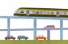
Does grade separated mean elevated? Or just beside the road rather than in the middle (which is the dumbest thing ever I should add, and should not have happened for the eastern portion of the Eglinton LRT)

And let's not forget what Metrolinx said around this time last year:

While overhead transit hasn’t historically been embraced here, Metrolinx CEO Bruce McCuaig says it “is one of the solutions we do need to think about for different parts of the system as we move forward.â€

It was rejected east of Don Mills for the Eglinton Crosstown. But there are plans for an elevated section in the West End, near Black Creek Dr.

“That’s an opportunity,†he said, “for us to show how we can build an elevated section of guideway in a way that fits into the community. One of the concerns in Toronto historically has been how do you integrate an elevated structure into the local community.â€

From here: http://www.thestar.com/news/gta/tra...ter_elevated_transit_isnt_always_smarter.html
 
Oh, whoops. I dunno why I thought they were hinting at all of the future Eglinton West portion potentially being elevated.
 
I have a feeling Go RER/SmartTrack will end up looking something like Sydney Trains (formerly CityRail) - a hybrid subway/commuter rail system with a mix of bilevel EMUs and DMUs running at (near) metro frequencies:


The network map kind of resembles our current GO lines:

View attachment 42688

Yikes.

That map is incredibly old. Plus there are no DMU trains operating metropolitan services in Sydney, Melbourne, Brisbane or Perth. Adelaide is in the process of electrifying its network (2 lines already completed). DMU services on metropolitan networks are only there as they're usually inter-city services which run beyond respective metro areas.

Most recent Sydney map:

sydney-trains-network-map.jpg


Sydney's building an isolated line (on that map in the north west) which will be fully automated and single deck (with the tunnels only capable of fitting single deck trains), the next phase will be to build a 2nd harbour crossing (SHB only has two tracks on its western side at present) and it'll cut through the CBD and out to the Bankstown line and that line is to be converted to the new standard. For want of a better term, North Americans would describe it as a 'subway' line.

A new government in Victoria and they've cancelled an inner-city east-west freeway tunnel and put the Melbourne Metro (rail) tunnel back in its rightful place. It's basically just another track pair crossing the centre of the city from the South East and heading west with new inner-city stations to the north west, north and south of the CBD (where all rail lines currently converge). New South Wales Gov might look at the same thing, but here rather than build a completely new standard of track, Vic Gov is going to be trialling a new signalling system / in-cab / no-blocks that you'd find in most modern 'subway' or 'metro' systems with a view to rolling out across all lines.

It's mainly just about squeezing capacity out of all lines. Max headways are about 3-4 minutes at present with the patchwork of different signalling systems at present (don't ask), that'll move to 2-3 minutes with the new signalling system.
 
Looks like a big Regional Express Rail announcement is happening tomorrow, which will help push SmartTrack down the line. Here are the first lines that are rumoured to be electrified on a map I made, along with an article about the announcement. Article: http://www.thestar.com/news/gta/tra...marttrack-a-little-further-down-the-line.html Tweet: https://twitter.com/Patrick4ONT/status/588876687342874624

Purple lines are the first phase of RER, which include John Tory's SmartTrack routes (except the Eglinton spur):
GO RER phase 1.jpg
 

Attachments

  • GO RER phase 1.jpg
    GO RER phase 1.jpg
    854.3 KB · Views: 1,821
Last edited:
Looks like a big Regional Express Rail announcement is happening tomorrow, which will help push SmartTrack down the line. Here are the first lines that are rumoured to be electrified on a map I made, along with an article about the announcement. Article: http://www.thestar.com/news/gta/tra...marttrack-a-little-further-down-the-line.html Tweet: https://twitter.com/Patrick4ONT/status/588876687342874624

Purple lines are the first phase of RER, which include John Tory's SmartTrack routes (except the Eglinton spur):

Great news indeed. I guess metrolinx needs to buy out the milton and Rh lines in order to electrify, or build a parallel set of tracks
 
Last edited by a moderator:
Looks like a big Regional Express Rail announcement is happening tomorrow, which will help push SmartTrack down the line. Here are the first lines that are rumoured to be electrified on a map I made, along with an article about the announcement.

Purple lines are the first phase of RER, which include John Tory's SmartTrack routes (except the Eglinton spur):
To be honest, Tory's SmartTrack has been DOA. The plan is highly dependent on what the province chooses to do with the GO lines, and Tory has very little say on the matter. He can talk about what he would like to see all he likes, but we all knew from the start that the province's RER plan would supersede any type of proposal he had. It's a shame he couldn't see it in that kind of light. Essentially, Smarttrack is just a plan on top of another plan.
 
Last edited by a moderator:
To be honest, Tory's SmartTrack has been DOA. The plan is highly dependent on what the province chooses to do with the GO lines, and Tory has very little say on the matter. He can talk about what he would like to see all he likes, but we all knew from the start that the province's RER plan would supersede any type of proposal he had. It's a shame he couldn't see it in that kind of light. Essentially, Smarttrack is just a plan on top of another plan.

True. But regardless, it's good news in terms of transit in the GTA. The fact that Tory made RER a priority helping to push the province (though it already had been going that way) in that direction helps as well.
 
Great news indeed. I guess metrolinx needs to buy out the milton and Rh lines in order to electrify, or build a parallel set of tracks

They own the majority of RH

Corridor_Ownership_Map-800x618.jpg


It simply doesnt see enough ridership to justify RER yet, and at such a short distance for the portion that Metrolinx does own.

http://en.wikipedia.org/wiki/GO_Transit#Ridership

It has the lowest ridership of all the routes.

The Milton Line is on CPR mainline. No way in hell they could ever buy that. It will have to be new trackage.
 

Attachments

  • Corridor_Ownership_Map-800x618.jpg
    Corridor_Ownership_Map-800x618.jpg
    117.4 KB · Views: 1,170
They own the majority of RH

View attachment 44345

It simply doesnt see enough ridership to justify RER yet, and at such a short distance for the portion that Metrolinx does own.

http://en.wikipedia.org/wiki/GO_Transit#Ridership

It has the lowest ridership of all the routes.

The Milton Line is on CPR mainline. No way in hell they could ever buy that. It will have to be new trackage.

We are forecasted to see the Richmond Hill Line grow in length however with the addition of two stations north of the current terminus. Gormley GO Station is under construction right now, and the Bloomington station is on the books.
 
We are forecasted to see the Richmond Hill Line grow in length however with the addition of two stations north of the current terminus. Gormley GO Station is under construction right now, and the Bloomington station is on the books.

Absolutely, but they will not really bring in much ridership for a while, until it builds up, and that will still be CN trackage, so at that point it wont really affect the trackage that Metrolinx owns.

To top it all off the bottom portion near the Don Valley River needs a $1 billion modification to fix the floodplane issues that continually happen.

wea_ont_storms_20130708_topix.jpg


I think that will delay any RER upgrades on that line until it is complete.
 

Attachments

  • wea_ont_storms_20130708_topix.jpg
    wea_ont_storms_20130708_topix.jpg
    316.7 KB · Views: 1,030
Absolutely, but they will not really bring in much ridership for a while, until it builds up, and that will still be CN trackage, so at that point it wont really affect the trackage that Metrolinx owns.

To top it all off the bottom portion near the Don Valley River needs a $1 billion modification to fix the floodplane issues that continually happen.

...

I think that will delay any RER upgrades on that line until it is complete.

One option would be to build a skyway, viaduct, set of bridges over the Don Valley, so the trains would be above any floods, roads, or rivers. Also would allow any wildlife to walk underneath, so they wouldn't be hit by any train.

story2.jpg
 

Attachments

  • story2.jpg
    story2.jpg
    42.7 KB · Views: 980
As practical as an elevated system may seem from a transportation point of view, the shading under these bridges kills off all plant life. The Don Valley is a long linear park - it's an important asset to the whole public. I'd rather any flood protection to focus on river mouth work.
 
Absolutely, but they will not really bring in much ridership for a while, until it builds up, and that will still be CN trackage, so at that point it wont really affect the trackage that Metrolinx owns.

To top it all off the bottom portion near the Don Valley River needs a $1 billion modification to fix the floodplane issues that continually happen.

I think that will delay any RER upgrades on that line until it is complete.

I don’t think the new mouth for the Don River would alleviate flooding as far north as that photo you highlighted. That pic was taken just south of the Brickworks, and there’s about 4km of river between there and the Keating Channel. So even with that new mouth, the river still poses a significant flood risk for much of the RH line. I'm not sure if Metrolinx has been slowly raising the tracks a bit higher, but I have seen construction crews working on embankment stabilization in certain locations between Gerrard and St Clair.

One option would be to build a skyway, viaduct, set of bridges over the Don Valley, so the trains would be above any floods, roads, or rivers. Also would allow any wildlife to walk underneath, so they wouldn't be hit by any train.

Agreed. I still firmly believe the abandoned Don Branch between Gerrard and Leaside will be put to use. There’s quite a nice span that would be rebuilt/refitted:

https://goo.gl/maps/9oo1e

From Leaside to north of Lawrence, I wouldn’t bat an eye if the City took back the Leaside Spur from its current use as a bike path. I don’t exactly know if that path was designed to be temporary, but I don’t see why the City couldn’t cede it over to Metrolinx to use as for RER.

As practical as an elevated system may seem from a transportation point of view, the shading under these bridges kills off all plant life. The Don Valley is a long linear park - it's an important asset to the whole public. I'd rather any flood protection to focus on river mouth work.

All plant life killed off? That’s simply not true. This is underneath an entire station, and it looks pretty vegetated.

https://www.google.ca/maps/@43.6492...m4!1e1!3m2!1scGq5LFPm-rAjUkz_2b0C5A!2e0?hl=en

And IMO the Don Valley would be less of a "linear park" with a fenced-off surface subway spanning its entire length. Or at least it'd be significantly less accessible than it is now. Whereas if viaducts were to be used for certain sections, pedestrians could navigate below the rail corridor unimpeded.
 
To help boost ridership on the Richmond Hill line, why not alter the routing of that GO Line. Have it go through Leaside (also a stop connecting to the Eglinton Crosstown), Don Mills neighborhood, then reconnect with rest of the line with a station at York Mills and move Oriole Station so it connect with the Sheppard Subway at Leslie station.

I read this proposal through a report by Mr. Karl Junkin. http://rrr.transport-action.ca/
 

Back
Top