News   Mar 27, 2024
 1.2K     1 
News   Mar 27, 2024
 1.1K     2 
News   Mar 27, 2024
 639     0 

Beltline Trail

seems kind of silly given that the Aldburn Rd bridge is like 50m south.

Yes what might end up happening instead is that they turn the sidewalks beside the Soundwall for the Allen into multiuse trails and add a separated bike lane instead of one of the sidewalks on the the Aldburn bridge.
 
While this website seems to be pro-Allen Road extension, the images in it show the destruction it brought. Especially, to the missing link to the Beltline Trail. From link.

Allen "Expressway" up to Lawrence Avenue West...
33728f7258781a458c18e20e436f070e


Digging the ditch towards Eglinton Avenue West...
d0b7c674f6828965e7da551b86ba407e


Highway 401 and Dufferin before Yorkdale Mall...
a514685895fd35e75bc3b0c6de14d8fd


Allen Expressway being built to Lawrence Avenue West...
76bd25f1cbd4f18acf6c6f487214e149


The berm that was the Belt Line Railway. No bridge was built back then, but the other road bridges were.
989b4f7401ec24c1a23e7e31b89d9050
 
I really don't think a bridge will be built for this trail.

Instead what will probably happen is one sidewalk of each bridge will be turned into a one-way trail for each direction.
bridge.PNG


As long as they separated from traffic with bollards or curbs etc id be ok with this.
 
^ That is definitely a great near-term solution.

I was thinking a long-term solution (if the Allen doesnt get torn out before it happens) would be to create a little Beltline Rail Deck esque park between the two bridges.

There were already plans to deck the Allen
1595784734610.png


This would only relegate the proposal to the Beltline area between the two bridges
 
I'm going to hope for the Allen coming out, it really should.

Its a non-fuctional piece of near-highway to nowhere; and it won't ever go somewhere.

Just leave a stub as the off-ramp to Yorkdale from the 401, and everything south of that is out.

You create a mix of parks, a local through road and some intensification, particularly around major streets and Glencairn Station.

You also reconnect all those areas east and west of the Allen and take a lot of the excess traffic off of Lawrence in particular.
 
Navigating off a trail is one of the biggest Toronto pet peeves.
I agree. But for me what's even more aggravating is the sheer number of times I encounter a trail or shortcut, with no curb-cut at any of the road crossings. I think there should be an initiative to eliminate all of these, especially where there's planned road work.


Screen Shot 2020-07-26 at 3.16.45 PM.png
 
I agree. But for me what's even more aggravating is the sheer number of times I encounter a trail or shortcut, with no curb-cut at any of the road crossings. I think there should be an initiative to eliminate all of these, especially where there's planned road work.


View attachment 259530

Almost every park path in Brampton does this, often with a grass boulevard between the sidewalk and the curb, even along signed AT routes. The new Active Transportation Master Plan finally recognized this, with dozens to be fixed in the next few years. Where Brampton installed interim bike lanes on Vodden Street and Howden Boulevard, temporary asphalt ramps were added where park paths meet the street.
 
I agree. But for me what's even more aggravating is the sheer number of times I encounter a trail or shortcut, with no curb-cut at any of the road crossings. I think there should be an initiative to eliminate all of these, especially where there's planned road work.

Definitely aggravating. But perhaps somewhat of a necessity in preventing kids zipping from a trail onto the street. There's likely a better alternative at inducing a stop-and-look, not sure what that could be tho
 
Definitely aggravating. But perhaps somewhat of a necessity in preventing kids zipping from a trail onto the street. There's likely a better alternative at inducing a stop-and-look, not sure what that could be tho

Should have kept the railroad crossing signs.
susquehanna-river-walk-timber-trail-photo-by-anthony-le.jpg

From link.

As it is, we need bicycle traffic lights that are motion detected.
20180805-beltline-trail-5.jpg-resize-_opacity_100-frame_bg_color_FFF-h_2500-gravity_center-q_70-preserve_ratio_true-w_1400_.webp

From link.
 
I agree. But for me what's even more aggravating is the sheer number of times I encounter a trail or shortcut, with no curb-cut at any of the road crossings. I think there should be an initiative to eliminate all of these, especially where there's planned road work.


View attachment 259530

according to my friend who works for the city in the bike planning department, curb cuts are one of the biggest red tape projects he has to deal with. Apparently there are 4 levels of government you need to sign off on in order to get them to happen.

Someone ought to sue the city due to them being inaccessible, as per the disabilities act. Then they'd get cut the next day.

Hmm. So the city doesn't want to put in curb cuts? Okay!

Then raise the crossing!!

RaiPed2.jpg

RaiPed11.jpg

RaiPed3.jpg

From link.

ST_20151219_DACROSSING14_1915387.jpg

From link, in Singapore. Dated 2015.

Raised platforms force vehicles to go slower, PCN users need not step down from kerbs

The (Singapore) Government has taken another small step towards relegating cars to the back seat. At park connectors, it has begun building road crossings that prioritise cyclists and pedestrians over motorists.

Along a stretch of the Sims Avenue Park Connector beside Kembangan MRT station, for instance, five of these raised road crossings have been built in the past two months.

"The raised platform will require motorists to slow down as they approach the crossing, while allowing cyclists and pedestrians to cross the road without the need to step down from the pavements," said the Land Transport Authority and National Parks Board in a joint statement. But the new paths are not zebra crossings, which cede complete right of way to pedestrians.

They have also been built along the Park Connector Network (PCN) in Tampines and Alexandra, and will likely feature in the 20km cycling network to be built in Ang Mo Kio by 2018. The PCN spans 300km of cycling and jogging paths, spread out over five loops islandwide.

These "continuous sidewalks" - so-called because they do not require cyclists to get off a kerb to cross a road - are marked with bold yellow markings and have rumble strips leading up to them.

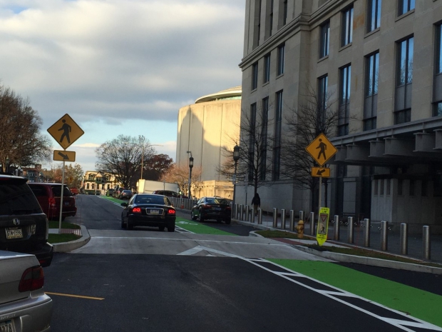
The study said the crossings "prioritise the right of way for pedestrians or cyclists at minor intersections and slip lanes, allowing for greater continuity of movement".

This is not the first idea from the study to be taken on board. Other ideas adopted include narrowing road lanes to slow down traffic.

Kembangan residents say the new feature has deterred speedsters. "Sometimes, cars just turn and speed in. Now, I notice they are more cautious," said civil servant Mary Tan, 50, who brisk-walks on the park connector daily.

Domestic worker Eli Widiyawati, 28, who cycles twice weekly along the park connector to get to the nearby market, agrees. "It's very convenient - we don't have to get off the bike to cross the road now."

But some motorists feel the new crossings might create confusion. "If the idea is to give pedestrians right of way, then they should make it a zebra crossing. Now, it's a bit of a grey area," said cabby Ng Kok Chye, 49.

Still, experts said the new crossings make road junctions safer.

Mr Francis Chu, co-founder of cycling group LoveCyclingSG, said road junctions are potential conflict zones and accidents often happen because users do not have time to react to the unexpected. "In that sense, this gives all users more time to negotiate this conflict zone."

Dr Alexander Erath, a transport researcher at the Singapore-ETH Future Cities Laboratory, believes measures like this provide more direct connections for cyclists and pedestrians, adding that people spend considerable travelling time walking or waiting for public transport.

"There is huge potential to improve conditions," he said. "This is one clear policy measure that brings us in this direction."
 
I was thinking a long-term solution (if the Allen doesnt get torn out before it happens) would be to create a little Beltline Rail Deck esque park between the two bridges.

There were already plans to deck the Allen
View attachment 259527

This would only relegate the proposal to the Beltline area between the two bridges
There can be another deck south of Viewmount to connect Benner Park with Viewmount Park to become one park. As @W. K. Lis showed us, the two parks were originally a single park until the Allen split it in two.
 

Back
Top