News   Apr 18, 2024
 354     1 
News   Apr 18, 2024
 1.4K     3 
News   Apr 18, 2024
 367     0 

Transit Fantasy Maps

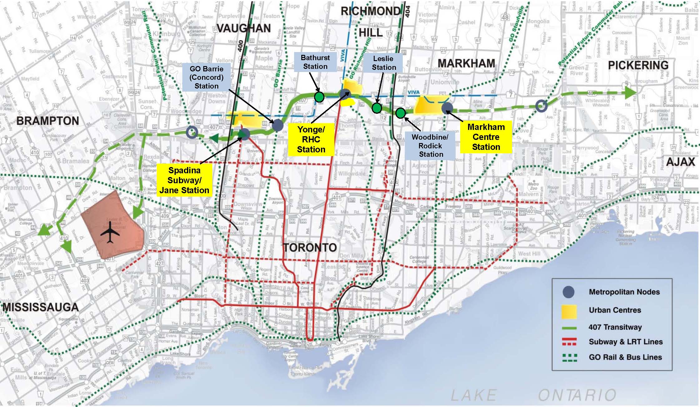
Counter-argument: With the completion of the Crosstown, those along the Eglinton Corridor can access the UPX at Mount Dennis. Why is it important for the Crosstown to go to Pearson as well?

Also, I want to question the logic of prioritizing the employment at Pearson Airport over the employment at ACC as the right decision. Specifically, I question if whether it would be better for economic growth in the region overall if the (more white-collar) jobs located at the firms in ACC were more accessible to labour pool of Toronto. Pearson Airport is already served by the UPX and 192 Kipling Rocket.

That said, this idea should have some thought towards a greater local connectivity strategy with Pearson Airport. I'm not sure what the future of the Link Train is with the Pearson Transit Hub, but maybe it can serve as a shuttle to the Renforth Gateway.
Idea: extend the LINK train to connect all adjacent employment areas, not just ACC; interchange stations at Kitchener Line, Pearson, and Renforth Gateway.
 
I know this is a fantasy thread, but I'd love to see someone create a TTC-style map with all the (likely) coming realities in terms of subways, LRTs and streetcars, such as...
  • Line 1 extension to Richmond Hill
  • Line 2 extension to McCowan
  • Line 3 removal as SRT, but added as Ontario Line from Science Centre to Exhibition
  • Line 5 from Pearson to UTS (although, I imagine Kennedy to UTS might actually be a Line 7)
  • Line 6 from Finch W to Humber North
  • Waterfront East/West streetcars (although this one is harder)
  • Broadview streetcar extension
 
Last edited:
I know this is a fantasy thread, but I'd love to see a TTC-style map with all the (likely) coming realities in terms of subways, LRTs and streetcars, such as...
  • Line 1 extension to Richmond Hill
  • Line 2 extension to McCowan
  • Line 3 removal as SRT, but added as Ontario Line from Science Centre to Exhibition
  • Line 5 from Pearson to UTS (although, I imagine Kennedy to UTS might actually be a Line 7)
  • Line 6 from Finch W to Humber North
  • Waterfront East/West streetcars (although this one is harder)
  • Broadview streetcar extension
Do you mean TTC Subway and Streetcar Map, classic map above the doors, or System Map? The map above the doors are likely going away (or be simplified to strips).
 
I mean a system map (the new style) with all the (likely) coming additions.

With many GO train lines becoming All Day very soon, or at least after RER, it would be nice to see them on the map too, within the Toronto borders. Maybe very subtly, like sort of in behind the TTC map, with the stations being shown (and something like "separate fare required" beside them)
 
Do you mean TTC Subway and Streetcar Map, classic map above the doors, or System Map? The map above the doors are likely going away (or be simplified to strips).

Heres a high res version of that map btw

211252
 
^I was wondering that too. Toronto clearly needs another higher order east-west link. How realistic is it to use that corridor for passenger rail? @crs1026 @smallspy
 
With many GO train lines becoming All Day very soon, or at least after RER, it would be nice to see them on the map too, within the Toronto borders. Maybe very subtly, like sort of in behind the TTC map, with the stations being shown (and something like "separate fare required" beside them)
Which is what Montreal does on their maps with Exo.

Heres a high res version of that map btw
Now someone with more graphic skills than me... get at 'er!
 
^I was wondering that too. Toronto clearly needs another higher order east-west link. How realistic is it to use that corridor for passenger rail? @crs1026 @smallspy

Not possible, thats CN's York sub and it was built specifically for freight to bypass our passenger network. Its off limits.

The East-West link up north will be the 407 Transitway.

stations.jpg

211275


Do not be mistaken with the 407 name, this will not be buses on the highway. Originally it will be a completely grade separated busway like the Missisauga Transitway, but can be upgraded to LRT, like the Ottawa Confederation Line.
 
Thanks Rob. As for the 407 transit way, repeat after me: light metro! (Cue the metro semantics debate)
 
How useful would a north of Steeles GO route be to go from Durham, to York Region, and then to Brampton bypassing Toronto altogether.


ci-missinglink26jpg.jpg

I definitely think it would. I call it the North Toronto Crosstown. I'd even go so far as to add a link to the Kitchener tracks so that the service could serve the Pearson Airport Transit Hub
 
Thanks Rob. As for the 407 transit way, repeat after me: light metro! (Cue the metro semantics debate)

Absolutely. And there are LRT trains out there that can travel up to 130km/h, which, coupled with a complete grade separation, would be similar to GO-RER speed/service. Specifically the tram-trains can go fast.

Like the Citadis Dualis

211306


Back
Top