


JohnnyRenton
New Member
I thought this might be something that people here would enjoy seeing. As part of a project I am doing mapping changes in several Canadian cities over the past few decades, I decided to take a look at investment in GO Train infrastructure in the GTA. The reason for this was simple. The GO Train network is 5 or 10 years away from being radically changed from a commuter service, into a regional rail service. But just 15 years ago, much of the network was dilapidated, antiquated, and thoroughly un-modern. Having watched the developments over the years I knew a lot had been done to start modernizing the network, and with curiosity getting the best of me, I decided to catalogue and map it out in detail, along with attaching the actual costs (where available), to all these investments.
Before jumping in, a few notes. First, the time frame I selected, from 2006 - Sept 2019, was chosen because 2006 was the start of the GO TRIPS program, the first major investment to the GO network in the contemporary era. The end date was whenever the map was actually completed. Only projects that have been completed, or started, are on the map. So even though some, like the Davenport Diamond, Lakeshore upgrades, new RER stations, etc, will be starting any day in some cases, I did not include them as there were no shovels in the ground as of when the map was completed. This of course does mean that the map would have a lot more on it if done in a years time.
As best as possible, I tried to find out the actual costs of each of the projects, big or small. As anyone who has tried to navigate through old online government archives will know, pages change or end up down the memory hole, so not every project was able to have a cost attached to it. All costs are what was quoted in the year the projects were done. Nothing has been adjusted to reflect inflation. It is also worth noting that there are probably a hundred or more smaller projects (parking lots, platform extensions, accessibility upgrades, etc), that are not included on this map. This is in part because there wouldn’t have been space on the map, and because getting exact details about them would have involved an incredible amount of time to research properly.
I have made all efforts to make sure the map is as accurate, and comprehensive as possible, but certainly don’t claim that it is perfect (though it is close enough that I am confident throwing it onto the internet). And for those that might be interested, this map was created in QGIS, so yes, you can make great maps in native Mac apps. I opted to do the map this way, instead of a custom, online Google Map, because classic cartography is fun, and though this map isn’t great for mobile, it does look great on a large desktop.
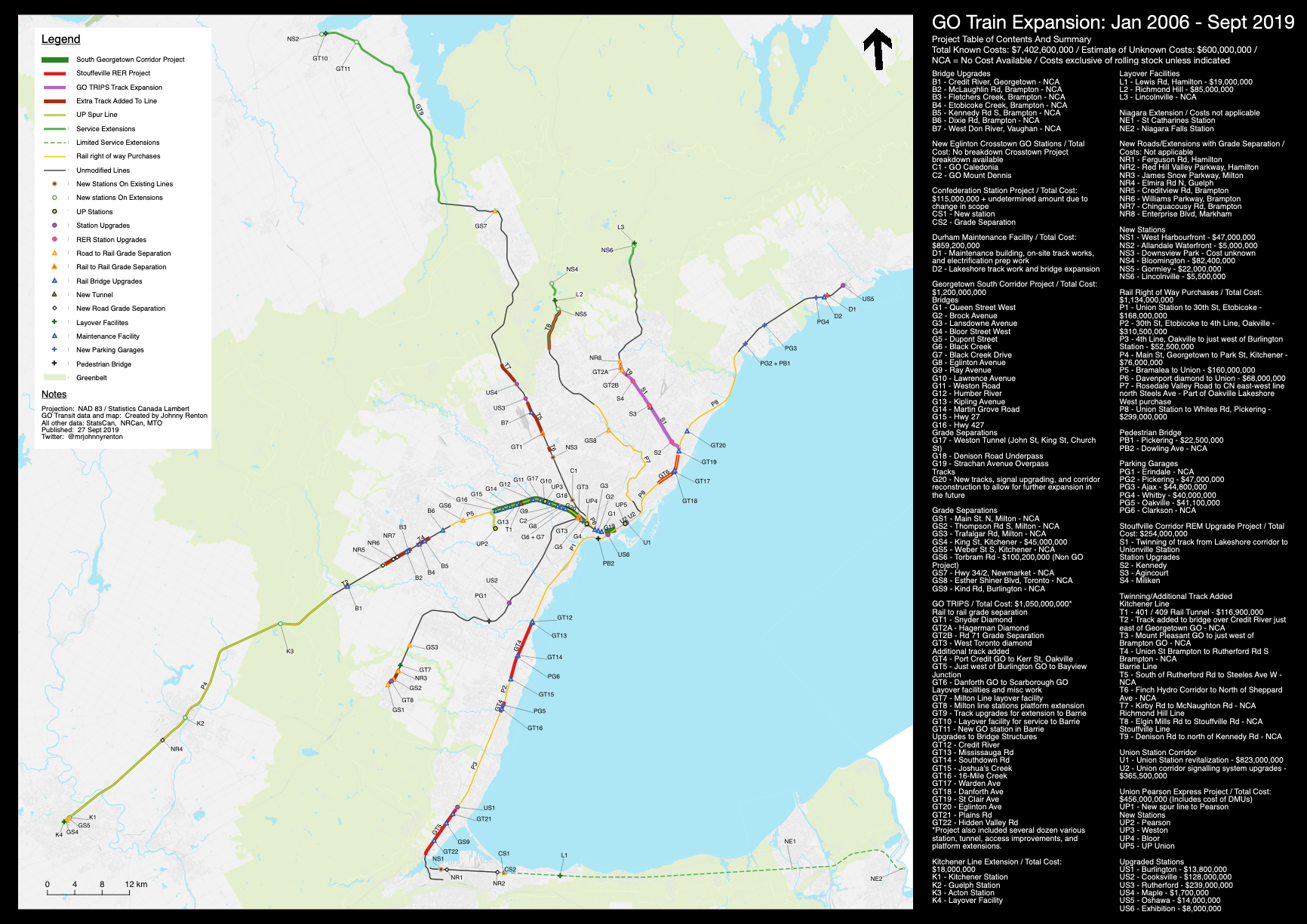
So lets look at the map. The image that appears below is a scaled down version of the map.
Click on this link, for a larger resolution version.
Lets quickly run through some numbers:
Total known cost of mapped investments: $7.4 billion
Total estimated cost of remaining mapped investments: $600 million
Total estimated cost of unmapped projects: $500 - $750million
Total number of bridge upgrades: 35
Total number of new stations on existing lines: 6
Total number of new stations on extensions: 10
Total number of existing roads that were grade separated: 15
Total number of rail to rail grade separations: 3
Total number of new roads built with grade separations: 7
Total number of station rebuilds or major upgrades: 11
There are also some interesting trends that emerged when you look at all the investments mapped out. First, almost all of the money spent was inside the greenbelt. While extensions did push service beyond the greenbelt, the amount actually spent on those sections was minuscule compared to the overall amount spent. This will of course change in the future.
Also interesting is how much of the investment was actually inside the boundaries of the City of Toronto. Without full project breakdowns only an estimate can be given, but there is likely around $4 billion that was spent just within Toronto. Now, that makes sense as lines are going to be busier as they get closer to the centre, and thus need more money to modernize them properly for that higher capacity. But that investment could, and to a certain extent is, being leveraged so that Toronto residents also get better transit service as a result (I know that is a comment that will likely elicit some reactions here, given the ongoing saga of Smart Track/RER. For the purpose of this post, whether or not enough is being done within Toronto is not something I will talk about).
What is perhaps most interesting about this map, in my opinion, and what it shows is that with the exception of the Georgetown South/UP project, which was around $1.75 billion in total between the two of them, there are actually few projects that would be considered mega-projects. Yes, some, like the Union Station upgrade, and the Durham Maintenance facility, were not cheap, but most of what GO has done over the past 13.5 years has been a collection of smaller projects that have focused on the “unsexy” but critical parts of modernizing the network, such as bridge upgrades, grade separations, signalling systems, station upgrades and better integration with local transit networks, etc.
This patchwork, under the radar approach to developing the network, often at times when the political and social climate towards public transit meant funding was thin, has really allowed GO/Metrolinx to form a strong, modern backbone for what will be the most exciting part of their expansion plans. (That backbone isn't fully constructed yet, but it is getting close).
In 5 - 10 years time, when GO/RER becomes the transit darling of North America, many people will probably look at only the most recent investments that put them there. But in fact, it is the time from 2006 to today that cities/regions looking to build a regional rail network should be looking at. That is the time when all the hardest, most under appreciated work went into creating just the right conditions for an epic transformation. For people in Toronto or the GTA the map is likely just going to be a look back into the past. For other cities and regions, it can offer a lot of insight on how a pragmatic, under the radar approach to developing a regional rail network could be the right approach to getting the early days of their projects started. It might be less desirable than a mega-project that does it all at once, but for cities even more car-dependent than Toronto and the GTA, this might be the only strategy that could work for them.
I could say a lot more about this map but I will leave it at that. I know that a lot of people are cynical about public transit investments in Toronto, and all across Canada for that matter. And yes, it can often seem as though things are not going fast enough. I also think it is important to remember that radically changing cities and regions from almost exclusively car-oriented to also being places with great public transit, along with an ability to walk and bike, is not a small task, especially when Canadian cities exploded during the suburban age. Trying to battle against all the money that continues to be behind suburban growth is a massive undertaking, and yet Toronto and the GTA have managed to take what was a hugely under-utilized set of corridors, and begin to transform them. GO/Metrolinx often get a lot of heat from the public, sometimes deserved, but I don't think it gets enough credit for pushing through what has often been a challenging political and social environment to get the GO Train network to where it is today.
Before jumping in, a few notes. First, the time frame I selected, from 2006 - Sept 2019, was chosen because 2006 was the start of the GO TRIPS program, the first major investment to the GO network in the contemporary era. The end date was whenever the map was actually completed. Only projects that have been completed, or started, are on the map. So even though some, like the Davenport Diamond, Lakeshore upgrades, new RER stations, etc, will be starting any day in some cases, I did not include them as there were no shovels in the ground as of when the map was completed. This of course does mean that the map would have a lot more on it if done in a years time.
As best as possible, I tried to find out the actual costs of each of the projects, big or small. As anyone who has tried to navigate through old online government archives will know, pages change or end up down the memory hole, so not every project was able to have a cost attached to it. All costs are what was quoted in the year the projects were done. Nothing has been adjusted to reflect inflation. It is also worth noting that there are probably a hundred or more smaller projects (parking lots, platform extensions, accessibility upgrades, etc), that are not included on this map. This is in part because there wouldn’t have been space on the map, and because getting exact details about them would have involved an incredible amount of time to research properly.
I have made all efforts to make sure the map is as accurate, and comprehensive as possible, but certainly don’t claim that it is perfect (though it is close enough that I am confident throwing it onto the internet). And for those that might be interested, this map was created in QGIS, so yes, you can make great maps in native Mac apps. I opted to do the map this way, instead of a custom, online Google Map, because classic cartography is fun, and though this map isn’t great for mobile, it does look great on a large desktop.
So lets look at the map. The image that appears below is a scaled down version of the map.
Click on this link, for a larger resolution version.
Lets quickly run through some numbers:
Total known cost of mapped investments: $7.4 billion
Total estimated cost of remaining mapped investments: $600 million
Total estimated cost of unmapped projects: $500 - $750million
Total number of bridge upgrades: 35
Total number of new stations on existing lines: 6
Total number of new stations on extensions: 10
Total number of existing roads that were grade separated: 15
Total number of rail to rail grade separations: 3
Total number of new roads built with grade separations: 7
Total number of station rebuilds or major upgrades: 11
There are also some interesting trends that emerged when you look at all the investments mapped out. First, almost all of the money spent was inside the greenbelt. While extensions did push service beyond the greenbelt, the amount actually spent on those sections was minuscule compared to the overall amount spent. This will of course change in the future.
Also interesting is how much of the investment was actually inside the boundaries of the City of Toronto. Without full project breakdowns only an estimate can be given, but there is likely around $4 billion that was spent just within Toronto. Now, that makes sense as lines are going to be busier as they get closer to the centre, and thus need more money to modernize them properly for that higher capacity. But that investment could, and to a certain extent is, being leveraged so that Toronto residents also get better transit service as a result (I know that is a comment that will likely elicit some reactions here, given the ongoing saga of Smart Track/RER. For the purpose of this post, whether or not enough is being done within Toronto is not something I will talk about).
What is perhaps most interesting about this map, in my opinion, and what it shows is that with the exception of the Georgetown South/UP project, which was around $1.75 billion in total between the two of them, there are actually few projects that would be considered mega-projects. Yes, some, like the Union Station upgrade, and the Durham Maintenance facility, were not cheap, but most of what GO has done over the past 13.5 years has been a collection of smaller projects that have focused on the “unsexy” but critical parts of modernizing the network, such as bridge upgrades, grade separations, signalling systems, station upgrades and better integration with local transit networks, etc.
This patchwork, under the radar approach to developing the network, often at times when the political and social climate towards public transit meant funding was thin, has really allowed GO/Metrolinx to form a strong, modern backbone for what will be the most exciting part of their expansion plans. (That backbone isn't fully constructed yet, but it is getting close).
In 5 - 10 years time, when GO/RER becomes the transit darling of North America, many people will probably look at only the most recent investments that put them there. But in fact, it is the time from 2006 to today that cities/regions looking to build a regional rail network should be looking at. That is the time when all the hardest, most under appreciated work went into creating just the right conditions for an epic transformation. For people in Toronto or the GTA the map is likely just going to be a look back into the past. For other cities and regions, it can offer a lot of insight on how a pragmatic, under the radar approach to developing a regional rail network could be the right approach to getting the early days of their projects started. It might be less desirable than a mega-project that does it all at once, but for cities even more car-dependent than Toronto and the GTA, this might be the only strategy that could work for them.
I could say a lot more about this map but I will leave it at that. I know that a lot of people are cynical about public transit investments in Toronto, and all across Canada for that matter. And yes, it can often seem as though things are not going fast enough. I also think it is important to remember that radically changing cities and regions from almost exclusively car-oriented to also being places with great public transit, along with an ability to walk and bike, is not a small task, especially when Canadian cities exploded during the suburban age. Trying to battle against all the money that continues to be behind suburban growth is a massive undertaking, and yet Toronto and the GTA have managed to take what was a hugely under-utilized set of corridors, and begin to transform them. GO/Metrolinx often get a lot of heat from the public, sometimes deserved, but I don't think it gets enough credit for pushing through what has often been a challenging political and social environment to get the GO Train network to where it is today.