salsa
Senior Member
That vote annoyingly failed, but Hamilton Chamber is still working on getting it added later. Possibly a future Bay infill.
Hopefully. But who is gonna pay for it later?
That vote annoyingly failed, but Hamilton Chamber is still working on getting it added later. Possibly a future Bay infill.
That vote annoyingly failed, but Hamilton Chamber is still working on getting it added later. Possibly a future Bay infill.
Not for LRVs, but for drivers to more easily access the maintenance facility. It can also act as an alternate route or detour from west-of-403 to east-of-403, bypassing the Main/King bridge (taking thr Longwood bridge instead to get into City of Hamilton). Which is useful during construction, too.
And Frid St is a potential business improvement area, for business densification (e.g. Office towers invading a business park, once Dundurn LRT station built).
Possibly developers. Reportedly, it is only 2.5 million dollars to add that station (if added back quick).Hopefully. But who is gonna pay for it later?
What is the purpose of the Frid Street Extension? Is it some kind of turn back for the LRVs?
Here you go. from LRT Presentation of Open House second series.Are you able to post the track plan for that stretch? I'd be interested in seeing it.
Here you go. from LRT Presentation of Open House second series.
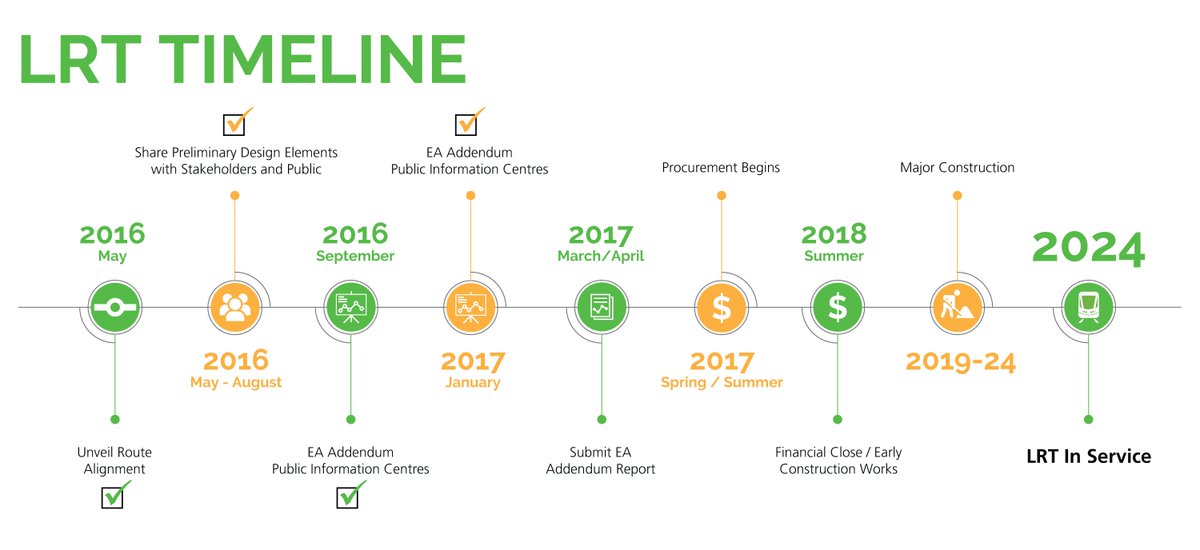
Prep stuff 2018So when are the first shovels going to be in the ground?
Any chance this gets slipped back in as part of the Eastgate extension process?You can thank Hamilton council for this mindless decision.
Councillors kill idea of adding a Bay Street LRT stop
http://www.cbc.ca/news/canada/hamil...dea-of-adding-a-bay-street-lrt-stop-1.3984348
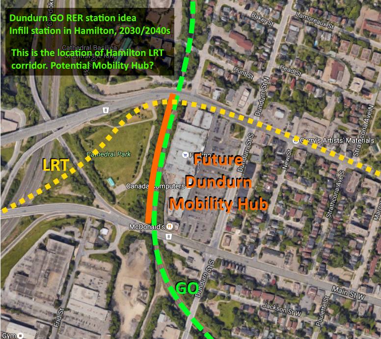
On the topic of Frid St, I've tweeted in the past that Dundurn could be a potential Mobility Hub.
Existing GO trains already coast behind Dundurn Mall, under the planned LRT bridge. What if a connection could be made? Dundurn Mobility Hub!
A 12 car trainset is 12 x 26m (312m) so the platform would have to bend a bit to be that long. Given the map is only a 2D view and I haven't been on a Hunter St GO service, is there any difficulty with stopping trains in either direction because of a nearby grade (probably more to the north than the south, surely the junction track is reasonably flat)A GO platform would just be simply built behind Dundurn Mall (a redeveloped version of) capable of opening to 8 coach EMU trains (or diesel 12 coach platform if abutting underneath King bridge)
A few curved GO platforms exists, this curves less. Even Union Platform 27 seems to curve more. So it should be OK.A 12 car trainset is 12 x 26m (312m) so the platform would have to bend a bit to be that long. Given the map is only a 2D view and I haven't been on a Hunter St GO service, is there any difficulty with stopping trains in either direction because of a nearby grade (probably more to the north than the south, surely the junction track is reasonably flat)
If you want to see a curve platform that can't see any end at all, go to Newmarket and see it first hand. You will find similar platforms in Europe, as will USA.A few curved GO platforms exists, this curves less. Even Union Platform 27 seems to curve more. So it should be OK.
From my recollection, the grade here seemed flat, but I will need to pay attention on my next trip.


