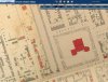
News   May 17, 2024
 224     0 
News   May 17, 2024
 510     0 
News   May 16, 2024
 865     1 

Miscellany Toronto Photographs: Then and Now

I believe the ghost of Gibson's Lane is still discernable through the property line at the N end of the Canadian Tire/Fellowship Towers rear parking (visible from the subway)
you're right

in the map i posted, there are two triangular lots adjacent to gibson lane as it meets yonge -- the one on the north is divided into 5 pieces, and the street number for the building on piece 3 is 885 yonge

the current building at 885 yonge is adjacent to this driveway --

https://www.google.ca/maps/@43.6742...ata=!3m4!1e1!3m2!1slfMBih9ij0Hh7yEyW0u7Xg!2e0

so gibson lane cuts diagonally through the tower
 
Looking south to University Avenue from Queen's Park:

1900:

universityavenuesouth1900.jpg


1908:

universityavenuesouth1908.jpg


August 1, 1914:

universityavenueaugust11914.jpg


1947 (pre-widening):


1950's:

POSTCARD - TORONTO - QUEEN'S PARK - LOOKING S ON UNIVERSITY - 1950s.jpg


1960's:


Today (thanks to Jack Landau "MidTowner"):

universityavenuefromQP.jpg
 

Attachments

  • universityavenueaugust11914.jpg
    universityavenueaugust11914.jpg
    99.2 KB · Views: 906
  • universityavenuefromQP.jpg
    universityavenuefromQP.jpg
    83.8 KB · Views: 893
  • POSTCARD - TORONTO - QUEEN'S PARK - LOOKING S ON UNIVERSITY - 1950s.jpg
    POSTCARD - TORONTO - QUEEN'S PARK - LOOKING S ON UNIVERSITY - 1950s.jpg
    97.7 KB · Views: 936
  • universityavenuesouth1900.jpg
    universityavenuesouth1900.jpg
    99.2 KB · Views: 883
  • universityavenuesouth1908.jpg
    universityavenuesouth1908.jpg
    96.2 KB · Views: 881
Last edited:
Well-done series, thecharioteer!

Here's another version (2011):

UniversityfromQPwebsize_zps88a9ee89.jpg
 
Last edited by a moderator:
Thanks, Goldie! Here are two I just found from the TPL site (pre-statue of John A).

The view in 1885:

universityavenue1885.jpg


The view in 1890:

universityavenue1890.jpg
 

Attachments

  • universityavenue1890.jpg
    universityavenue1890.jpg
    96.6 KB · Views: 916
  • universityavenue1885.jpg
    universityavenue1885.jpg
    96.1 KB · Views: 915
Last edited:
Excellent look into our early history - with some powerful armamenta too.
This was one year before construction began on the present Legislative Buildings.

Here's a view of the same road up north where it meets Bloor:

TNAvenueRdatBloor1932_zps25602caf.jpg
 
Last edited by a moderator:
It bothers me a little bit too much that the Queen's Park walkway/Sir John A. statue don't line up with the center median of University Avenue...
really? i had never noticed

but that's likely because today's university avenue used to be two parallel roads on separate city lots

i forget where i read the details... some book on toronto history...

see the "simcoe's gentry" web site on park lot 12

edited: i believe the original university avenue (and the aligned queen's park walk) was on the eastern side of lot 12, and was called "college avenue", while a separate road called "park lane" was on the western side of lot 11

you can see them, side by side, beside osgoode hall in this 1858 map --

college-road-park-lane.jpg


note the gates at queen -- college avenue was a private road
 

Attachments

  • college-road-park-lane.jpg
    college-road-park-lane.jpg
    98.6 KB · Views: 1,026
Last edited:
really? i had never noticed

but that's likely because today's university avenue used to be two parallel roads on separate city lots

i forget where i read the details... some book on toronto history...

see the "simcoe's gentry" web site on park lot 12

edited: i believe the original university avenue (and the aligned queen's park walk) was on the eastern side of lot 12, and was called "college avenue", while a separate road called "park lane" was on the western side of lot 11

you can see them, side by side, beside osgoode hall in this 1858 map --

View attachment 29766

note the gates at queen -- college avenue was a private road

My very first post (#41) on UT, a little more than 5 years ago, outlined the history of "College Avenue", and its parallel road way "University Street":

http://urbantoronto.ca/forum/showthread.php/9540-University-Avenue-Toronto-s-Grand-Avenue/page3

1890 Goad Atlas:


The name "University Avenue" appears for the first time in the 1899 edition of the Goad Atlas.

On the 1924 map, it makes reference to "Park Lane", (a name which appears on the 1858 Boulton map, but none of the Goads) further confusing the issue:


However, the 1874 Hart Rawlinson Compilation map shows a dotted line running up the centre of "College Avenue", which undoubtedly determined the centre-line of the future Provincial Legislature Buildings and the statue of John A., illustrating again why the centre medians of today's University Avenue are "off-centre" with both the statue and the provincial parliament buildings.


http://oldtorontomaps.blogspot.ca/2013/01/1874-hart-rawlinson-city-of-toronto.html
 
Last edited:
Excellent look into our early history - with some powerful armamenta too.
This was one year before construction began on the present Legislative Buildings.

Here's a view of the same road up north where it meets Bloor:

TNAvenueRdatBloor1932_zps25602caf.jpg
That guy sitting on the Cannon frozen in time , i often wonder about the lives of the people in these old b/w photos , did they enjoy their life , did they suffer trials and tribulations what were their thoughts , did the guy on the cannon wonder what his toronto will be like in 100 years time, as someone viewing these colour photos in 100 years will wonder what became of the subjects also.

Photography our own personal time machine.
 
That guy sitting on the Cannon frozen in time , i often wonder about the lives of the people in these old b/w photos , did they enjoy their life , did they suffer trials and tribulations what were their thoughts , did the guy on the cannon wonder what his toronto will be like in 100 years time, as someone viewing these colour photos in 100 years will wonder what became of the subjects also. Photography our own personal time machine.

Yes, I thought exactly the same thing - though not so poetically. The cannon guy is also quite ''sultry" :->
 
you're right

in the map i posted, there are two triangular lots adjacent to gibson lane as it meets yonge -- the one on the north is divided into 5 pieces, and the street number for the building on piece 3 is 885 yonge

the current building at 885 yonge is adjacent to this driveway --

https://www.google.ca/maps/@43.6742...ata=!3m4!1e1!3m2!1slfMBih9ij0Hh7yEyW0u7Xg!2e0

so gibson lane cuts diagonally through the tower

The current buildings at 885 and 887 and 889 Yonge ARE the past buildings that appear in orange on the map numbered 1-2-3.
Heritage listed - "Part of a row of shops at 885-889 Yonge Street -adopted by City Council on June 20, 1973"
 
My very first post (#41) on UT, a little more than 5 years ago, outlined the history of "College Avenue", and its parallel road way "University Street":

http://urbantoronto.ca/forum/showthread.php/9540-University-Avenue-Toronto-s-Grand-Avenue/page3

However, the 1874 Hart Rawlinson Compilation map shows a dotted line running up the centre of "College Avenue", which undoubtedly determined the centre-line of the future Provincial Legislature Buildings and the statue of John A., illustrating again why the centre medians of today's University Avenue are "off-centre" with both the statue and the provincial parliament buildings.


http://oldtorontomaps.blogspot.ca/2013/01/1874-hart-rawlinson-city-of-toronto.html


Oh that’s rich: There was a lunatic asylum where the Legislative Assembly of Ontario now sits!
 
There are actually some interesting ghost stories about Queen's Park that suggest some of the prior patients still wander the halls, particlarly the downstairs hall by the cafeteria. See torontoghosts.org for other stories about Toronto area "haunts", no pun intended.
 

Back
Top