Over the past few weeks, Metrolinx has released details of its current plans for the Ontario Line – the future rapid transit line stretching from Exhibition Place to Don Mills Road and Eglinton Avenue East. This week, the regional transit agency revealed its early plans for the fourth—and final—section of the line between Danforth and Eglinton avenues. (All maps below other than the skewed Thorncliffe Park station one flout cartographic convention and are oriented with north to the right.)
 The northern segment of the Ontario line stretches between Danforth and Eglinton Avenues, image: Metrolinx
This segment of the line starts immediately south of the TTC's Pape Station. The current proposal relocates the new Ontario Line station on the east side of Pape Avenue, instead of under the street, north of Danforth Avenue. Passengers will be able to easily transfer to and from Line 2 Bloor-Danforth subway trains here. Metrolinx says that "By positioning the Ontario Line station out of the street and straddling Line 2, impacts to area traffic during construction are reduced and [passengers] will have smoother transfers between the lines."
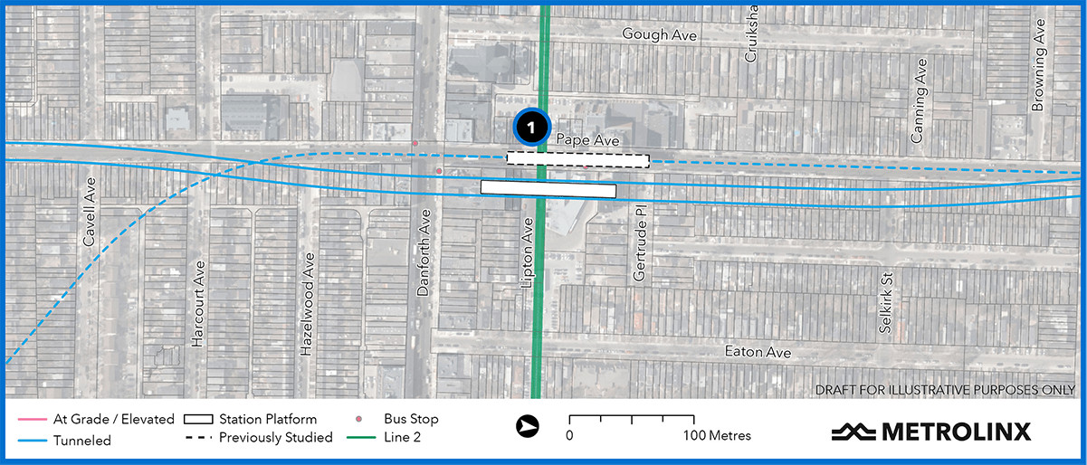 The Ontario Line's Pape Station (#1) would lie under the TTC Line 2 station, image: Metrolinx
The new station fulfills a major goal of the Ontario Line: to intercept westbound riders bound for Bloor-Yonge Station, where many of them would then transfer to Line 1 to travel downtown. Metrolinx estimates that this will reduce crowding on the busiest stretch of Line 2 by 22 per cent and eliminate 19 percent of the passengers in the Bloor-Yonge interchange.
The Ontario Line tunnel then continues northward under Pape Avenue, until it swings to the west side of the street. A future Cosburn Station extends north and south under Cosburn Avenue, west of Pape. By shifting the site of the station to the west, Metrolinx says that it will need to relocate fewer of the underground utilities, including the water main the City of Toronto recently upgraded. A post on the Metrolinx news blog further highlights the design of this site by adding, "Building the station away from the street means that the tracks can be shallower – reducing the time people need to get in and out of the station."
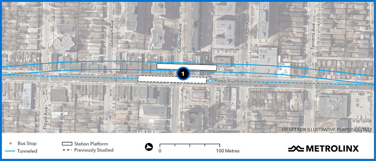 The future Cosburn Station (#1) straddles Cosburn Avenue west of Pape Avenue, image: Metrolinx
Outstanding from these plans are details like where Metrolinx might build station entrances/exits, what the construction impact will be on neighbourhoods, and how many buildings will be need to be purchased for demolition. In regards to Cosburn, the transit agency explains that the property requirements for locating the station west of Pape are comparable to what it would have needed if it built the station directly under the street, while imposing fewer construction impacts on area traffic, which is "an added benefit". Although it is still finalizing property requirements, Metrolinx claims it will only acquire property necessary for the project and strive to minimize the impacts of construction." (But, we wonder, what's the future of the row of stores on the west side of Pape at Cosburn that are key to the success of the Pape Village business area?)
The line continues northward under Pape Avenue and its northern extension, quiet Minton Place, a residential street. In the rear of three properties on Minton, the rapid-transit line would emerge out of the tunnel, through a portal and onto a bridge that would carry the trains across the wide Don River Valley. Again, one of the missing details is the impact on Minton Place, both during and after construction of this infrastructure.
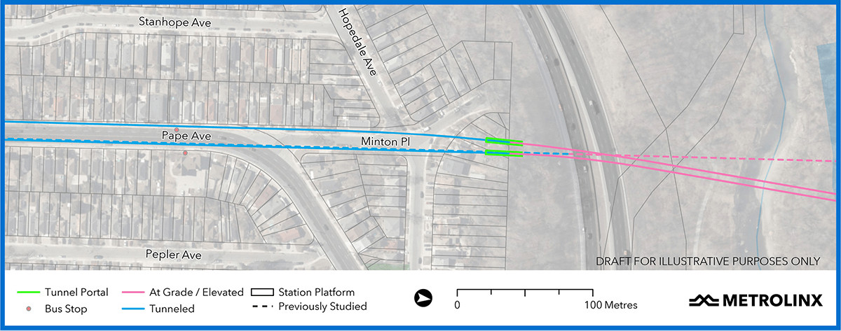 Ontario-line rains would emerge from the tunnel at Minton Place onto a bridge over the Don River, image: Metrolinx
Regarding the bridge over the Don, Metrolinx is only unveiling tidbits of information at this point, simply saying that, "Using modern bridge construction techniques, the visual and environmental impacts of the structure will be minimalized [sic]." Nevertheless, this will likely be a major infrastructure project in itself.
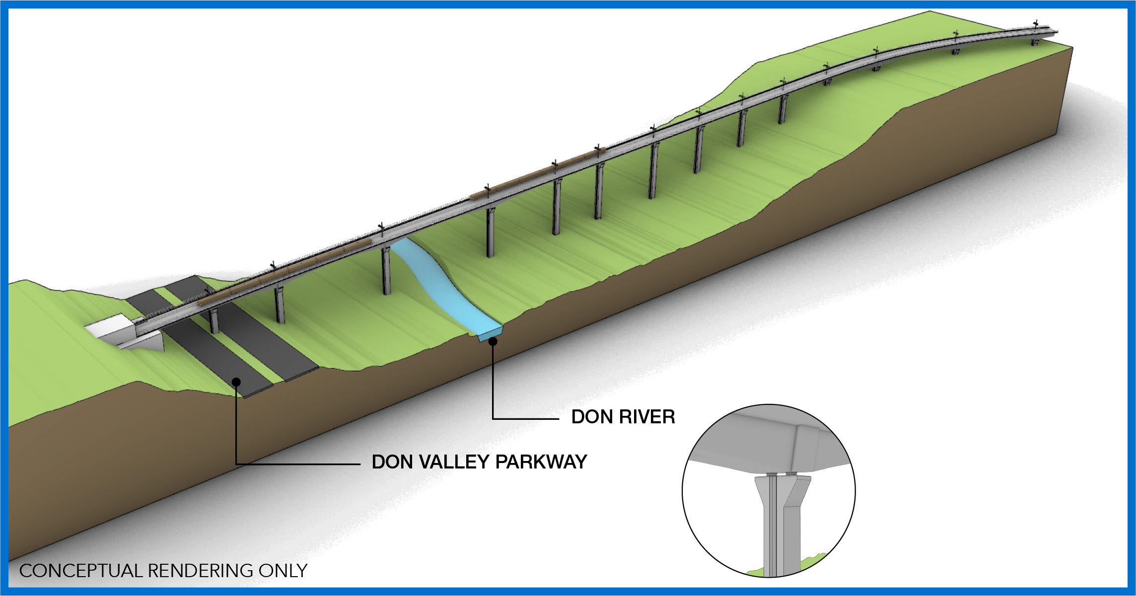 First of two renderings of the future Ontario-Line bridge over the Don Vally, image: Metrolinx
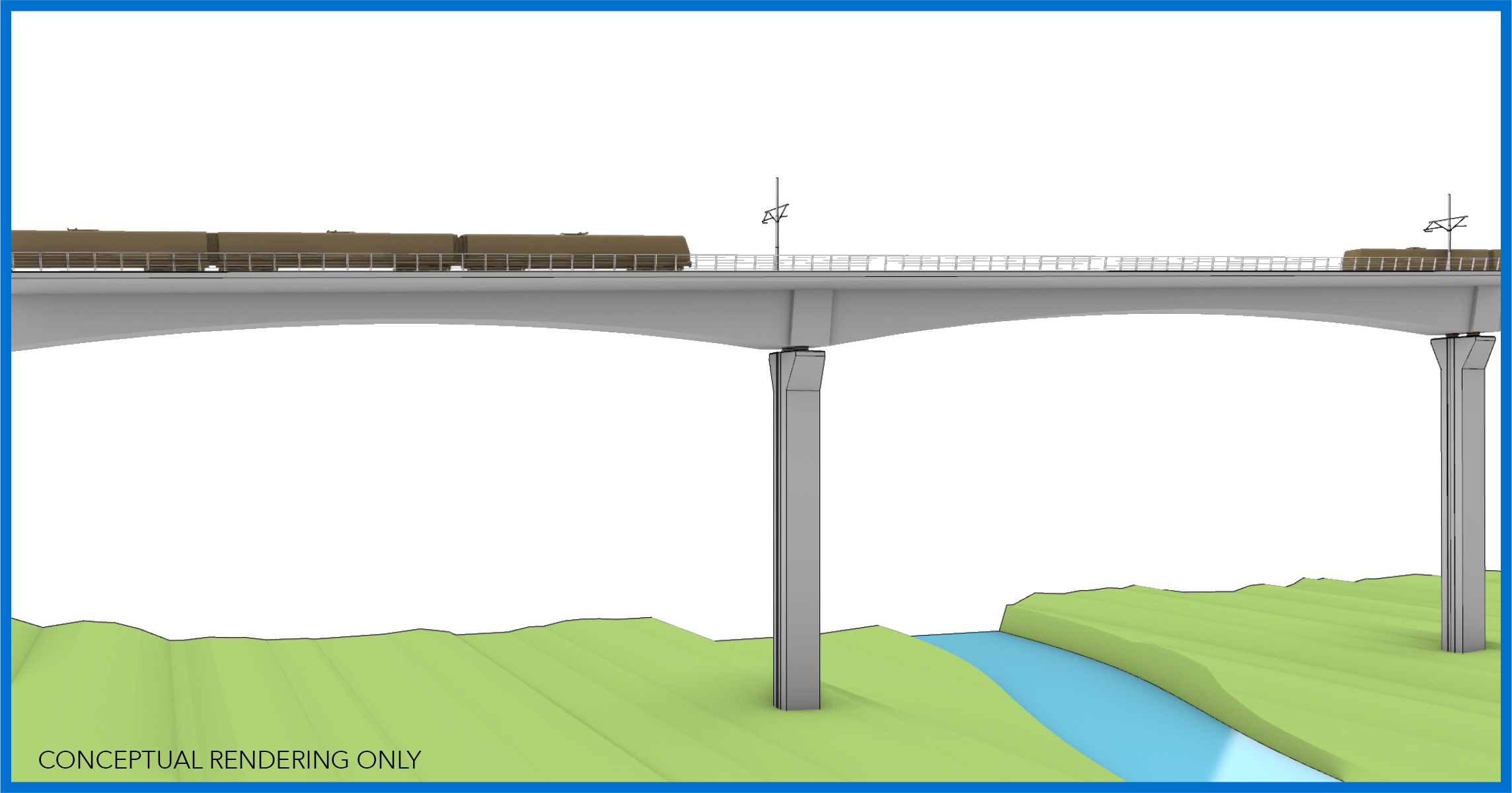 Second of two renderings of the future Ontario-Line bridge over the Don Vally, image: Metrolinx
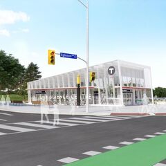
After fording the Don, Ontario Line trains will continue along an elevated structure, crossing Millwood Road and Overlea Boulevard, and continuing along the north side of Overlea to enter Thorncliffe Park Station. This above-ground stop will stand at the western intersection of Overlea with Thorncliffe Park Drive, and, according to Metrolinx, it will "work to make sure this, and other above-ground stations, fit their surroundings with attractive designs." The elevated station is possible because of the wider street layout, and, according to Metrolinx "avoids the need for disruptive tunnelling activities".
The Metrolinx blog post quotes John Potter from the transit agency's Design Division, who emphasized, "We are sensitive to the communities we are serving and we’re working on making the elevated guideways, slender and [with] as few visual distractions as possible."
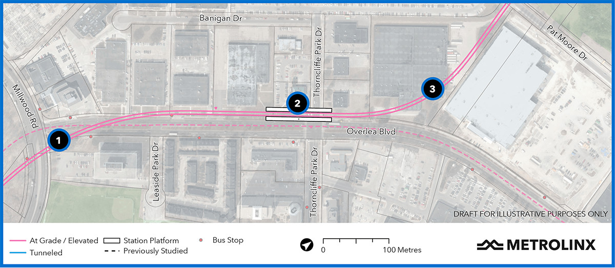 After crossing the valley, the Ontario Line crosses Millwood Road (#1) and runs along Overlea Boulevard on an elevated guideway. Instead of the original plan to proceed along Overlea Boulevard after the station, the Ontario Line will turn to the north (#3), Image: Metrolinx
In a sharp change from its original plans, Metrolinx now intends to divert the line off Overlea Boulevard beyond Thorncliffe Park Station. Originally, it intended to continue the line on guideways above Overlea, through the Thorncliffe Park neighbourhood. At Don Mills Road, the line turned northwards, again above-ground to continue through Flemingdon Park to Eglinton.
Instead, Metrolinx now proposes to divert the live off Overlea to reduce the impact to the communities, including several places of worship. The new plan is to continue the line along a hydro corridor north of and parallel to Overlea, away from residential areas.
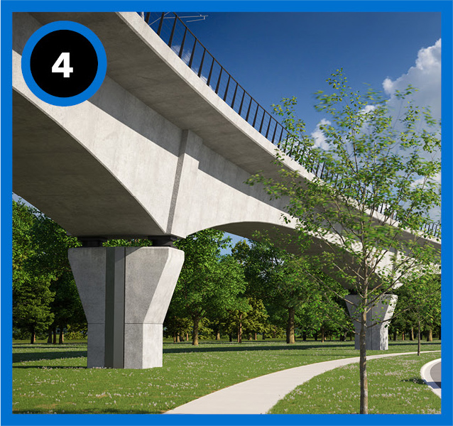 Metrolinx proposes 'slender' guideways like this to reduce the impact to communities, image: Metrolinx
"Making this adjustment is part of our ongoing work to factor in residents’ feedback wherever we can and make sure the new transit line is built in a way that not only serves local transit riders but also fits into the communities they call home," said Malcolm MacKay, Metrolinx Program Sponsor for the Ontario Line in the blog post.
Metrolinx is also exploring sites in the area to determine where it could situate a maintenance and storage facility for the line, which needs to accommodate 200 trains at opening and as many as 250 trains to support future growth. It says, "As teams finalize plans for where this important facility will be located, they will engage with property owners from different areas to help select a site that minimizes community impacts while fulfilling the technical requirements for much-needed Ontario Line service."
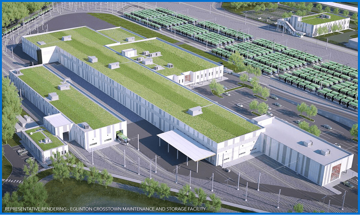 Metrolinx intends to build a maintenance and storage facility near the Thorncliffe Park area, similar to the Eglinton Maintenance and Storage Facility of the Eglinton Crosstown LRT, shown, image: Metrolinx
The new route for the line continues on an elevated guideway over the west branch of the Don River and Ernest Thompson Seton Park to emerge onto Don Mills Road between its northern intersection with Gateway Boulevard and St Dennis Drive – just south of the Ontario Science Centre. It will build the future Flemingdon Park Station on part of a parking lot on the west side of Don Mills. By choosing this location, Metrolinx again hopes to reduce the impact of construction on the nearby community and on traffic.
Metrolinx points out that the Thorncliffe Park and Flemingdon Park stations bring subway service to an area where there is already a huge demand for transit. On weekdays, 28,900 TTC riders board buses along the 25 Don Mills route – the seventh-most used regular bus route in the city – and another 15,800 board buses along the 100 Flemingdon Park route.
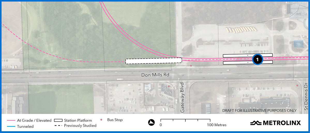 Metrolinx proposes building the new Flemingdon Park Station (#1) on the west side of Don Mills Roads, south of the Ontario Science Centre, image: Metrolinx
The line proceeds northward above Don Mills to its final stop at the future Science Centre Station on the Eglinton Crosstown light rail transit line, now under construction. Metrolinx has altered its plans here, too, building the new Ontario Line station above the Crosstown station on the northeast corner of the Don Mills / Eglinton intersection, instead of the southwest.
This may end up being a complex transfer point for passengers, since the Crosstown station is underground and the Ontario Line stop is above-ground. One of the ironies of having Toronto transit planning constantly in flux is the fact that Science Centre Crosstown Station was built underground so passengers could easily connect with the future Relief-Line subway. Now that the Ontario Government has scrapped the underground Relief Line concept and replaced it with an elevated Ontario Line station here, the opportunity for easier transfers seems lost.
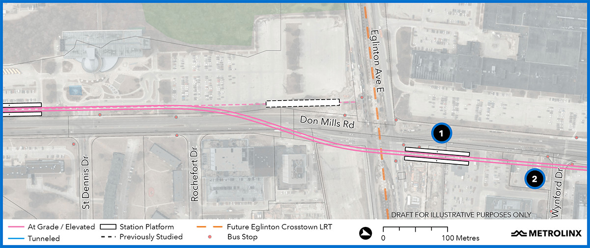 The Ontario Line station at Eglinton and Don Mills (#1) will be above the Science Centre Station on the Eglinton Crosstown LRT. Tail tracks (#2) extend further northward, image: Metrolinx
The transit agency predicts that the nearly 16-kilometre line will reduce the number of passengers boarding Line 1 trains at Eglinton Station by 17 per cent, compared to only three per cent for the earlier, shorter Relief Line South proposal. It also expects the new line will result in less travel time for commuters – from about 42 to 26 minutes for trips between Thorncliffe Park and the financial district at King Street West and Bay Street.
The plan also calls for trail tracks extending further north from the station. Metrolinx can use the tail tracks to store trains overnight. They also protect the site for a future northward extension of the line.
Metrolinx promises to release more details on the Ontario Line over time that, hopefully, will answer many of these questions. It won't start the procurement process to identify contractors to build this section of the line until 2022, although it may start some early works before then.
Metrolinx has already released plans for other sections of the project:
-
West - between Exhibition Place and Queen Street West / Spadina Avenue;
-
Downtown – between Queen West / University Avenue and the Don River; and
-
East – between the Don River and Danforth Avenue.
You can review and comment on the plans for the Ontario Line at the Metrolinx Engage website. You can also add your thoughts about the project in the space provided on this page or in our dedicated Forum thread.
* * *
UrbanToronto has a new way you can track projects through the planning process on a daily basis. Sign up for a free trial of our New Development Insider here.
| Related Companies: | Arcadis |

 24K
24K 


