


Undead
Senior Member
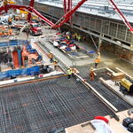
Any details available about the smart signals? I assume these can respond to changing demand in real time? Would be nice to have these installed for all major road reconstructions going forward.
|
|
|
Aren't the smart signals supposed to improve level of service for cars? So why would TT neuter them?I have a feeling that these so called smart signals will last maybe a year before Toronto Transportation neuters them.

 www.blogto.com
5 years from approval to starting construction is nuts.
Five years to design this thing and then another year before construction starts is absolutely baffling. WTF.
This city is a joke when it comes to building anything infrastructure related. To think we've gone from being a one-time envy of the world to now laughing stalk in a couple decades its pretty amazing.
Yet another potential project we can add to John Tory's never ending list of "approved but unfunded projects".
It's the regional road number for York Region. York Regional Road 1.Not sure where else to ask this. Does anyone know why Google Maps identifies Yonge as Highway 1?
Does anyone Know if there is any plan to extend Doris Ave north through the Finch parking lot and connect with the new road for M2M that will be go up to Wedgewood Dr? I'm worried that all the Traffic will be pushed to the extended Beecroft Ave instead of balancing the two out.
This is what I see. That will do least amount of damage to the Neighbourhood. If you don't want a stop sign or stop light, then you can put a round about in. View attachment 305122