News   Jul 26, 2024
 874     0 
News   Jul 26, 2024
 2.3K     2 
News   Jul 26, 2024
 2K     3 

Why has there been no serious deamalgamation campaign?

Deamalgamation is what killed Montreal... why trying to recreate that scenario here?

They're wondering if they should not go back to "one Island, one city" and just ignore the anglophones who would oppose it
 
I think you're being too much the cynical post-Y2K poli-sci student here, viewing everything through the prism of present "obvious" logic, much like those of a socio-cultural bent would view past attitudes t/w women's roles or homosexuality. Because this so-called "misleading" was actually quite universal to the point where, like the misspelling of "Carlton", it became its own truth. Whatever the underlying political structure, as geographic divisions, Ontario's counties and cities were universally presented as one. Maybe it's naivety; maybe it's craft; and maybe there was some clause I'm not presently in a position to seek that "sealed the deal". But: geography transcended politics--and this is something that merits socio-politi-cultural dissection: of why the universal "official" public face of the Ontario county--as borne out through the aforementioned censuses/maps/municipal directories, etc--included cities, even if subtleties of administrative organization (like, the irrelevance of the York County Warden to anything Toronto-related) suggested otherwise.

And to add to the confusion re: administrative vs. geographical definition of "county," remember that there remains a distinction between "separated cities" and "single-tier municipalities" even if, administratively speaking, the two categories are identitcal. Whereas, to me at least, the "separated city" designation suggests a city's administrative separation from the wider geographic unit to which it belongs, the "single-tier municipality" stands alone (obviously this is complicated by the Brantford vs. Brant County situation). As a former resident of Peterborough, the suggestion that the city was not at some level part of the wider county sounds just ridiculous, especially given that - despite it's "separate" status - the city maintained some administrative connections to the rest of the county (for example, the Peterborough Lakefield Community Police Service covers a part of Smith-Ennismore-Lakefield Township).

It doesn't help that there's absolutely no uniformity to municipal status in Ontario. Why, for example, is the City of Peterborough a separated city when the similarly sized City of Sarnia most definitely is not?
 
And to add to the confusion re: administrative vs. geographical definition of "county"

Since the geographical definition of a county is purely a byproduct of its administrative jurisdiction, there shouldn't be any confusion.


As a former resident of Peterborough, the suggestion that the city was not at some level part of the wider county sounds just ridiculous, especially given that - despite it's "separate" status - the city maintained some administrative connections to the rest of the county (for example, the Peterborough Lakefield Community Police Service covers a part of Smith-Ennismore-Lakefield Township).

There's absolutely nothing unusual about inter-municipal involvement, if that is something the municipalities involved have agreed to do, regardless of the status of the municipalities involved. Things are generally fluid...not static. This is how things change and evolve.


It doesn't help that there's absolutely no uniformity to municipal status in Ontario. Why, for example, is the City of Peterborough a separated city when the similarly sized City of Sarnia most definitely is not?

Since there are no magic wands, I would never expect everything to be uniform simultaneously. Or there could be logical reasons for it that you just aren't aware of. Perhaps the relationship between Sarnia and the balance of the county is better suited to this arrangement? Or Harris just got booted before he had a chance to get to it?
 
But--as usual, whatever the structural gobbledygook, Sarnia, like Peterborough, have/had always been considered *geographic* parts of their counties.

As for Sarnia: I wonder if it has anything to do with its amalgamation with the former Sarnia Township (latterly the municipality of Clearwater). So yet again: the nature of the last few decades of municipal restructuring might say everything...
 
whatever the structural gobbledygook

I find your constant characterization of the political structure aspect of the topic (the only aspect there is actually) as "gobbledygook", and putting all your eggs into this imaginary, intrinsic "sense of place" aspect very strange indeed. And then you claim we all feel this way. Sorry, but I don't perceive it this way at all. And stop blaming it on me being some kind of "student" of some strange cult. I'm probably as old...if not older than you, and have experienced both county life as well as the Toronto experience.

Perhaps I don't feel a sense of Toronto as "part" of York County for the simple reason that it isn't. And looking at a map of York County that depicts the City of Toronto on it doesn't compel me to change that.

Sometimes a cigar is just a cigar...no?

But as a closing statement on this, I don't think you are "wrong" to feel differently about it.
 
. . . and all it did was to derail the thread. The topic of discussion was political amalgamation or de-amalgamation of municipalities in Ontario which has absolutely NOTHING to do with how people misperceive the county structure. If Toronto and Peel RM were amalgamated adma would be free to continue to perceive them as separate places. Similarly if Etobicoke was demalgamated from Toronto he/she would be free to continue to perceive them as the parts of the same city. How he/she perceives the boundaries is irrelevant to the topic that is being discussed.
 
If Toronto and Peel RM were amalgamated adma would be free to continue to perceive them as separate places.

Made complicated by the fact that Peel was also separated from York County.

ooops...I said I was done. But here I am. I said I wouldn't...and then I did.
 
I find your constant characterization of the political structure aspect of the topic (the only aspect there is actually) as "gobbledygook", and putting all your eggs into this imaginary, intrinsic "sense of place" aspect very strange indeed. And then you claim we all feel this way. Sorry, but I don't perceive it this way at all. And stop blaming it on me being some kind of "student" of some strange cult. I'm probably as old...if not older than you, and have experienced both county life as well as the Toronto experience.

Perhaps I don't feel a sense of Toronto as "part" of York County for the simple reason that it isn't. And looking at a map of York County that depicts the City of Toronto on it doesn't compel me to change that.

Sometimes a cigar is just a cigar...no?

But as a closing statement on this, I don't think you are "wrong" to feel differently about it.

Well, maybe in the absolute sense you may be right, in that the whole sense-of-place thing was always overrated, that most people at large didn't give a whiz about city vs county vs whatever identity. They were "places", that's it--places they lived in, places they drove through, etc. Just like the old King's Highway network was "roads", that's it--nothing inherently mythic or "defining matrix" about those numbered red-as-opposed-to-grey lines on the map, especially once the erstwhile grey lines came to be as "travellable" as the red lines even if they had county/regional flowerpot signs rather than King's Highway shields. To plain, ordinary, Ontarioscape-philistine Joe Blows, none of that mattered--and the evolution of political structure, much like the evolution of highway/road structure, has reflected that indifference.

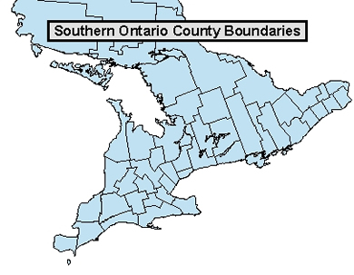
So, from the Ontario Road Maps site, take 1971

71York.jpg


The "coloured county" prime time--Metro's separate, but more as a unitary municipality than anything; otherwise, no different from the "over 10000 population" yellowness of Barrie, Aurora, Richmond Hill. And brand-new York Region's tokenly depicted; but otherwise, the pre-regional conditions within are maintained. As the official road map, this was pretty much the "public face" of Ontario, geographically speaking--an era when it was all about counties and the places within, places with symbols indicating population size (and in the index, they gave the populations--yes, it was deemed "officially" meaningful). And, this is when cities/towns/villages/police villages were cities/towns/villages/police villages, they weren't hyperactively subsumed into big blocs of municipality (well, actually, they secretly *were* at this moment, in York--you couldn't tell from this map that Markham was now a big blob of 20/30/40 thousand or whatever it was at that moment). And there was a certain geographic sensuality about this pattern: these weren't just dry administrative abstractions--this was an era when the sense of place(s) was still quite "nucleated" in a pre-sprawl fashion: a pattern that would have made Ebenezer Howard happy, I suppose.

Then, compare to 1999...

Elora.jpg


...now we're in the aimlessness of the post-nucleated era, where there's lots of dots indicating "places", but scarcely any hint of substance (other than grade of font) beyond that; where county/regional boundaries have degenerated to grey lines that are scarcely much thicker than whatever token municipal boundaries within; where "urbanity" is but blobs of orange (and populations? who cares); all in all, a dreary demonstration of how none of that cartographical Ontarioscape stuff that seemed to "matter" in 1971 much mattered anymore. Including the official Ontario map itself, which in a MapArt era on the verge of GPS universality came across as a skimpy autopilot anachronism. (Though one thing I'll say even on behalf of the latter map: if "city" were so separate from "county" as it is in Virginia, then Guelph would have a thick grey line around it, not a thin one.)

It's perhaps in this latter era that such excessively "administrative" views of political structure are conditioned, i.e. the inherent geographic sensuality of the 1971 map is, to the freshcutgrass/howl crowd (and needless to say, those younger), a grandfatherly anachronism.

However, it may plug back into the thread, if we read into any real-or-hypothetical deamalgamation sentiment (maybe more so in the late 90s than now, i.e. the scorched-earth Sewellite greybeard-and-biddy wing of the C4LD bunch)...maybe it is a longing for that 1971-and-even-earlier era, taken a few Jane Jacobite steps further to the point where Megacity decomposes into a flurry of reconstituted Mimicos and Westons and Leasides and municipalities-that-never-were. A municipal" re-nucleation": Toronto as a network of Gousha-esque place-indicators. (Heck, one net result of Montreal's amalgamation-and-then-deamalgamation is that even what's left of Montreal has mentally decomposed to the point where "borough identification" is almost stronger relative to "unitary municipal identification" than it's ever been.)
 
Well, I definitely underestimated your self-proclaimed map-geekiness. he he

If it were a topic I had more interest in, you'd be the go-to guy, that's for sure. But alas....
 
Maybe I'm more shocked that if you're my age or older and have this much interest in the stuff of municipal politics, that you would have survived the 60s and 70s in Ontario with absolutely no "active" engagement whatsoever to maps or whatever they conveyed--it's like everything you learned, you learned dryly, through some sort of political science academics. Look: maps are the essential sourdough starter here, they're what give the mass-resonant "kick". They're not to be merely dismissed the way a Weather Report fan would dismiss the Archies, Lester Bangs be damned.

So...take my word for it. Keeping in mind, too, that it's a map-geekiness with a, shall we say, "social history" bent. And with this in mind, even to the point where I'm able to plug it into the thread subject.

Because if you in any way comprehend maps as something that either project or reflect data to or from the general public, you'll recognize that they're more immediate, resonant, and "definitive" than mere administrative detail. And, heck--maps reflect what they, even those in charge of administration and whatever else, want you, the beholder and consumer of data, to perceive. That's why I continually emphasize that even if the administrative story says something different, show me a map, even one that serves a more than general-purpose demographic, that clearly delineates the separation of city and county in Ontario. (And don't use a case like present-day Brantford vs Brant County--that's cheating.)

Almost certainly, you won't find it for Ontario.

virginia-county-map.gif


But you'll definitely find it for Virginia. Get the hint?
 
The Virginia map was drawn to highlight the municipal boundaries. You need to compare it to a similar map for Ontario, not some crudely drawn map from the internet.
Map2.jpg
 
71York.jpg


this was an era when the sense of place(s) was still quite "nucleated" in a pre-sprawl fashion: a pattern that would have made Ebenezer Howard happy, I suppose.

Actually, the 905 is still quite "nucleated" in ppl's perception compared to the 416 even today. The old settlements are still shown on present-day maps there, or have even been added for some not shown before (Langstaff, Buttonville, Millikn). The 905 cities have an atmosphere of archaic ruralness that time and development hasn't erased. This is reflected in entymology (eg: the Hwy. 10 vs. Hurontario thing), political structure (Markham being a town despite having a population of a quarter million), and telecoms setup, such as the old settlements still having local phone exchanges/rate centres.
 

Back
Top