News   Apr 18, 2024
 691     0 
News   Apr 18, 2024
 6.1K     2 
News   Apr 18, 2024
 2.4K     4 

Union Station LRT Loop Reconfiguration (TTC, Proposed)

With the streetcars as delayed as they are, maybe reducing the current Bombardier order and ordering some double-ended cars to make reconstruction easier is worth reconsideration.

Unfortunate that the curve south of Queens Quay station is so tight, limiting the "off-the-shelf-ness" of any vehicles that could be ordered.

Yep, and maybe we can tell them to do it pro bono. Or the Feds can tell em to do it as part of a future bailout. One thing that bugs me a bit is that the EBF LRT study was done entirely separate from the Lower Yonge Precinct plan. In the EBF reports, there's little acknowledgements of how the street grid bounded by Yonge, Jarvis, USRC and QQE will be reconfigured in the future. Or how a Harbour Street extension bisecting the precinct would exist. We now know how it will exist.

Both the EBF precinct and Lower Yonge precinct are absolutely massive redevelopments, and it makes sense to undertake them as different planning areas. But I personally think that with Lower Yonge's plans now completed, we should reexamine unexplored options for bringing the lrt line to Union (or at least close to Union). Naturally this will take longer than people want, but I think it's worth it in the long run. We want to do it right, and IMO a walkalator ain't it.

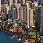
2015 Lower Yonge Precinct plan
6285_lower_yonge_conceptual_alternatives_2_4diagrams_1_870_450_both_.jpg

4830_new_boundary_image_1_870_450_both_.jpg


2013 LRT Alternatives (notice no Harbour Street extension included):

east-bayfront-lrt-2013-alternatives.jpg


Perhaps there's little reason to include a Harour Street extension in any plans. But I think with the changes to Lower Yonge's street network that we'll see, combined with bi-directional Flexity LRVs, there's potential for some other configuration. Example: a surface terminus south of Union with crossover tail tracks (and no need for a loop).
 

Attachments

  • east-bayfront-lrt-2013-alternatives.jpg
    east-bayfront-lrt-2013-alternatives.jpg
    103.9 KB · Views: 1,143
Last edited:
In Scarbrough, a transfer the width of a subway is an unfathomable injustice, but for the waterfront a transfer more than half a kilometre long is A-OK.

This right here fully embodies the madness of transit planning in Toronto.

I think the TTC has some tough decisions to make here (but pretty enviable to a lot of other transit authorities...oh no...my streetcar is too busy!)

This portal will be used to:
- get to/from the GO bus terminal in a couple of years
- expanded short commutes to/from the Ferry Docks station...both residential and commercial
- the 509/510 streetcar and the growth of usage
- a Portlands streetcar (probably one line running to Cherry and the other through the Portlands in the long term
- The WWLRT has a natural terminus here (either via QQ or via Bremner)

As many people on this site can attest even right now it is at capacity and people can't board/disembark fast enough which causes trains waiting to unload. Just with another stop in the tunnel (Go Bus terminal) and the backlog will be enormous

When I use to take this line in the summer from the CBD I use to walk south along York to the York or Harbourfront to travel westbound just to avoid the wait at Union (often 3 or 4 trains).

I can see 2 solutions:
1. A 4-track/2 platform solution with dual-end streetcars as a terminus station. Will cost hundreds of millions but allow for enough capacity for all these lines converging. There would also be another bottleneck...the Y at the south end of the tunnel (plus potentially a dangerous Y with the elevation change and the sharp corners. This also creates a danger at the Ferry Docks with the increased traffic and everyone crossing the tracks.

2. A travelator. Think of Pearson with a slow multi-stop one and a fast one (YYZ goes 8 km/hr but the technology can probably go up to 10 or 12 km/hr). The slow one could stop at the bus terminal, ferry docks and the fast one would go from one end to the other. About 4 minutes from one end to the other without walking (3 with). I wonder if someone could time a fast and a slow time through the tunnel right now to compare?

There is the facts (travel time, cost, etc) but there is also a perception issue. On cost and time I don't think we lose much travel time compared to cost. But the perception is bad...do I want to walk 1/2 km (even if I know its not really walking, just standing)
 
An extended Church Street with track/overhead (per the Lower Yonge Plan and assuming the gradients could work at both sides) could be the linkage between QQE and the wider network. It would leave a 500 metre transit gap to fill between Cooper St and Bay St but that seems less intrusive than taking a wrecking ball to Bay and Queens Quay.
 
I've never been so mystified by a "transit plan" like this since the Sheppard subway, so I decided to tip off one of the news outlets about this ridiculous plan. It may be a long shot hoping for them to investigate or pick it up, but this plan is on another level of pathetic transit planning in Toronto.
 
The YYZ super fast travelator goes 7km/h top speed...so 500m would be about 4-5 minutes...the longest travelator in the world is 800m...so this would be on the upper end of travelators. Maintenance would be a pain, because unlike YYZ where people have been inside for a long period of time before using it this is unlikely in downtown Toronto where people will be coming in from the slush and directly boarding it.

Obviously if it's down it's now a 500m walk - so they likely need more than 2 of them (4 or 6).

This seems like a case of nobody wants to put up the money for a product that everyone is responsible for offering...

Waterfront Toronto - will be a joke if this gets built as a travelator...so much for world class...
TTC - has already shown they are a joke by getting us into this situation, and now by offering this crazy idea as a solution
Toronto Planning - doesn't seem to have produced any workable plans, and has let the old ones get stale during the Ford years (they should have updated plans for this area ready to go)
Toronto Council - has already shown they are dysfunctional and basically nobody reads the plans anyways
Toronto Mayor - SmartTrak!!!
Province - seems to have offered money as an election promise - but nothing concrete - typical
Metrolinx - doesn't seem to be their problem since this isn't regional
Feds - early days, we haven't realized yet that none of their election promises with regards to money for transit will never happen
 
I've never been so mystified by a "transit plan" like this since the Sheppard subway, so I decided to tip off one of the news outlets about this ridiculous plan. It may be a long shot hoping for them to investigate or pick it up, but this plan is on another level of pathetic transit planning in Toronto.

This proposal sounds outrageous. I can't think of anything that better embodies the distinction in this city. I fully expect the media to pick up the story and fan the flames. I'm hopeful that the proposal will ultimately be scrapped once the public hears about it.
 
This proposal sounds outrageous. I can't think of anything that better embodies the distinction in this city. I fully expect the media to pick up the story and fan the flames. I'm hopeful that the proposal will ultimately be scrapped once the public hears about it.

I think the media was going to be pretty harsh on the original plan once they and the public fully realized what was to happen. $600M, 2-3 year closure of Union Loop, loss of 509 service (right after it reopened from the previous multi-year shutdown). And I don't think buses can drive on QQW's ROW, so we'd have that sitting empty for three summers. Seems like dark times on the waterfront any which way we cut it.

Edit: skimmed some of the Lower Yonge EA. Jaw dropping when you think what's being left high and dry here, and beyond into the LDL and Port Lands. Tho I believe some of these shown have been lowered in height (but with the same overall densities). I still firmly believe the EBF-LRT + Loop rebuild wouldn't be sufficient, and that we should be looking to grade-separate some or most of the 2km between Bay and Cherry.

Lower-Yonge-Precinct-Urban-Form-2.jpg

Lower-Yonge-Precinct-Urban-Form-3.jpg
 

Attachments

  • Lower-Yonge-Precinct-Urban-Form-2.jpg
    Lower-Yonge-Precinct-Urban-Form-2.jpg
    152.3 KB · Views: 933
  • Lower-Yonge-Precinct-Urban-Form-3.jpg
    Lower-Yonge-Precinct-Urban-Form-3.jpg
    156.9 KB · Views: 935
Last edited:
Re-purposing the existing streetcar tunnel for travellator is a non-starter.

Travellator may be not a bad idea per se, if it was built from scratch. For people heading from Union to Ferry Docks, travellator would actually be more convenient than streetcar, as there would be no wait. But this is not a situation of building from scratch.

I posted about this many pages ago but I'll throw it to the wolves again. My preference is to have the portal surface in front of the ACC, Bay St transit mall up to Queen and loop around old city hall.

I like the transit mall proposal. However, what does anyone think about an option with smallest amount of changes?

- Transit mall on Bay, from Queen's Quay to Queen
- Only Bayfront East streetcars run there
- Car type: either regular single-cabin, and looping around the old City Hall; or, custom made double-ended cars
- Waterfront West streetcars 509 and 510 continue to operate as today, using the tunnel under Bay and underground loop at Union

Thus, there will be no disruption in the 509 / 510 service during the construction period.

One potential concern is whether the structure of Bay tunnel can support another streetcar line running at the street level. I hope it can, as it was probably built to withstand any kind of surface traffic including heavy trucks.
 
Re-purposing the existing streetcar tunnel for travellator is a non-starter.

Travellator may be not a bad idea per se, if it was built from scratch. For people heading from Union to Ferry Docks, travellator would actually be more convenient than streetcar, as there would be no wait. But this is not a situation of building from scratch.

I like the transit mall proposal. However, what does anyone think about an option with smallest amount of changes?

- Transit mall on Bay, from Queen's Quay to Queen
- Only Bayfront East streetcars run there
- Car type: either regular single-cabin, and looping around the old City Hall; or, custom made double-ended cars
- Waterfront West streetcars 509 and 510 continue to operate as today, using the tunnel under Bay and underground loop at Union

Thus, there will be no disruption in the 509 / 510 service during the construction period.

One potential concern is whether the structure of Bay tunnel can support another streetcar line running at the street level. I hope it can, as it was probably built to withstand any kind of surface traffic including heavy trucks.

So, in your version does Waterfront East house cars / loop around under the new 81 Bay Hines building?

To me, you have two separate things in your proposal: a 'transit mall' that will take out a significant north/south route for cars, and therefore attract Ford/DMW condemnation and histrionics. But, second, you have a new LRT for QQE that begins and ends (well, hopefully it gets attached to the Cherry Street loop, but for the moment) in two massive developments with the same deep pockets developer, where Hines has already proposed GO Buses and an LRT station.

So -- why not take out all the histrionics and hyperbole, and route QQE LRT to the new Bay GO bus station, with a +15 PATH connection to Union. Leave QQW LRT as-is, no changes, no disruption, no cockamamie moving sidewalk. Leave Bay street as-is, with the transit mall concept shelved until further notice.

Doesn't that make sense? What am I missing?
 
The slush/dirt issue with a high-speed moving walkway is a valid and very serious point; I don't want it to get lost in this discussion. At Pearson, people are walking on carpet and wearing clean shoes. It works there very well. As soon as dirt, snow, salt, or ice get stuck in between the moving elements of the plates as they separate to accelerate/decelerate (remember, this is a very different technology from conventional escalators/moving walkways), it's going to fuck up. There's no sidestepping that.

Also please stop calling it the "Heathrow T5" peoplemover. Just because that's the only one you've riden doesn't mean it doesn't exist elsewhere. :) Phoenix SkyHarbor and DFW etc are mad at you. It's called Innovia APM. It's a total re-think of the 40-year old Wesinghouse APM's that you can find at dozens of airports around the world, to make the infrastructure far simpler (flat concrete pad, one centre guide rail, done). Siemens did the same thing by updating their relatively complicated VAL to a new much simpler system called CityVal (Rennes Ligne B, under construction, is the launch customer). I'd also suggest the TTC look into that (CityVal).

Airport APM's move a shitload of people very rapidly and very frequently. Anyone who's been through ATL knows what I'm talking about!
 
Also please stop calling it the "Heathrow T5" peoplemover. Just because that's the only one you've riden doesn't mean it doesn't exist elsewhere. :)
I was making a distinction between the T5 APM and that PRT thing they have and which someone, perhaps on another board, thought I meant in a discussion on this. Also, I wasn't suggesting it had to be Innovia, but having the characteristics of the implementation at Heathrow - subgrade, ATO, platform doors, one or more intermediate stops.
 
I'm just saying that what Heathrow has as inter-terminal at T5 (INNOVIA APM) isn't specialized or anything to this discussion, it's just adding confusion. Many airports have similar high-speed, ultra high capacity APM's.

As much as I like the T5 Business Park PRT (ULTra PRT), as you say, it's not suitable for surge loading and is best used in grid-like deployments, circulators, commercial parks, etc with lots of different start and end points (not hub-and-spoke).
 
So based on the comments in here I'm assuming we all agree that the crush load to the Ferry Terminal messes up the entire QQ streetcar network? And if we could offload people just taking the streetcar to and from Queens Quay Terminal the lines would function better?
 
So based on the comments in here I'm assuming we all agree that the crush load to the Ferry Terminal messes up the entire QQ streetcar network? And if we could offload people just taking the streetcar to and from Queens Quay Terminal the lines would function better?

I don't think so at all--I made a comment of that nature only under the condition that they leave the 509/510 running and have a moving walkway for the LRTs. I think as it currently is, it's not optimal having all of those people cram the streetcar for only one stop, but it's not a massive impediment at all. I generally find that it's only ever a problem not due to residents or employees working there but due to tourists going to the ferries--when that's an issue, the service is frequent enough that when I can't board a 509 due to it being full, the next one is just a minute or two behind and ends up having room, and the LFLRVs always have room especially because the tourists all board at the front 2 doors leaving regular riders to go to the rear 2.

Additionally, when tourists cram on the 509 to go to the ferry docks, usually less than 5% of them are willing to board a 510 because they don't seem able to understand the route maps and think it doesn't serve any of the same stops--often I simply take a 510 to Spadina, maybe get a drink at Starbucks, and just hop on the 509 behind it which is usually almost empty by then.

It certainly wouldn't hurt to remove the ferry docks stop and have the streetcars, once underground, just deadhead to Union, but I don't see that happening. Personally, I very rarely take it that one stop--especially now that the path connection through the ACC to RBC is open.
 
So, in your version does Waterfront East house cars / loop around under the new 81 Bay Hines building?

To me, you have two separate things in your proposal: a 'transit mall' that will take out a significant north/south route for cars, and therefore attract Ford/DMW condemnation and histrionics. But, second, you have a new LRT for QQE that begins and ends (well, hopefully it gets attached to the Cherry Street loop, but for the moment) in two massive developments with the same deep pockets developer, where Hines has already proposed GO Buses and an LRT station.

So -- why not take out all the histrionics and hyperbole, and route QQE LRT to the new Bay GO bus station, with a +15 PATH connection to Union. Leave QQW LRT as-is, no changes, no disruption, no cockamamie moving sidewalk. Leave Bay street as-is, with the transit mall concept shelved until further notice.

Doesn't that make sense? What am I missing?

Routing QQE LRT to the new Bay GO bus station is nice. But, how will it get there? On-street in mixed traffic? Or, using a new tunnel that has to be built for that purpose?
 

Back
Top