Whatever corridor accepts and elevated line would be the likely winner.
If Toronto goes forward with a
$6.8B DRL from Pape to City Hall (that's 7km, or $1B/km), I do not know if they will get much support - especially since that short length won't really do much relieving. It will just allow headway on the Yonge line to be reduced by 10 or 15 seconds due to fewer transfers, but won't take anyone off the Yonge Line.
I haven't seen a recent estimate for the DRL long, but at these prices, or the $700M/km that is the SSE, it would likely be huge. Maybe 5km from City Hall to Dundas West @ $1B/km, and 11km from Pape to Fairview @700M/km, it would work out to $6.8B + $5.0B + $7.8B = $20B. Mount Dennis area would add another $3B.
Toronto has completely lost their minds when they are planning the 5km long SSE for $3.5B ($700M/km) and the DRL short for $6.8B and a DRL long from Mount Dennis to Fairview costing well over $20B. We need to look at Vancouver and now Montreal. Elevated is the way to go. Vancouver prices with some elevated, some underground come in at about $150M/km. We can build 4 to 7 times more for the same money.
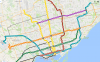
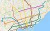
Essentially, what is preferred for $13B:
The 1 stop SSE plus the DRL short from Pape to City Hall, (about 12km) or
These two DRL's, one from Malvern to Sunnyside and the other from Seneca to Pearson or Pioneer Village (about 70km).