News   Dec 19, 2024
 799     3 
News   Dec 19, 2024
 682     0 
News   Dec 19, 2024
 811     2 

Transit Fantasy Maps

Because Queen is too far from the Financial District.

But Queen is central to virtually everywhere else (Chinatown, Queen West, Fashion District, Entertainment District, Art Design District, northern side of Liberty Village, Parkdale, Regent Park, Corktown, Riverdale, Leslieville) and is easily walkable/bus-able to either Dundas or King Streets through the central stretch from Ossington to River Street. Anyhow, considering that the likelihood of there ever being two subway lines built downtown within our lifetimes is slim, I propose this:


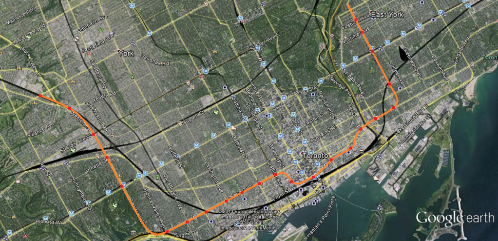
As you can see, the subway follows Queen Street until Spadina, thereafter it diverts via John south and follows Front (direct Union connection underneath the existing platform) through to St Lawrence Market and the Distillery District before following King up to Queen and across to Carlaw. Then it diverts north on Pape following the conventional DRL alignment to Eglinton (or to Seneca Hill long term). All major nodes covered.
 
Those turns are way, way too tight. The TTC absolutely despises the turn at the bottom of the YUS line and would not accept a plan like that. large turning radii only.
 
Yes. Very large radii. See Spadina Subway extension and Scarborough Subway extension.

Even the curves at Roncesvalles and the one just south of what I believe is Pape Station looks to be tighter than what the TTC would ever build.

Small radii puts extra strain on the tracks and trains and means that trains can't pass at full speed.

[As a side note: I love that word radii ;)]
 
If you want a more 'natural' curve in the west end, use either the rail corridor or Niagara St to go from Queen down to Wellington. And yes, I still prefer Wellington as opposed to Front. With Front, you would need a massive rebuild of the recently massively rebuilt Union station. I don't think businesses along there would like to see Front torn up twice in a 10 year span. With Wellington, all you need is a walkway connection. You also get connections to King and St. Andrew that way.
 
neither of which are remotely convenient for anyone making that transfer, of which there will be a fair amount. King street is still my preferred location, it would allow for easy transfers between the 1 and (possibly) 3 lines.

Queen is more suited for a streetcar than King is anyway, I wouldn't want the subway on Queen simply for that reason.

I really don't think there will be a high transfer volume, except to Union GO. Downtown is a destination. Most riders on the DRL in the AM peak will be originating from the ends of the line (transferring onto it at Pape/Donlands and whatever the western B-D intersection is), which means they'll be using the DRL because it's a more convenient way to get downtown. If they were bound for Wellesley, College, or Dundas, I would assume most people would stay on Bloor-Danforth and transfer at Bloor-Yonge like they do now. Using the DRL would add a transfer, which most people would avoid.
 
There are plenty of people who will be entering the system along the DRL that will want to transfer. It won't be Bloor-Yonge, but the transfer levels would still be significant. If i lived at the future Bathurst station and wanted to head to NYCC, I would transfer at the interchange.
 
There are plenty of people who will be entering the system along the DRL that will want to transfer. It won't be Bloor-Yonge, but the transfer levels would still be significant. If i lived at the future Bathurst station and wanted to head to NYCC, I would transfer at the interchange.

Yes. Even if it the DRL goes only down to Spadina & King or Spadina & Wellington, many people would transfer to the DRL at King station to take it west to Spadina.

There are a huge amount of jobs & other destinations (restaurants etc) around the King-Queen Spadina-Bathurst area. Taking the DRL to Spadina and walking from there is likely going to be more attractive than taking the Queen or King streetcars, or walking from St Andrew.

If it goes one more stop to Bathurst, it will get even more ridership from the YUS line transferring at King & St Andrew, because it becomes even more useful as an alternative to streetcars.
 
Also, If I'm coming from say, Liberty Village and heading to the Eaton centre, I will probably be transferring, even if it is just for 1 or 2 stops. Faster than taking the Queen streetcar or walking, especially since the Yonge line will be closer to 90 second frequencies at this point. It won't be used for long distance commuting as much as just travel through the downtown area.
 
Just an Idea for WWLRT routing and how the tighe spaces could be dealt with. Route would follow queens quay ROW to fleet and fort york where it dips underground in shallow cut and cover tunnel to cross lakeshore (to preserve Prince's Gates sightlines). It hugs the south side and might eat up a little bit of Coronation Park and Battery Park space just wide enough for ROW and a stop at the end of Strachan. Remembrance Drive is deleted from the area. The route then goes through the Ontario Place parking lots until Ontario Drive where it cuts on elevated structure to the small berm behind Scadding Cabin and Liberty Grand on north side of LS. At Dunn avenue it crosses Gardiner and runs along elevated structure which cantilevers over the expressway to provide clearance for double decker trains. At roncesvalles the line cross Gardiner again to end up in the grassy berm between LS and the highway and finally starts running in the current grassy median of LS until the humber where a new nondescript bridge runs on southside of current ones to not take away from the lovely pedestrian arch bridge. Bridge lands behind Palace Pier Condo and continues on current 501 Lake shore Blvd routing till the end.

Potential loop at Christie Factory lands.


Thoughts? Is the bit between the Gardiner and rail corridor even technically possible?

PS sorry the post is so long :p

princess gates.jpg
Ontario place west.jpg
LS to gardiner.jpg
club house.jpg
sunnyside transition.jpg
sunny side median.jpg
sunny side median to humber.jpg
humber bridge.jpg
 

Attachments

  • princess gates.jpg
    princess gates.jpg
    106.2 KB · Views: 540
  • Ontario place west.jpg
    Ontario place west.jpg
    104.6 KB · Views: 567
  • LS to gardiner.jpg
    LS to gardiner.jpg
    104.5 KB · Views: 561
  • club house.jpg
    club house.jpg
    105.8 KB · Views: 560
  • sunnyside transition.jpg
    sunnyside transition.jpg
    104.2 KB · Views: 518
  • sunny side median.jpg
    sunny side median.jpg
    102.2 KB · Views: 554
  • sunny side median to humber.jpg
    sunny side median to humber.jpg
    103 KB · Views: 531
  • humber bridge.jpg
    humber bridge.jpg
    102.8 KB · Views: 555
Also, If I'm coming from say, Liberty Village and heading to the Eaton centre, I will probably be transferring, even if it is just for 1 or 2 stops. Faster than taking the Queen streetcar or walking, especially since the Yonge line will be closer to 90 second frequencies at this point. It won't be used for long distance commuting as much as just travel through the downtown area.

Yeah subways are actually great for shorter distance travel, especially if you're downtown where the stations are closer together. When I had a metropass I'd regularly take the subway for short trips of 2-4 stations. The high frequencies of subways mean you're more likely to consider taking it over walking, and transfers are painless.

Yeah I was going to say that if the DRL reached Liberty Village, it would be a extremely useful, not just for the people who live there, but for those who work in the many offices there. Currently that area isn't easy to reach by transit, it's either the King streetcar or Dufferin bus. Neither has a great reputation.
 
Thoughts? Is the bit between the Gardiner and rail corridor even technically possible?

I'd check out the layout of the proposed alignment of Lakeshore Boulevard in the Western Waterfront Master Plan. Dowling Ave is planned to be closed to traffic and would be an ideal place for the WWLRT to cross over both the Gardiner and the rail corridor to make it to the north side.

I also don't particularly see the need for as many bridges and tunnels that you have in the alignment. In the east, it would be simpler to keep the streetcar right-of-way south of Lake Shore Boulevard instead of digging a tunnel under LSB just to it can cross again at-grade at Bathurst.

As well, I don't see any major issues with continuing to use the Queensway Streetcar ROW. There will never be any significant development south of the Gardiner between the Humber and Ontario Place.

If you really wanted to, you even could continue the LRT along the Queensway until it reaches Sherway Gardens. If there was ever a corridor that was ripe for development, it is this one.
 
If you want a more 'natural' curve in the west end, use either the rail corridor or Niagara St to go from Queen down to Wellington. And yes, I still prefer Wellington as opposed to Front. With Front, you would need a massive rebuild of the recently massively rebuilt Union station. I don't think businesses along there would like to see Front torn up twice in a 10 year span. With Wellington, all you need is a walkway connection. You also get connections to King and St. Andrew that way.

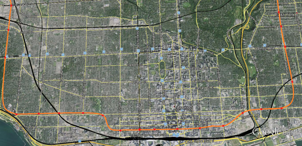
Ok, would something like this work?:


As you can see, I made the curvature/turning radii wider with the turns onto Queen from Pape and Parkside Dr starting well in advance of the stations at Logan and Roncesvalles. I used Niagara St as the transition in the west and gradually have the line curve up on a diagonal via Eastern from Front to Queen in the east.
 
Last edited:
you can't have stations on turns like that, and the bottom curve of that jump from wellington to Queen is still a bit tight, if not as tight as the bottom of the YUS line. Think gradual enough that trains don't have to slow down. may I suggest putting the Bathurst station at King, and slowly curving it up from there? I feel that alone would make a difference.
 

Back
Top