News   Dec 19, 2024
 652     3 
News   Dec 19, 2024
 592     0 
News   Dec 19, 2024
 745     1 

Transit Fantasy Maps

A what could have been for Detroit

http://detroitography.com/2014/01/31/updated-detroit-metro-transit-fantasy-map/

dm_invert_1800.png

MARK: This proposed rapid transit system for Detroit and Windsor is quite interesting...

This shows what could have been built if Detroit was not so auto-centric or dependent and I agree that a
tunnel route between Detroit and Windsor could have become a logistical as well as a Customs/Immigration problem...

To make this worthwhile they would need to honor border ID's like NEXUS and FAST cards as well as have their own
Commuter Clearance program for regular riders short of having a Schengen's Agreement between the US and Canada
(wishful thinking on my part) to make this transit option work...

LI MIKE
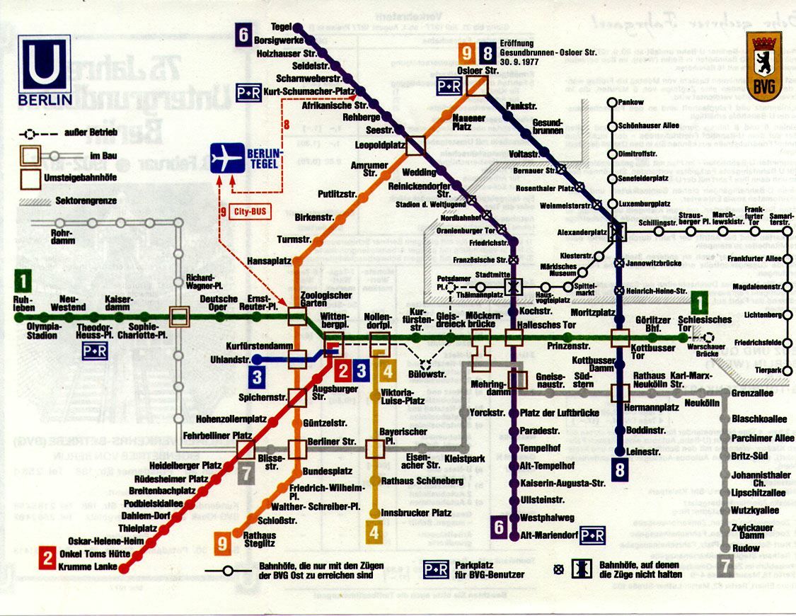
It would be interesting to see a subway system that operates in more than one country (though it would not be the first; Berlin's U-bahn served two countries during the partition).
 
It would be interesting to see a subway system that operates in more than one country (though it would not be the first; Berlin's U-bahn served two countries during the partition).

Though, after the Berlin Wall went up, the the two sector's transit systems were mostly disconnected. Lines from West Berlin were stopped prior to entering the eastern zones, but two lines were allowed to run through the eastern zone without stopping.

tumblr_m0l25x5Hil1r54c4oo1_1280.jpg
 
In a place like Windsor you could have only one station there where no one can be let out of the station unless they show their papers. And no one can get back in either.
 
In a place like Windsor you could have only one station there where no one can be let out of the station unless they show their papers. And no one can get back in either.

I envision it something like the Yellow line in Montreal at Berri-UQAM. To get to it, you need to go down a long escalator (it's a very deep platform). You could put a customs area on a separate concourse level above the platform but below the rest of the station. That way "national" traffic can continue on the upper levels unimpeded, while "international" traffic needs to go down a few levels. Same thing would exist on the other side.

Ultimately though, I don't think it's practical to have the international line be anything more than two stations, connecting to transit hubs on either side. Have them be the bottom level (or top level if it's above ground) of their respective station complexes. It would look like little more than a Times Square-Grand Central shuttle, but it would do the trick for transporting people from one transit hub to another, across an international border.
 
Playing around with a GO REX concept again:

APcRcf1.jpg


same legend as before, really thin (1 point) is hourly, 2 point is 30 minutes, 3 point is 15, and 4 point is 7.5 or better.

GEORGETOWN
Kitchener-Toronto: 30 minutes
Mount Pleasant-Toronto: 7.5 minutes
Airport-Toronto: 15 minutes

MILTON
Cambridge-Toronto: 1 hour
Milton-Toronto: 30 minutes
Lisgar-Toronto: 15 minutes
MCC-Toronto: 15 minutes

LAKESHORE WEST
Hamilton-Toronto: 3.75 minutes
Stoney Creek-Toronto: 15 minutes
Niagara-Toronto: 1 hour

BOLTON
Bolton-Toronto: 30 minutes
Highway 27-Toronto: 15 minutes

BARRIE
Barrie-Toronto: 1 hour
Green Lane-Toronto: 15 minutes

MIDTOWN
Pickering-MCC: 30 minutes
Pickering-Hamilton: 30 minutes

STOUFFVILLE
Uxbridge-Toronto: 1 hour
Stouffville-Toronto: 30 minutes
Mount Joy-Toronto: 7.5 minutes

LAKESHORE EAST:
Bowmanville-Toronto: 30 minutes
Oshawa-Toronto: 3.75 minutes

Frequencies double during rush hour with the exception of the UPX, which remains the same all day.

PEAK SERVICE:

Peterborough-Summerhill: 30 minutes
Pickering-Toronto: 15 minutes
Brantford-Toronto: 30 minutes
Bloomington-Toronto: 15 minutes (Richmond hill line)
Oshawa-MCC: 30 minutes (would use the CP tracks between my current Pickering terminus and the new oshawa station on the realigned lakeshore east route
Brampton-Pickering: 1 hour
 
Last edited:
Is there any way you can make the different lines different colours? It's kind of hard to see how your branching is going to work, especially in the west end around the Junction. Looks to be pretty similar to what I have though, except for you have the Midtown line and I have the DRL being a GO REX tunnel instead.
 
Okay, just for fun, here's my subway map for 2050. I've left out stations on the BD/YUS/Eglinton-Crosstown (which I mistakenly coloured purple), since we already know where they are. I also deliberately took out the GO-REX system otherwise it would have been too crowded. Nevertheless, you can see where the transfer stations are, since they're the ones that are labelled but don't seem to intersect with anything.

I added a mid-central subway line running roughly along Dundas to Regent Park, and then dipping down to serve a high density, revitalized Portlands.

The DRL runs roughly to the south of King street, taking advantage of streets like Douro, Wellington, Esplanade and Mill to serve as either TBM extraction sites or cut and cover rights of way. The "St. Andrew" station box for the DRL extends along Wellington from just west of Simcoe to about where Duncan would normally intersect. Oh, one more mistake: Cherry-Front is actually an intermodal station that includes a subway interchange plus a transfer to a GO-REX station.

Toronto_Downtown_Map.png
 
Last edited:
Instead of two parallel subway lines along Dundas and King, why not a single line along Queen equidistance to both?
 
Why not bring the Western Relief Line to Eglinton?

I thought it would be redundant to run a subway line parallel to eventual, high frequency GO-REX service between the Junction and Mount Dennis on the Kitchener line.

Actually, the only reason I thought of extending the western DRL to the Junction, instead of ending it at Dundas West is that I would like to see a regional rail super-station making use of the Junction, where passengers traveling on the CP-Midtown line could transfer to Weston sub trains. The equivalent would be something like Amsterdam Sloterdijk.

Instead of two parallel subway lines along Dundas and King, why not a single line along Queen equidistance to both?

Spacing the lines at Bloor, Dundas and King gives everyone from just south of Dupont to the lake a 600 meter north or south walk (~15 minutes) to a street with a subway line. When you add the Midtown GO-REX service and Lakeshore GO-REX service, it covers even more ground. Streetcar lines would be reoriented to provide North-South service: Lansdowne, Dufferin, Ossington, Jarvis, Parliament. It would sort of be like Manhattan, where there are multiple parallel north-south subway lines, but surface transit to cover much narrower east-west travel. Also, I'm anticipating that this is in the extreme future, where densities in the area south of Bloor approach Manhattan levels throughout.
 
Last edited:
Whatever street they choose, it should go up Roncesvalles to Dundas West station. In the alternative, they could use Dufferin for the north/south leg in the west end, but that street isn't a destination like Roncesvalles.
 

Back
Top