News   Jul 15, 2024
 190     0 
News   Jul 15, 2024
 515     0 
News   Jul 15, 2024
 620     1 

Transit Fantasy Maps

Updated my fantasy map to include some new transit realities:

1) With the Bloor-Danforth extension to Sheppard & McCowan now official city policy (for now), I needed to take that into account.

2) With the extension to Sheppard & McCowan, it makes the Sheppard East LRT less useless. The B-D extension also raises another interesting aspect: massive cancellation fees for the LRT vehicles from Bombardier. I believe the solution to this, however politically unpopular, is to convert the Sheppard Subway to handle LRT.

Now, normally the $600 million pricetag may scare people off, but considering that the cancellation costs could run over a hundred million anyway, that conversion cost becomes more attractive. This is so because if the Sheppard Subway is converted for LRT, the SLRT vehicles that were ordered can be shifted over to Sheppard, and the T1s currently on Sheppard can service the B-D extension, saving the City from having to order new train sets for that extension.

3) Because of the conversion, the Sheppard and Finch LRTs can be connected to create a single thru-line. I chose a routing along Bathurst, because it runs through some pretty decent density. It will also allow for the western extension of the NYCC density cluster away from Yonge.

Most of the other stuff you've probably seen from me before (interlining, Jane and Don Mills BRTs, WWLRT connecting to West Yonge extension at Queen & Dufferin, etc). If you have any questions, just ask!

MoveToronto_v7.jpg


EDIT: Bigger version here (https://dl.dropboxusercontent.com/u/43869799/MoveToronto_v7.jpg)
 

Attachments

  • MoveToronto_v7.jpg
    MoveToronto_v7.jpg
    99 KB · Views: 713
Updated my fantasy map to include some new transit realities:

1) With the Bloor-Danforth extension to Sheppard & McCowan now official city policy (for now), I needed to take that into account.

2) With the extension to Sheppard & McCowan, it makes the Sheppard East LRT less useless. The B-D extension also raises another interesting aspect: massive cancellation fees for the LRT vehicles from Bombardier. I believe the solution to this, however politically unpopular, is to convert the Sheppard Subway to handle LRT.

Now, normally the $600 million pricetag may scare people off, but considering that the cancellation costs could run over a hundred million anyway, that conversion cost becomes more attractive. This is so because if the Sheppard Subway is converted for LRT, the SLRT vehicles that were ordered can be shifted over to Sheppard, and the T1s currently on Sheppard can service the B-D extension, saving the City from having to order new train sets for that extension.

3) Because of the conversion, the Sheppard and Finch LRTs can be connected to create a single thru-line. I chose a routing along Bathurst, because it runs through some pretty decent density. It will also allow for the western extension of the NYCC density cluster away from Yonge.
g[/url])

I'm with you on the Sheppard finch lrt through line, however I'm not sure about bathurst. Let me be a dufferin advocate for a moment.

1. Using dufferin would be easy to do since there are already brt lanes there.

2. The through line would make sense to turn north After hitting Sheppard west (downsview) station for connection reasons system wise.

3. *a bus has to run on bathurst no matter what. However if you chose dufferin the dufferin bus frequency could be vastly limited since only between finch and Steeles would not be covered.

It's really an either-or for the north-south stretch. Both work. I've shown it running up Dufferin in the past. I just figured Bathurst also made sense because at least you're serving a new area, as opposed to running down Dufferin which for a good stretch of it it's a duplication of service considering walking distances to Downsview and Downsview Park stations.

Also provides for the extension of the NYCC cluster further westward, as I mentioned above.

But you're right, a good case can be made for Dufferin as well.
 
What are the odds that the official TTC subway map will feature the Eglinton LRT line, as seen in Ramako's maps?

I would say it's a good chance at least the underground portion will be on the map, as it is "rapid transit".
 
I would say it's a good chance at least the underground portion will be on the map, as it is "rapid transit".

The TTC isn't just going to erase half of the ECLRT just because it's above ground.

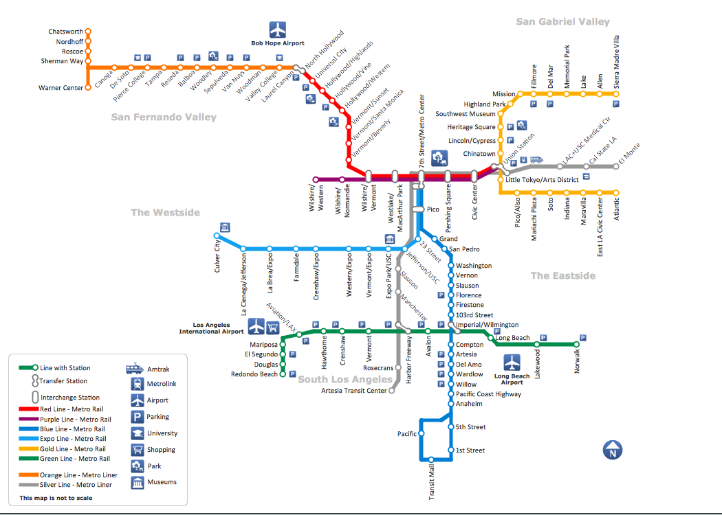
I hope the TTC follows LAs example and does this:

Metro_Rail_and_Liner_Los_Angeles_Map.png


There are subway and LRT lines on that map. But you can't tell the difference. It should be this way. LRT isn't a lesser form of transit. It literally only takes seconds longer to travel Don Mills - Kennedy on LRT than subway. They both get people where they're going quickly, and that's all that matters.
 
Last edited:
Toronto should be following LA's example when it comes to transit? This is sad.

The TTC subway/RT system is not defined by being underground. A lot of it above ground anyways. The system is defined grade by fare-paid zones. If a line doesn't have fare-paid zones, then it's not part of the system, simple as that. If they start adding all "LRT" lines then they'd have to start adding all the "streetcar" lines too, where does it end?
 
Last edited:
I meant the design of the map. Not the actual transit (or whatever you were referring to). I could pick another transit map from another city to make an example of if that will make you happy.

Which other system map includes both full subway and surface light rail on their maps and makes them indistinguishable from each other?

If TTC is to follow LA's example, then BRT should be included too, since the Orange Line is BRT.
 
Which other system map includes both full subway and surface light rail on their maps and makes them indistinguishable from each other?

If TTC is to follow LA's example, then BRT should be included too, since the Orange Line is BRT.

I believe Shangahi does the same thing as well.

But that's not my point. What I'm trying to say is LRT isn't second class transit. In the case of the ECLRT, the travel time difference of the LRT vs Subway comes down to mere seconds. It should be given equal representation on our maps as subway.

Furthermore, there is no benefit to customers of hiding the fact that the Eglinton Crosstown, Finch and Sheppard LRT lines exist (if there is one, please point it out to me). Nobody but a few transit geeks here on UT care that it will take 25 seconds longer to get to Victoria Park on the LRT than it would if there was a subway. All that real customers care about is where our LRT/Subway system will take them.

By the way, we have to be very careful about comparing LRT lines around the world. In many cases, what is called LRT in some parts of the world would actually be a subway here. And in many more places, what is called an LRT would actually be a streetcar here. The closest example that I've seen to what Toronto is getting is the Los Angles LRT system. Like our LRT, it has segments that run underground and the at-grade sections run exclusively in a separated ROW. But the LA LRT isn't a perfect analog. The major difference is that their LRT does not have signal priority throughout the entire line. We'll have that here in Toronto which should mean much faster travel times.
 
By the way, it should also be pointed out that the idea that the LRT lines shouldn't be included on maps is even crazier when you consider than parts of our subways system move slower than the LRTs will. Thankfully nobody is recommending erasing the Yonge subway from the map.
 
Yonge subway operates much faster than 24km/h, with the exception of passing Davisville.

The RT replacement will operate at 35km/h only because it is grade separated, and the Yonge subway really only operates 1km/h slower than that.
 
Yonge subway operates much faster than 24km/h, with the exception of passing Davisville.

The RT replacement will operate at 35km/h only because it is grade separated, and the Yonge subway really only operates 1km/h slower than that.


If my memory is correct, the ECLRT (ROW/underground) operates at an average speed of 28 km/h, while the underground Eglinton LRT would operate at 30 km/h.

Update 1: I was referring to Yonge south of college. I believe the average operational speed is less than 20kph on that segment.

Update 2: My memory failed me: The at grade LRT runs at 22kph. That means that it should take about 90-120 seconds longer (give or take) on the at grade LRT to get to Victoria Park from Kennedy vs underground LRT. A little slower, but not a dramatic speed difference. Completely removing the line from the map because of a few seconds is a tad ridiculous.
 
Last edited:
I think putting all the LRTs on the map would be insane. They don't belong on the subway map. Of course they'll go on the system-wide map, but it would be frankly disingenuous and misleading to put them on a subway map.

I'd be fine with doing it the way Boston does it.
 
I think putting all the LRTs on the map would be insane. They don't belong on the subway map. Of course they'll go on the system-wide map,...

I'd be fine with doing it the way Boston does it.

Maybe I need to be more specific. We're talking about the maps that the TTC will be using in our subway and LRT fleet. For example, the Subway/RT Route Map in cars today.

Of course the TTC shouldn't be putting the LRT lines on a subway map. The only three subway lines in Toronto are Sheppard, Yonge-University-Spadina and the Bloor-Danforth. However, the TTC hasn't publicly used subway exclusive maps for almost 30 years. The closest thing they have is their "Subway/RT Route Map" that are used on our subway fleet. It features our SRT, BD, YUS, and Sheppard lines. The SRT is not a subway. They switched over to that map when the SRT opened in the 80s. I see no reason why they won't do the same now with the LRT. Especially since TTC/Metrolinx have been pushing it as a cheaper, but fast alternative to expensive subways (which is exactly what it is).


but it would be frankly disingenuous and misleading to put them on a subway map.

Who would it be misleading and how? It's not like these things are bus/streetcar routes, where it can literally take 30 minutes to travel 1 km. These are LRTs which in practice should have a trivial speed difference when compared to heavy rail.

What's misleading is omitting the LRT lines and making people falsely believe that there's no transit in those areas.

Imagine the complains when thousands of customers spend twice or three times as long as they need to travelling because someone decided that LRTs, which are almost as fast and operate nearly identically to subways, weren't good enough for our Subway/(L)RT Route Map.
 
Last edited:

Back
Top