News   Apr 25, 2024
 360     0 
News   Apr 25, 2024
 1.1K     4 
News   Apr 25, 2024
 1K     0 

Toronto Urban Sprawl Compared to Other Cities

I've always wondered why Toronto's inner suburbs have so many high rise buildings. I haven't seen that in any other city in North America.

Actually, most Ontario cities are like that. You can see it in Mississauga, Brampton, Hamilton, London, Ottawa... It's mostly 50s and 60s, although some of the Kaneff buildings in Mississauga are from the early 70s. I think same with Brampton. I remember someone on this forum saying they stopped building them because of rent control, but now apartments are being built en masse again as condominiums.

As of 2011 Census, 35% of households in Mississauga lived in apartments (compared to 39% in detached houses). I wouldn't be surprised if it was over 50% in Etobicoke, North York, and Scarborough.

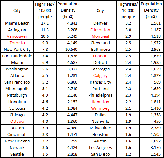
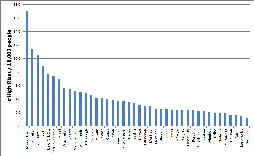
Mississauga has over 250 high rise buildings (10 storeys or higher), North York is around 500, Scarborough around 300, and Etobicoke over 200 (slightly less than Mississauga). North York has more high-rises than Honolulu, Boston, Philadelphia, etc.

More than half of the high-rises in the Toronto metropolitan area are located in the post-war suburbs. I don't think you can say the same for many other metropolitan areas in North America.
 
Canadian sub/urban areas: More high-rise buildings then comparable US cities...

Canadian cities in general have much more highrises per capita than American cities. Toronto is the king of this trend, but not the exception. It comes down to highway miles per capita is my opinion. It would he interesting to make a scatterplot of highway miles per capita and highrises per capita. I might just do it!

I'll try to find the link but I remember reading an article a few months ago stating that about 20% of Canadians live in commieblocks!

MJ and Salsa: I agree with you both on this observation - Canadian cities tend to have a mix of housing types in a wide variety from apartment
buildings to single family homes - in some cases near one another and in both urban and suburban areas - the best example to me of growth
are both Mississauga's and the new Markham city centers in the Toronto area - and Markham's in particular reminded me of the Nassau County
Hub Lighthouse Project that was basically all but shelved permanently by Nassau's government...

To construct higher density housing or apartment buildings on Long Island for example you would need changes in zoning for starters and to
satistfy NIMBY opposition to any thought of urban or city type construction in everything from school districts enrolling more children to more
traffic...I am for revitalizing older LI "Downtown" areas in any positive way possible but many Long Islanders still think of the traditional one
family house as what they want no matter what the costs are may they be auto dependency or sky high property taxes which is the #1 gripe
many have - including me...but I feel in time that this traditional suburbia may be unsustainable over time in many ways...

What I find interesting about Mississauga's building Downtown is that it has no rail transit serving it currently and is it Cooksville on the
Georgetown GO Line the closest station? The Hurontario LRT may be a good move for Mississauga in the future and it certainly is better
then how the proposed Nassau Hub would have been served - which would have been primarily auto dependency especially since no one
can agree how to serve it by way of a transit line - a LIRR extension or a new LRT route let alone how to pay for it...

See: www.nassauhub.com

LI MIKE

P.S. Happy Holidays to all here at UT!
 
I was curious about highrise density vs highway density, however finding highway kms for urban areas proved to be a task that would take some time to accumulate. So I compared population densities to # highrises/10,000 people. The following data is ONLY for the core cities, not the urban conglomerations. It's pretty much as you'd expect for the most part, but there's also a lot of deviation. I'm not going to bother drawing concusions from this since there are far too many variables at play for this data to mean much, however it's still interesting to look at.

11491559023_411785992d_o.png


11491547006_44951f7da2_b.jpg


11491485114_1bd26dc7cf_b.jpg
 
Here's some further analysis of the effect freeways have on population density and number of highrises. These are only for US cities as I couldn't find everything I needed to do the calculations for Canadian cities. If anyone has a source for Canadian cities' freeway lane miles please send it to me and I'll update it.

11507626013_5c377b1d1a_c.jpg


11507570354_8c919a6c3f_b.jpg


11507635903_d2c00f20a4_b.jpg
 
I'm no fan of the Toronto suburbs but the sprawl in US cities approach the physical limits of ugliness.

11561651833_9e6c9af579_b.jpg


11561542384_8e0a41db3d_b.jpg


11561544304_d4ea9d89a5_b.jpg


11561513745_0205f266c6_b.jpg


11561652313_c6afeef266_b.jpg


11561652913_efae8b72f2_b.jpg


11561656573_05cc3e5599_b.jpg


11561647716_eeed7222f2_b.jpg


11561548294_d42f9b7c0c_b.jpg


11561660813_abb5d5581c_b.jpg


11561652426_bbe3906989_b.jpg


11561663503_0845eb207f_b.jpg


11561523135_cce65b9d0c_b.jpg


11561666213_f0039460d9_b.jpg


11561668313_7a901f4f60_b.jpg


11561525685_51e9032ba5_b.jpg


11561560584_0f38f2dd94_b.jpg


11561670883_c6ee2437e2_b.jpg


11561671043_bc774f2f80_b.jpg
 
I think Toronto region is actually growing five times faster at its suburban edges.Toronto and Vancouver region are both showing significant population increase that is the good news for Canadian urban-ism because that are mixed used,walkable and have access to transit.
 
I'm no fan of the Toronto suburbs but the sprawl in US cities approach the physical limits of ugliness.

Parking lots parking lots parking lots.

I hate how most traffic lights hang from wires across intersections in most places in the States. The epitome of choosing the ugly cheap option.
 
Parking lots parking lots parking lots.

I hate how most traffic lights hang from wires across intersections in most places in the States. The epitome of choosing the ugly cheap option.

That's true, but our big yellow traffic lights detract from the look of our streetscapes as well. The most attractive option that should be used in historic areas where the streetscape matters is the small, black light mounted on poles at the corners of intersections (not over the roadway). It's visible to drivers but doesn't command attention in the streetscape like Toronto's big yellow lights hung from poles over the roadway. A generic traffic light shouldn't be the focal point of a significant streetscape. These smaller lights are used in Montreal and Quebec City, though those cities seem to also use every other kind of traffic signal in existence in less significant areas.
 
Parking lots parking lots parking lots.

I hate how most traffic lights hang from wires across intersections in most places in the States. The epitome of choosing the ugly cheap option.

They hang from wires in Vancouver, too, but I hardly notice them.
 
One thing that might be unique about Toronto's suburbia is how they are designed to facilitate movement of pedestrians and transit.

Access to the arterials from the local streets is usually blocked for automobiles and pedestrians, but in GTA they are not blocked for pedestrians. For example: https://maps.google.ca/maps?q=city+...nto,+Toronto+Division,+Ontario&gl=ca&t=h&z=19. The suburbs make some attempt to allow pedestrian to use a direct route and minimize walking distances (probably the biggest factor in walkability, other than the presence of sidewalks).

Not only do they make arterials more accessible, suburbs here also build more arterials in-between the existing concessions to make the subdivisions easier to serve with transit. For example, Rathburn, Bloor, Bristol, Glen Erin, etc. Imagine if these bus routes didn't exist, it would be a huge loss of ridership. Also having more arterials closer together means they don't have to be as wide, so that's good for pedestrians too.

The sprawl outside the GTA don't seem to have any of these features.

Very good point Doady. Also, you can see that many bus routes out Toronto have semi high ridership i.e. Winston Churchill in Mississauga.
 
One thing that might be unique about Toronto's suburbia is how they are designed to facilitate movement of pedestrians and transit.

Access to the arterials from the local streets is usually blocked for automobiles and pedestrians, but in GTA they are not blocked for pedestrians. For example: https://maps.google.ca/maps?q=city+...nto,+Toronto+Division,+Ontario&gl=ca&t=h&z=19. The suburbs make some attempt to allow pedestrian to use a direct route and minimize walking distances (probably the biggest factor in walkability, other than the presence of sidewalks).

Not only do they make arterials more accessible, suburbs here also build more arterials in-between the existing concessions to make the subdivisions easier to serve with transit. For example, Rathburn, Bloor, Bristol, Glen Erin, etc. Imagine if these bus routes didn't exist, it would be a huge loss of ridership. Also having more arterials closer together means they don't have to be as wide, so that's good for pedestrians too.

The sprawl outside the GTA don't seem to have any of these features.

Yes, but at the same time this grid system of concession roads that underlies the planning/locating of arterial/side roads - and their subsequent confining of subdivisions - is awfully boring. The lack of major physical geographic features allowing for this undisturbed layout of concessions/arterials only makes the nondescript banality of GTA suburbs even more distinct.

This is one of the fundamental things I dislike most about the GTA...the boring, cohesive amalgam of faceless subdivisions allocated within a plain Jane grid. And to top it all off, the one major green corridor bisecting all of this is land allocated for "economic development" + major int'l airport.
 
Last edited:

Back
Top