Toronto Queens Quay & Water's Edge Revitalization | ?m | ?s | Waterfront Toronto

Toronto's Queens Quay getting a $192-million facelift
Article Comments (3)
JENNIFER LEWINGTON
Globe and Mail Update
March 25, 2009 at 5:01 PM EDT
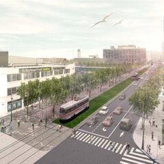
Toronto's prime waterfront thoroughfare is getting a $192-million facelift – with the goal to lure more people, tourists and small businesses to a long-neglected area of the city.

“We think Queens Quay Boulevard should be one of the top 10 streets in the world,†says John Campbell, CEO of Waterfront Toronto, which today unveiled its preferred option to transform the roadway between Spadina Avenue and Parliament Street by 2012.

Waterfront Toronto, set up by the city, the province and the federal government to revitalize the water's edge between Etobicoke and Scarborough, recommends a series of radical changes to create a “grand lakefront boulevard,†with streetcar lanes in the centre, traffic only on the north side and a new public realm with room for pedestrians and cyclists on the south side of Queens Quay.

In effect, the plan would reduce east-west car traffic to two lanes from four, with a lane of meter parking on the north side and, on the south side, a wide, tree-lined promenade for pedestrians and the Martin Goodman Trail for cyclists.

Mr. Campbell said his agency's preferred option is still subject to change, with input from the public (a meeting is set for tonight) in the weeks ahead. Council is expected to vote on the plan in July, with further approvals also required by the provincial government.

Toronto Mayor David Miller, a member of the board of Waterfront Toronto, said the Queens Quay proposal “will bring people down [to the water's edge] because it is beautiful, friendly for bicyclists and pedestrians.†An expected increase in pedestrian traffic to what could become a new tourism destination for the city “will create opportunities for businesses to succeed where in the past they have failed,†he said.

Tonight's public meeting by Waterfront Toronto is at the Westin Harbour Castle – Metro West starting at 6.30 p.m. For more details go to Waterfront Toronto's website, www.waterfrontoronto.ca
 
That's the first I've heard of the specific date and time (starts less than an hour from now!). Anyone going tonight?

They've announced it quite a few times / places already.

I really really hope someone manages to get down there.
 
Press release

http://www.waterfrontoronto.ca/dyna...84fe8a7c8648&fourth=49ca6fa011e8c&templatein=

49ca78cc6943e.jpg


49ca77464a4a1.jpg


49ca77822411c.jpg


49ca77ad52905.jpg


49ca77d2c3ca7.jpg


49ca77f49e6f9.jpg
 
from the backgrounder

Technically Recommended Alternative for Queens Quay

The technically recommended alternative for Queens Quay reduces the number of lanes of traffic on the street from four to two. This would provide two lanes of traffic on the north side with transit in the centre and an extended Martin Goodman Trail and pedestrian promenade on the south side. Within this recommended preferred alternative are two options — two-way traffic or one-way traffic along Queens Quay. While Waterfront Toronto has a slight preference for the two-way option at this time, further analysis and public input are required before a final option is presented to City Council.
The technically recommended alternative provides the greatest opportunity for a world-class waterfront street. Extensive traffic studies show that reducing traffic to two lanes along Queens Quay is feasible and that it will be able to accommodate current and future traffic demands. In addition, it allows for dedicated transit on the south side of the street with a continuous off-street Martin Goodman Trail to fill in the current gap in the Waterfront Trail along Lake Ontario.

This approach also allows for wider pedestrian boulevards (approximately six metres on the south side of the four-metre Martin Goodman Trail and three metres between the Martin Goodman Trail and the street car tracks). These pedestrian spaces feature a vastly enhanced landscape including a double row of trees along the waterside and an additional row of trees and sidewalk along the north side of Queens Quay. Currently, there is approximately two to three metres of sidewalk along the north and south sides of Queens Quay

Streetcar portal
Technically Recommended Alternative
The technically recommended alternative for the streetcar portal is Queens Quay between Freeland Street and Cooper Street. This option allows the existing portal on Queens Quay to serve streetcars traveling west while the new portal will serve streetcars traveling east. In this scenario streetcars turn east and west under the Queen Quay/Bay intersection separated from traffic and pedestrians.
The technically recommended alternative provides a better quality of transit service as a result of shorter delays at intersections and an overall shorter travel time.
There is no impact on roadway capacity and the portal fits within the right of way leaving room for public realm improvements.
 
"Mr. Glaisek referred to two rows of trees that will frame the pedestrian walkway as the “signature piece” of the redesign, which would satisfy city council’s goal to provide 35% of the street with canopy tree coverage.

“We’d actually produce this colonnade that pedestrians and cyclists would get to experience,” he said. “In general, we want to bring some beauty down here.”

Trees?!! Adding beauty!! We had to hire Europeans to tell us this?

I really wish Toronto understood how ugly its streetscape is without trees etc.

BTW, I love this design and hope for its speedy approval.
 
I hope they figure out a way to finally give the new trees enough water and nourishment to survive a couple years.
 
I attended. I like what they have planned, though it won't be until 2012 until we get to enjoy it, even though we had that sneak peek in 2006.

Here's what I wrote over at Spacing as a quick highlights. Hope the put up the display boards online soon.

• There are two recommendations going forward. Both will restrict Queen’s Quay to two traffic lanes, on the north side of the streetcar tracks; one will see westbound one-way traffic, the other will have bi-directional traffic.

• A four-metre wide Martin Goodman Trail, separated from the streetcar right-of-way with a row of trees, and complete the missing link in this important recreational and commuter route.

• A six-metre wide sidewalk along most of the south side, with additional tree plantings and the potential room for street stalls.

• Wider, fully accessible streetcar platforms. Stop locations will be realigned in places, but stop spacing will remain about the same, approximately 350 metres apart.

• The first phase of the Waterfront East Streetcar will run through the existing Bay Street Tunnel, to Queen’s Quay and emerge onto Queen’s Quay East between Yonge and Freeland Streets. The potential for a decorative portal entrance by the West 8/du Toit Allsopp Hillier design team has been identified. In the short term, a loop at Parliament and Queen’s Quay will be the eastern terminus of this new transit line, until connections are made with the planned Cherry Street streetcar route from King Street.

• There will be additional spots for bus loading and unloadings, as well as management of commercial deliveries to mitigate access and congestion issues for autos. There will also be limited on-street parking available. It is anticipated that the “level of service” for auto traffic on Queen’s Quay will be about the same, even with the obvious pedestrian, cyclist and transit priority measures.
 
Waterfront Toronto Unveils Technically Recommended Alternative for Revitalizing Queen

Don't know where else to post this:

Toronto, March 25, 2009 – After comprehensive study, Waterfront Toronto is recommending that remaking Queens Quay into a grand lakefront boulevard featuring streetcar lanes in the centre, traffic only on the north side and a pedestrian focused space on the south side is the recommended option for transforming the waterfront’s main road.

Waterfront Toronto will officially present the technically recommended alternative and two options for the traffic lanes, one which would have two-way traffic and the other one-way traffic, for public discussion and input tonight. While Waterfront Toronto has a slight preference for the two-way option at this time, further analysis and public input are required before a final option is presented to City Council.“Today we are one step closer to our goal of revitalizing Toronto’s central waterfront area,” said John Campbell, President and CEO of Waterfront Toronto. “From east to west, Queens Quay is the backbone of our waterfront and it will soon become a revered destination not only for Torontonians but the world.”

Transforming Queens Quay by creating a beautiful linear park on the south side of the street that would include a generous new pedestrian promenade and an expanded Martin Goodman Trail was part of the winning design for revitalizing the central waterfront selected by Waterfront Toronto in 2006 after an international design competition.

Prior to making any changes to Queens Quay, Waterfront Toronto and the City of Toronto began a Class Environmental Assessment (EA) process to study the feasibility, impact, and alternatives to the idea. In fact, Queens Quay has been subject to two EAs, one on the revitalization itself and another, done in conjunction with Toronto Transit Committee and the City of Toronto, focusing on planning transit services for the new waterfront development underway in East Bayfront and future communities in the West Don Lands and Port Lands.

The EA process, which has been ongoing for the past two years, has included the examination of several alternative planning solutions for Queens Quay. Each alternative presents a different configuration for a revitalized Queens Quay that has been analyzed and rated against a series of city planning and environmental criteria.

The EA process also includes a thorough and continuing public consultation component and extensive in-depth technical analysis.

Furthermore, rigorous traffic and transit modeling were undertaken to test the feasibility of all of the alternative design solutions.

Results of the EA show that the technically recommended alternative provides the greatest opportunity for creating a world-class waterfront street. Traffic analysis confirms that reducing traffic to two lanes on the north side of Queens Quay is not only feasible in the short term but can also accommodate future traffic demands.

The Class Environmental Assessment process is ongoing and public input is still being sought. The recommended plan incorporating the Preferred Alternative will be identified after we have taken into account public and stakeholder input. It will go to City Council for approval in July.

The revitalization of Queens Quay is budgeted at approximately $192 million which includes all new services and public realm improvements and $150 million for new transit along Queens Quay in the new East Bayfront area.

The first phase of construction from York to Spadina is expected to begin about one year after the completion of the EA. Waterfront Toronto’s goal is to finish construction along Queens Quay by 2012.

The Government of Canada, the Province of Ontario and the City of Toronto created Waterfront Toronto to oversee and lead the renewal of Toronto’s waterfront. Public accessibility, design excellence, sustainable development, economic development and fiscal sustainability are the key drivers of waterfront revitalization.

http://www.waterfrontoronto.ca/dyna...84fe8a7c8648&fourth=49ca6fa011e8c&templatein=
 

Back
Top