Toronto Ontario Line 3 | ?m | ?s | Metrolinx

I really don't think this is the case and we have two good counter cases in Toronto on Yonge and Bloor.

How the DRL interacts with existing surface transit is, of course, kind of ambiguous at this point for a number of reasons.

As a general principal the more a surface route overlaps with the DRL, and the extent to which a the DRL has BD-style spacing in that segment, the greater odds are of getting replaced.

Second, surface routes should be altered (within practicality) to integrate with the DRL rather than the other way around since they're inherently more flexible. For instance, maybe planners decide the DRL should follow King east of the CBD, but Queen west of the CBD. In that case the 501 and 504 could be merged into a kind of 'downtown' route which would travel along King West and Queen East, crossing up Church or something.

You mean something like this?:
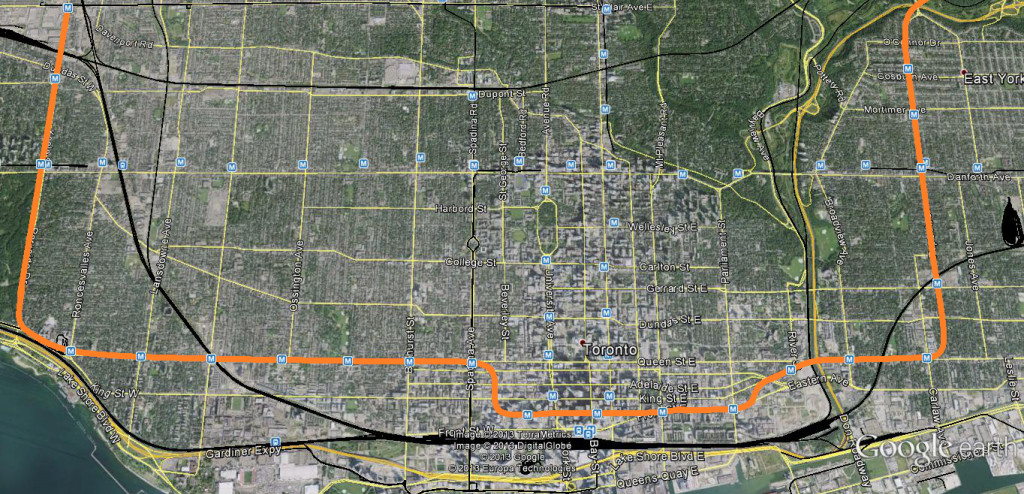


Per this alignment the 501 Queen could be permanently split into two parts, one starting from Roncesvalles heading west to Long Branch, the other starting from Charlotte Loop then up Spadina via Spadina-Queen Stn to Neville Park. The 504 King could continue as is from Dundas West down Roncesvalles and across King to Charlotte Loop, interlining with the 501 thereafter to carry onwards to Neville Park. Broadview would get it's own designated streetcar route number, possibly interlined with the new Cherry St streetcar to provide a true north-south anchor route in the east end, that or service south of Dundas Street on Broadview is eliminated.
 
This is DOWNTOWN Toronto we're talking about. Wherever the stations will be, it'll be UNDER the Yonge-University line. That means a longer trip just for using the steps, escalator, or elevators. Those steps and escalators will have to be angled, at best, and long. (The Wheaton station in Washington, D.C. has a 70 m or 230 feet escalator for a vertical of 35 m. It takes 2 minutes and 45 minutes to ride that.) The stairs might have flights of steps circling around an elevator shaft, but most likely they'll would be used only in an emergency. I'll take the streetcar for short trips in the area, if it takes too long to use escaltors (and if they're working).

461112546_47c193b296_b.jpg

WKL: That escalator at the Wheaton,MD station of WMATA's Red Line I believe is the longest in the Western Hemisphere and I believe
Forest Glen (or the Glenmont terminal) is one of the deepest stations in the W.H. and is served by public elevators only...

This is the type of construction that can make subways very costly and hopefully the TTC does not need to build stations that are this
deep on any future Subway extensions...

LI MIKE

The DRL will be under the utilities (sewers, water, electrical). The DRL will have to go UNDER the Yonge and University subways. The DRL will have to go UNDER the PATH tunnels. Will there be a mezzanine level above the DRL stations or will the access stairs/escalators/elevators go direct to DRL platform? It may or may not go very deep, but if they have go under the building foundations, they'll have to be deep enough so as to not undermine those foundations.
 
At least it doesn't have to snake around even more ancient utilities and long forgotten archeology and burial sites which is currently taking place with other tunneling projects with no complaints or chickening out.
 
Meanwhile, news from Washington, D.C., a $26 billion plan for Metro expansion

From this link:
Metro considers building ‘inner loop’ of new stations to ease congestion in system’s core

Metro is trying to find long-term solutions for alleviating congestion in its 37-year-old rail system, and the agency’s planning staff argues that adding longer cars or building various streetcar, light-rail and bus rapid transit systems that have been proposed for the region isn’t likely to be sufficient to solve the problem.

More stations and tunnels are needed, Metro officials argue. Not to reach new and different parts of the region, but to take the pressure off its most heavily used and crowded lines.

Even though the Silver Line isn’t expected to open until early next year, Metro’s biggest choke point is already in Rosslyn, where rush-hour commuters in both directions regularly see filled-to-the-brim train cars pass them by. Metro began raising the possibility of a new underground tunnel between Rosslyn and Georgetown nearly a year ago, part of $26 billion in overall improvements the agency has proposed.

Now Metro’s planners have begun suggesting that the region add 10 new stations and create four “super stations†by adding capacity and connections around the two Farragut Square stations, Union Station, the Capitol South station and the Pentagon station.

And from this link:
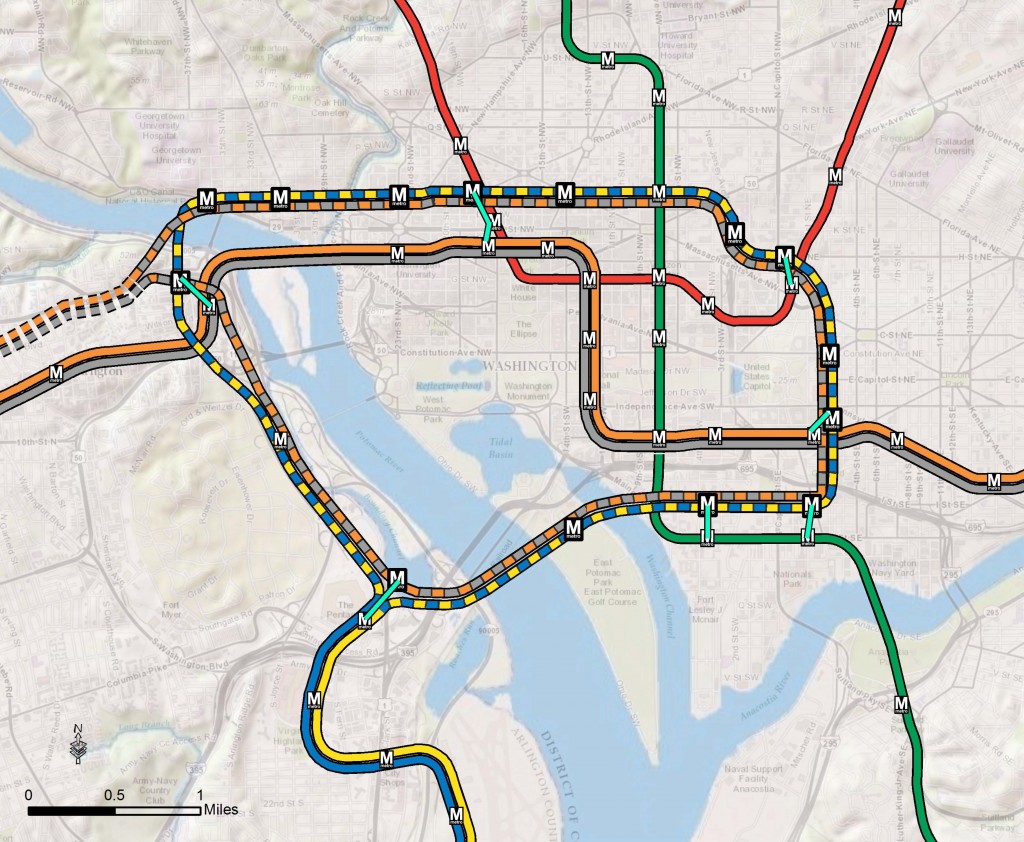
Step right up and check out the proposed 2040 core Metrorail configuration with new Blue and Yellow Lines and a third line in Virginia!

Large-Loop-1024x842.jpg


What does this network do? The proposed rail network shown above is expected to reduce future crowding on Metrorail, provide enough capacity for future development, and expand the reach of transit in the region, especially to regional activity centers.

Why are we proposing it? This rail network is part of the 2040 Regional Transit System Plan (RTSP). Its purpose is to develop the rail and surface transit network for 2040 that meets the needs of the growing Washington DC region.

What else have we considered? About a month ago, we posted about some of the possible long-range changes to the Metrorail core that we are considering as part of the RTSP. We analyzed four different core configurations, gathered your comments, and the final configuration for the core is shown above. As many of you commented, it is a combination of two of the scenarios (Scenarios B and C).

Next Steps: The next and final step for the RTSP is to use this configuration, along with the high capacity surface corridors, to conduct a final round of analysis. The output will provide us with information on ridership, mode share, levels of crowding, transfers, etc. and ultimately a final network for 2040.
 
I'm impressed with what Washington has build and continues to build in only 37 years. I've been on the orange line once and I thought it was pretty good. Too bad the same can't be said about the TTC.
 
Interesting that "alleviating pressure on existing lines" seems to be a theme in a lot of North American cities right now. Toronto wants the DRL to relieve Yonge-University-Spadina. NYC wants the Second Avenue Subway to relieve the Lexington line. Montreal wants to extend the Yellow Line to reduce pressure on Berri-UQAM. And now Washington wants a plethora of new Metro configurations to reduce congestion on the downtown part of their system.

Very interesting times indeed.
 
To provide extra coverage as well as relieve pressure is the way to go, if you're adding to the backbone part of the system. A secondary line can just be expected to add more coverage.
 
To provide extra coverage as well as relieve pressure is the way to go, if you're adding to the backbone part of the system. A secondary line can just be expected to add more coverage.

Very true. Providing a new suburban line isn't a bad thing, especially if it connects to the central area. It's when you add a bunch of feeder lines without expanding capacity further downstream that you start to get problems.
 

Back
Top