Toronto Lower Don Lands Redevelopment | ?m | ?s | Waterfront Toronto

Did something newsworthy happen along Commissioners today? A CityTV reporter was on the bridge this afternoon at 6 pm. I thought maybe I had missed something about the north plug being removed.

They just look for any excuse to park on the sidewalk
 
Did something newsworthy happen along Commissioners today? A CityTV reporter was on the bridge this afternoon at 6 pm. I thought maybe I had missed something about the north plug being removed.

You can see part of the north plug gone on Sunday that I shot.
They just look for any excuse to park on the sidewalk
They could had parked where the new Don Roadway connects to Commissioner or the close bike lanes at the east end of the bridge or a layover further to the west, but too lazy and thinking they are more important using the sidewalk.
 
Was curious in the aftermath of Beryl’s significant and widespread rainfall, how our new partially ‘unplugged’ river would look. First map is one reliable source for daily rainfall measurements. Significant 40 to 60 mm across the entire Don catchment basin seems to have had the (unsurprising) effect of raising water levels to perhaps the highest we’ve seen, and murky!

AAFDA22D-E777-43BF-A614-87676CE80608.jpeg


55974A73-8491-43DE-A301-3B163A4E1A38.jpeg


CB7211B3-0C5F-43EE-9514-75B56616A180.jpeg


E4B74DAB-A457-41B7-A80E-064683EA3862.jpeg


BECC6B4C-1F1F-4CC8-9F04-178217C773B0.jpeg


0AE85B52-C49F-402B-A676-29263A094594.jpeg


Digging continues on the south side of Lemon..

EC5015EF-E8AB-4033-8C39-2BFBB143A917.jpeg


13D241EE-3443-48CA-BA72-F317B7A9C9D2.jpeg


590A04D5-F0DA-42E0-9B15-5C3F3D54BB5D.jpeg


8CFED63A-BA98-4062-B1B2-67658EB86067.jpeg


BF7CF947-F736-4A04-ACDE-14B4CD055AE3.jpeg
 

Attachments

  • BB3281C1-84D0-4F75-A95C-DA4D019CBC0B.jpeg
    BB3281C1-84D0-4F75-A95C-DA4D019CBC0B.jpeg
    233.6 KB · Views: 23
Last edited:
Was curious in the aftermath of Beryl’s significant and widespread rainfall, how our new partially ‘unplugged’ river would look. First map is one reliable source for daily rainfall measurements. Significant 40 to 60 mm across the entire Don catchment basin seems to have had the (unsurprising) effect of raising water levels to perhaps the highest we’ve seen, and murky!
I too was very curious about this, thanks for taking a look!
 
Yes! This was a lot of rain in one day for Toronto, though obviously not the same impact as a real flash flood storm situation like in 2013 (I googled that to check the year, and we just missed the anniversary!).
The rain that fell was spread throughout the day, 2013 was a large intense dump. Definitely creates a different response and allows some of the vegetated areas to retain some of the water. It's still a significant response due to Toronto's urbanization and lack of stormwater quantity controls. Looks like a good monitoring opportunity for the floodways and overbanks!
 
I think in 2013, most of it fell in 1 or 2 hours. I remember the power went out at work so I went home. The roads were flooded (had to detour around a railway underpass), and sheets of water were shooting off the roof right over the gutters. Window wells for the basement were filled
 
I think in 2013, most of it fell in 1 or 2 hours. I remember the power went out at work so I went home. The roads were flooded (had to detour around a railway underpass), and sheets of water were shooting off the roof right over the gutters. Window wells for the basement were filled
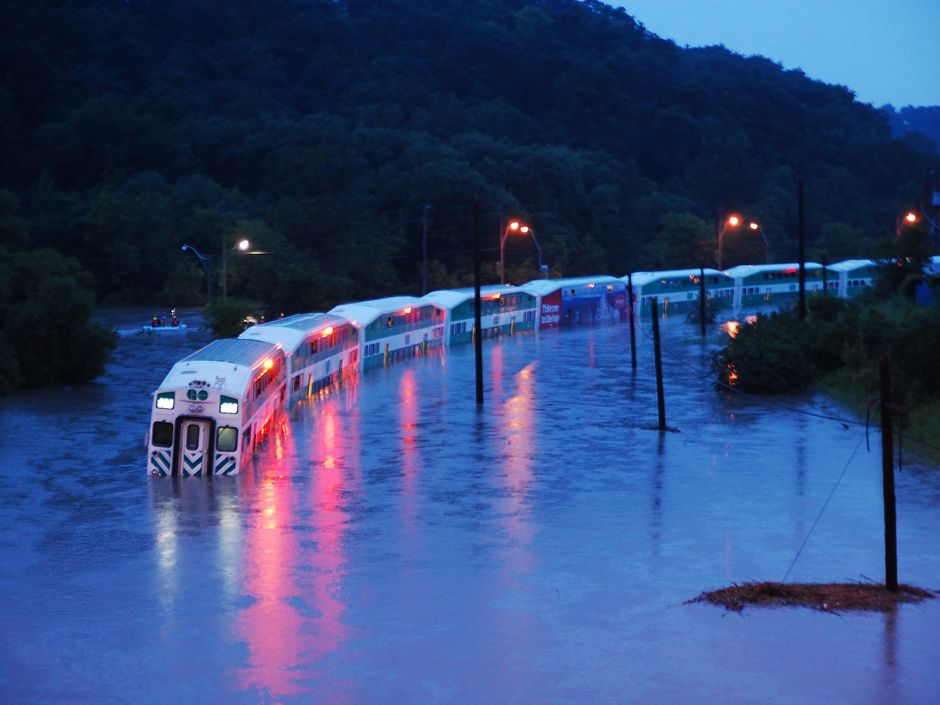
Yeah, I remember it pretty vividly. Someone gave me a lift home because of the deluge, and we saw Robarts get hit by lightning while stopped at the light at Harbord and St. George. My wife had to walk her bike up Spadina because the edge of the street was a complete river. One of my colleagues was actually on that Go Train that got flooded in the Don valley.

 
Taken 12 July. A few images for those unable to figure out IG 🤪 (Joking!) The new trees have really accentuated the roads! These streetscape will be great in a few years! Tons of cyclists/walkers today. They are doing a lot of work on the south side of Yellow. And the meadow plantings on the lrt median are looking like a meadow! The planters on the bridge are an anesthetic way to keep suburban drivers from trying to beat traffic to Rebel by using it. Again packed with cyclists and walkers.
IMG_5073.jpeg

IMG_5075.jpeg
IMG_5076.jpeg
IMG_5077.jpeg
IMG_5079.jpeg
IMG_5080.jpeg
IMG_5081.jpeg
IMG_5082.jpeg
IMG_5083.jpeg
IMG_5086.jpeg
IMG_5090.jpeg
IMG_5091.jpeg
IMG_5092.jpeg
 
Last edited:

Back
Top