Toronto Lower Don Lands Redevelopment | ?m | ?s | Waterfront Toronto

I hope there will be some eager photographers tracking the emergence of greenery into the new river area. Twenty five years from now it will be intriguing to compare the evolving ‘finished’ product.
I feel like without people occupying the place, there shouldn't be any privacy/spying issues with having a webcam setup. Does anyone do that anymore? I feel like we used to have a whole forum thread on 24/7 construction cams that was somewhat active. Wish they could set something up
 
Passed by the Port Lands on a Via train into Union this evening and saw some mobile crane parts (seemed to be luffing jib sections and y-guys) on flatbed trailers in a parking lot at the corner of Lake Shore and Cherry, anyone know if this is related to the current construction or maybe demo of the old Keating channel bridge?
 
Passed by the Port Lands on a Via train into Union this evening and saw some mobile crane parts (seemed to be luffing jib sections and y-guys) on flatbed trailers in a parking lot at the corner of Lake Shore and Cherry, anyone know if this is related to the current construction or maybe demo of the old Keating channel bridge?
They have been there for several weeks and that area has been used for general construction storage before. They look like crane sections and I doubt anything to do with Lower Don.
 
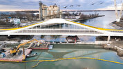
Old Cherry Bridge is going, going... but not gone.

Screenshot 2024-03-29 at 12.33.17 PM.jpg

Screenshot 2024-03-29 at 12.33.51 PM.jpg

Screenshot 2024-03-29 at 12.35.30 PM.jpg


Will be interesting to see how they redo this intersection now that it's no longer an intersection...
Screenshot 2024-03-29 at 12.35.41 PM.jpg
 
Wonder what's going here? Is it just going to be a big grassy hill?
Screenshot 2024-03-29 at 12.37.27 PM.jpg


Concrete forms for badlands look great.
Screenshot 2024-03-29 at 12.37.46 PM.jpg


Making good progress chewing through Villiers. And drum118's bridge shot.
Screenshot 2024-03-29 at 12.38.24 PM.jpg

Staging ground.
Screenshot 2024-03-29 at 12.38.57 PM.jpg


Old bridge. New Bridge.
Screenshot 2024-03-29 at 12.46.01 PM.jpg


Lower Don Lands from 120 meters up.
Screenshot 2024-03-29 at 12.39.11 PM.jpg
 
Last edited:
Old Cherry Bridge is going, going... but not gone.

View attachment 552099
View attachment 552100
View attachment 552101

Will be interesting to see how they redo this intersection now that it's no longer an intersection...View attachment 552102
They have done very little since I saw it a week ago and was expecting to see the bridge gone today. Most of the work has been removing the concrete on the southside of the bridge.

If one looks closely at the bottom left hand of the third photo from the top, it shows how much of the right-side break wall will have to be removed and a new one that will have to be built to line up the break wall on either side of the bridge. This will improve the flow of the channel a lot better.

As for the intersection, it will be removed along with the existing Lake Shore existing lanes when the new alignment is built as planned.
 
I heard that there's an infestation of more-than-usual swans this year. I did see them swimming at Sugar Beach a week or two ago, which is fairly rare. Is this something that's happening?
 

Back
Top