Toronto Lower Don Lands Redevelopment | ?m | ?s | Waterfront Toronto

This on City website may explain.

CHERRY ST From COMMISSIONERS ST To POLSON ST

Toronto-TMC: Road widening, asphalt paving and concrete work. 2 Northbound/Southbound lanes occupied.

Closure Type:Construction (Planned)
Time Frame:Continuous
From:Sep 21, 2020 at 00:01 a.m.
Until Dec 31, 2020 at 11:59 p.m.
Contractor:Sanscon Construction
Really glad to hear we're only losing that section of the Martin Goodman Trail for 3 months
 
  • Like
Reactions: DSC
Really glad to hear we're only losing that section of the Martin Goodman Trail for 3 months
I hope you are right, Cherry will be totally changed as the new bridges get built so I bet it will be a mess for FAR longer. It was really very dangerous today as the lanes are now very narrow and the trucks both frequent and fast!
 
I really wonder why they're widening a road that will be gone in the next couple years. But if they're widening it then the trail must be included in the plans. I will also be very disappointed if I'm wrong. I biked on the sidewalk on the east side today and there are a few pinch points that will only accomodate one person at a time due to trees.
 
I really wonder why they're widening a road that will be gone in the next couple years. But if they're widening it then the trail must be included in the plans. I will also be very disappointed if I'm wrong. I biked on the sidewalk on the east side today and there are a few pinch points that will only accomodate one person at a time due to trees.
I think they are really shifting the road over to the west so they can continue to excavate the new river. Then they will move it further so they can keep excavating. There will be a New Cherry Street (and the current Street will end at the new river) from next year and New Cherry will use the new bridges. The first of which arrives in October. Until then it will be a real mess.
 
Last edited:
With this development and Pine wood's etc. The movie production studios industries are really starting to flourish more than I ever thought it would .


Big steel bridges now floating towards Toronto’s waterfront

September 25, 2020

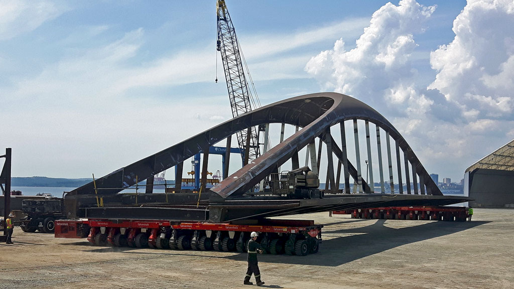
Four elegant steel bridges costing $100 million are sailing from Nova Scotia to Toronto’s waterfront redevelopment with the first expected to be set in place this fall.

The bridges are the first of up to seven eventually planned for the east Toronto waterfront area around Cherry Street where the Don River mouth diversion is well underway and moving towards the final phases of the $1.25 billion Port Lands Flood Protection Project.

Cherubini Group in Dartmouth is fabricating the four bridges and Troy Garnett, vice-president of sales and business development says the first unit, the 340-tonne, 57-metre-long, 21-metre-wide and 10.21-metre-high Cherry Street North transit bridge will be loaded onto a barge there and floated down the St. Lawrence into Lake Ontario and onto Toronto harbour in late October or early November.

”It’s going to be a spectacle and we’re going to get lots of drone shots of it coming in,” he says. “There’s lots of detail involved and we’re lucky to have been involved. We’re pretty excited.”

---------
“Cherubini Canada has a logistics team on board the ship and they will give us 24 hours advance notice as they clear Kingston coming from the St. Lawrence up to Lake Ontario,” says Karam. “They have SPMT (Self Propelled Modular Transfer) cranes on board and they will drop in place. That part will take a few days and then it will take up to three months to weld it in place.”

The second bridge will be the longer four-span Commissioners Street bridge weighing 1,210 tonnes, which comes in two sections to make up its 153 metre length with a 53 metre width and 10.16 metre height. The cantilever section was to arrive this fall but looks like it won’t make it before the Seaway closes for winter and it will mostly likely arrive in 2021.

In summer 2021 the third bridge, the three-span (20-70-20 metres) Cherry Street South unit at 790 tonnes, 111 metres long, 21 metres wide and 11.15 metres high will arrive and be installed.

In fall 2021 the twin mirror of the Cherry Street North transit bridge at 450 tonnes, the one for vehicular traffic, arrives for installation, according to the plan, he says, and that will go through the same installation process beside the transit component.

With those four bridges in place there are penciled in plans as transit demands increase for a second Commissioners Street bridge and second Cherry Street South bridge plus one more at Lake Shore Boulevard as a four span bridge, each section 24.4 metres and 37 metres wide, but there are no hard timelines.
1601037813479.png


1601037828868.png

1601037840728.png

1601037879424.png
 
Ties the "The One" steel for best news this month, wow!

But I was under the impression that Cherubini Group were doing its paint job too (maybe they'll be on-site here with paint brushes after installation/welding?).
 
Last edited:
I think they are really shifting the road over to the west so they can continue to excavate the new river. Then they will move it further so they can keep excavating. There will be a New Cherry Street (and the current Street will end at the new river) from next year and New Cherry will use the new bridges. The first of which arrives in October. Until then it will be a real mess.
I asked WT what was going on with the Martin Goodman, here is their response.

"The plan is to keep the Martin Goodman Trail open at all times, with the occasional temporary closure only when unavoidable.

In this case, we had anticipated using the west side sidewalk to create space for cyclists. However, unanticipated utility work created some physical barriers on that sidewalk. For the time being, the existing trail (on the east side of Cherry Street) has been reopened until the team can set up a temporary bike lane as a diversion. The pedestrian traffic will use the existing sidewalks either on the east or west sides depending on the construction activity."
 
Big steel bridges now floating towards Toronto’s waterfront

September 25, 2020

I answered my own question by actually reading the story. Despite the mis-leading headline, the first bridge won't be floating our way until late October or so. This pic is likely the bridge on its way to their paint-shop (also in Dartmouth).
 
I asked WT what was going on with the Martin Goodman, here is their response.

"The plan is to keep the Martin Goodman Trail open at all times, with the occasional temporary closure only when unavoidable.

In this case, we had anticipated using the west side sidewalk to create space for cyclists. However, unanticipated utility work created some physical barriers on that sidewalk. For the time being, the existing trail (on the east side of Cherry Street) has been reopened until the team can set up a temporary bike lane as a diversion. The pedestrian traffic will use the existing sidewalks either on the east or west sides depending on the construction activity."


Thanks a lot for looking into the matter :)
 
  • Like
Reactions: DSC
You know, everyone talks about The Well being a massive endeavor. Perhaps for residential purposes, it is. But still...it doesn't come with an entire island, parks and rivers as this does. So this is the far more bigger, complicated and breathtaking endeavor, IMO.

Furthermore, this also suggests something like the rail deck thingy is far more feasible than we think it is.
 
Last edited:
You know, everyone talks about The Well being a massive endeavor. Perhaps for residential purposes, it is. But still...it doesn't come with an entire island, parks and rivers as this does. So this is the far more bigger, complicated and breathtaking endeavor, IMO.

Furthermore, this also suggests something like the raildeck thingy is far more feasible than we think it is.


Agreed completely. Does anyone know the estimated cost of this devepment vs rail deck park?
 
Agreed completely. Does anyone know the estimated cost of this devepment vs rail deck park?
I don't know what the costs are personally. I'm pretty sure it will be public wallet burning expensive, to say the least. But I also suspect it's very much the same with this project.

...to my understanding, this was allowed to come fruition through the mutual arrangements and costs of the City, The Province and The Federal Government. During a time when all three where on much better relationship (and we had a much better Premier, IMO). So yes, when I say feasible...it's when governments co-operate. If they could get together on the rail deck, then who knows what might happen. Not sure I would go as far as to say sky's the limit, but would be in much better position to make it realized.

Unfortunately for the rail deck though, it's been gummed down with private interests mixing it up, to my understanding...so even with co-operation with all 3 levels of government, it might still not be possible at this time. But once that is sorted out, it could very well be possible. If that makes sense.
 
I suggest you need to keep in mid WHY the Lower Don Lands work is happening and why all 3 levels of government are funding it: it is being done to protect a large section of the City from flooding and open up more land for redevelopment (or development) - i.e. increase land values. The park (wonderful as it will be) is a subsidiary benefit. The rail-deck park (of which I am in favour) does not bring much (if any) redevelopment potential (though it would certainly make the area nicer to live/work in.)
 

Back
Top