News   Mar 28, 2024
 1K     2 
News   Mar 28, 2024
 562     2 
News   Mar 28, 2024
 851     0 

Road Safety & Vision Zero Plan

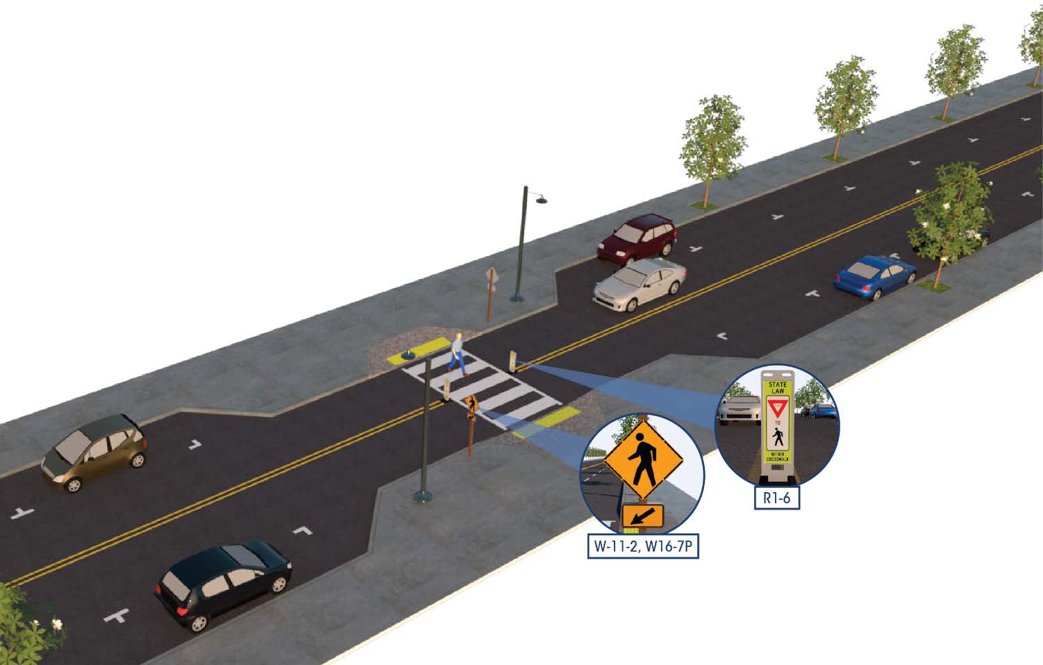
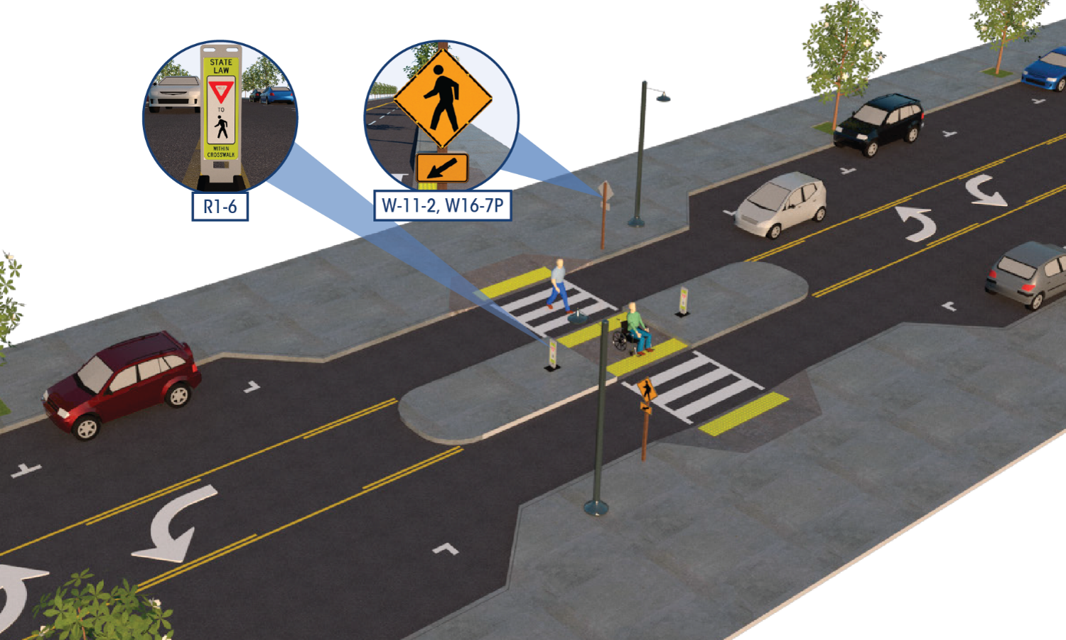
If people were able to walk to a store instead of driving, we would be safer. However, city zoning is preventing that. Without the neighbourhood corner store within walking distance, people have to drive to get that bag of milk or whatever.

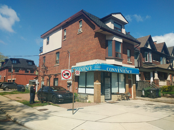
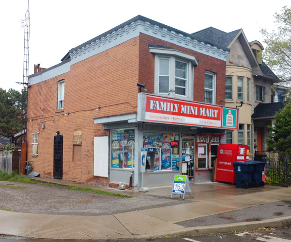
Spotting (and reviving?) the neighbourhood corner commercial building

From link.

Like so many people during the current pandemic lockdown, I’ve started to get to know my neighbourhood much more closely on daily walks for exercise from my home. One of the elements of Toronto’s everyday vernacular architecture I’ve always found interesting is the former corner shops embedded within residential neighbourhoods in the older parts of Toronto. Once upon a time these were the first stop for regular goods and sometimes services, not to mention local news and gossip, for nearby residents who could walk to them daily. But with the advent of widespread car ownership and supermarkets, many of them declined and were converted to become purely housing.

The need to address climate change and congestion, and more recently the sudden reorientation towards working from and shopping near home caused by the COVID-19 pandemic, have stimulated talk about reorienting our lives more closely around the neighbourhood we live in. Even before the pandemic, Paris mayor Anne Hidalgo had begun talking about the “15-minute city” where we can live, work, play, study, and shop all within a 15-minute walk. With the added experience of the pandemic forcing us to stick to our neighbourhoods, the idea of having more of our shopping, services, and workplaces near where we live has become all the more front-of-mind.

Current zoning, however, prohibits any use other than residential on streets within residential neighbourhoods, pushing all retail, service, and office uses to main streets. Corner stores that have maintained commercial use all along are grandfathered, but I’m told that once they are converted to residential use, they can’t go back. And, as we will see below, there are a fair number of these former commercial properties hidden within neighbourhoods in the older parts of the city.

Maybe one small nudge towards Toronto as a “15-minute city” could be to designate all of these former corner shops inside neighbourhoods as automatically, as-of-right, eligible to be reconverted to commercial uses. They probably would not become corner shops again — those still wouldn’t be viable in most cases. But they could be any other kind of commercial use too, whether retail, services, or offices – a barbershop, a lawyer’s office, a coffee shop or specialty store (or a coffee shop and specialty store), a co-working space, maybe even a startup. They also have the advantage of potentially being convenient live-work spaces, with living space on the upper floor; alternatively, the upper floor could supply a much-needed residential rental unit. It’s a change that would be relatively subtle, since it would only affect a tiny fraction of the buildings in a neighbourhood.

Ideally most employees and customers would be local and be able to walk or bike to these locations. But these buildings are generally also not far from transit. Once the pandemic ends, if driving is necessary, there will usually be parking spaces available on nearby streets during the day when some locals drive to their own work. Meanwhile, keeping people in or bringing people to the neighbourhood would provide additional business for local shops and restaurants, and bring additional “eyes on the street” to the area during the day.

Any reconversions would be a slow process, especially given how desirable housing is in the older parts of the city, so this would just be a very small step. But it might give a little nudge towards better integrating mixed uses into some older neighbourhoods without too much disruption.

In the meantime, my local walks have given me the opportunity to look for and observe these former corner stores more closely. Here are some of the indicators I’ve noticed for spotting former corner stores in residential areas. I’ve stuck to those inside neighbourhoods rather than ones on minor arterials like Pape Avenue, where they are less unexpected. These examples are all within a few kilometres radius of where I live, off the Danforth.

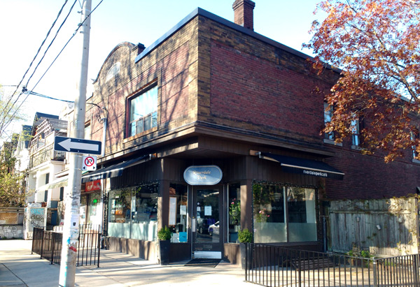
A few corner commercial buildings are still in use, of course. Some are still corner shops.

active-carlaw.jpg

active.jpg

riverdaleperk2.jpg


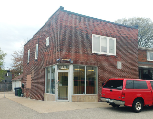
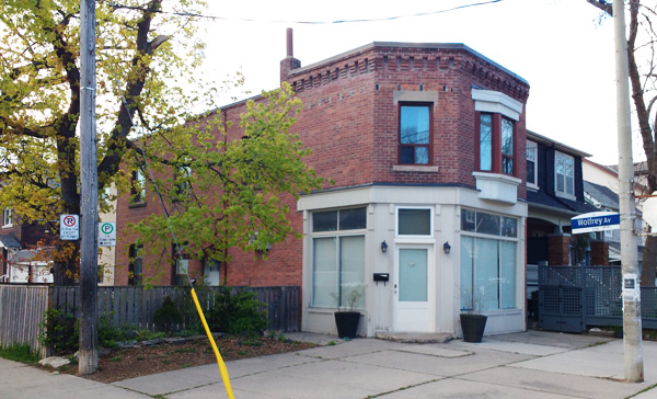
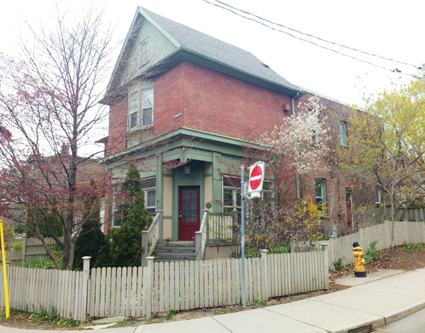
But there are many more that have been converted to residential over the years. Some have not changed much yet; others have long been absorbed into residential use and their former commercial identity is quite disguised.

One of the dead giveaways of a former corner store is the angled corner door.

office-eastyork.jpg

Wolfreyjpg.jpg

Carlaw-corner-door.jpg


Some streets that are apparently residential but designated by the City as collectors (PDF), such as Logan Avenue and Sammon Avenue, have these former stores on practically every block. On these streets, former corner shops often appear on two of the four corners of an intersection — perhaps they once offered different services.

But there are others hidden here and there on purely local streets, too. In these cases, they usually seem to be the only one on the intersection.

If anyone has further knowledge about or experience of these in-neighbourhood former and current commercial spaces, please share it in the comments.
 

A Reminder that Protected Bike Lanes Can Make Streets Safer for Everyone


From link.

As it moves forward with plans to build its first protected bike lane, Pasadena got a reminder from the Pasadena Complete Streets Coalition to hold a steady course. In the past, the city has watered down plans for robust bike infrastructure in response to complaints about traffic being slowed down.

Why is slowing traffic a bad thing? What a lot of street designers and engineers seem to ignore is that if they are not willing to design a street that slows traffic, they are essentially encouraging vehicles to go faster. It’s probably not their intended outcome, however, especially on residential streets.

Nevertheless, according to its website, “Pasadena is dedicated to creating a city where people can safely and comfortably get around by biking, walking, and riding transit.” It is currently “embarking upon the final design” for its first protected bike lane, on Union Street.

John Lloyd, writing for the Pasadena Complete Streets Coalition, has an important reminder for city leaders about why good design should be prioritized over concerns about slower car traffic: Protected bike lanes are safer for everyone using them, not just pedestrians and bicyclists.

A 2019 study spanning thirteen years in twelve cities found that protected bike lanes dramatically reduced fatalities for all road users on the streets that added them.

Writes Lloyd:

Fatalities fell by over 38 percent in Chicago, 40 percent in Denver, nearly 50 percent in San Francisco, 60 percent in Seattle, and a whopping 75 percent in Portland, OR. What these cities had in common were protected bike lanes. The researchers concluded that:
“…building safe facilities for cyclists is one of the biggest factors in road safety for everyone. Bicycling infrastructure — specifically, separated and protected bike lanes — leads to fewer fatalities and better road-safety outcomes for all road users.”

How did protected bike lanes make a difference?

The study found the main reason for this was the traffic calming effect protected bike lanes have on all road users. With protected bike lane street designs, traffic speeds are lowered, so when collisions do occur, they are far less likely to be fatal, and this protects everyone. Let’s face it, people make mistakes, but designing streets for slower speeds means fewer of those mistakes result in people dying.

It might be a good idea for advocates everywhere to keep this study handy, and show it to planners when they face arguments that robust bicycle infrastructure is unnecessary because “nobody bikes.” That is a circular argument anyway–but what should matter more are the safety outcomes for everybody.
 
I’ve been meaning to ask this question for a while but it always slips my mind until I’m waiting at a pedestrian signal.

Is there a reason why pedestrian signals are not automatically triggered on green? For example at an intersection, the east-west pedestrian signals are automatically triggered whether a pedestrian is there or not. But the north-south signals required a pedestrian to trigger them otherwise it remains no-walk.

https://sf.streetsblog.org/2021/01/...JzWLyFsn7fK_Hpf1KXMBFx1jE4pj7Hoc-TC2TZVbmMxlA

It’s an honest question which I’m curious about. Especially nowadays one would expect pedestrian signals to be automatically triggered.
 
^Lack of consistency in how beg buttons operate is a real problem.

Around here, what you describe is common where there is a stoplight where a less busy road crosses a main road. The green from the lesser road has minimal duration, only long enough to allow a couple cars to proceed, and without a Walk indication being provided - which is all that's needed most of the time. The green does not last long enough to allow a pedestrian to cross. The whole idea is to minimise delay to the busier street by not offering an opposing green for longer than absolutely necessary. The main street's green may not be interrupted until a car is actually detected waiting on the cross street.

Pressing the beg button triggers the yellow/red for the main street, and extends the duration of the side street's green for long enough to allow someone to cross the main street, with a Walk indication also appearing.

As a pedestrian, I like being able to push the button as (in theory) it guarantees one a safe crossing interval. But since no two beg buttons seem to work the same way, that assurance isn't always dependable.

- Paul
 
Seeing how Ontario and Toronto fails to innovate almost nothing on Vision Zero, we tend to copy MOSTLY what happens in the USA on the matter of road safety. Even then, when there is something "new" in the States, we tend NOT to implement them until years or decades after.

Here's an article on

Fix Our National Traffic Control Standards

that we not even look at.

From link.

Cross the street in an American (or Canadian) city, and few things will have a bigger impact on your chances of making it to the other side alive than the presence of a simple crosswalk, traffic light, or stop sign. The manual that sets the standard for such things is getting its first revision of the Vision Zero era — which could mean safer streets for pedestrians or simply better markings for robocars.

Following an outpouring from advocates across the country, the Federal Highway Administration recently announced that it will extend the deadline for public comment to May 15 on the next edition of the Manual of Uniform Traffic Control Devices, which sets federal standards for the signs, markings and signals that help instruct road users on how to safely move through our communities.

The MUTCD, as it is commonly known, is the document that professionals across the country look to when they make important decisions like how many seconds a crossing signal will give a pedestrian to cross the street (3.5 seconds for every foot of roadway, in the current edition), and exactly how the crosswalk she uses to do it should be painted.

But the manual hasn’t been revised since 2009 — before the advent of bikeshare, scooters, Vision Zero policies in dozens of U.S. cities., and, lest we forget, the rise of the autonomous car.
The 862 page tome (which will likely be a bit slimmer in the proposed next edition) doesn’t govern everything about the dangerous way we design our roads; the “traffic control devices” in its pages are pretty much limited to paint, signs, and lights, rather than more concrete physical barriers, like bollards and curbs. And engineers aren’t even legally required to follow most of the “standards” set out in its pages, unless the authors specifically note that engineers “shall” follow a particular recommendations to the letter.

Some advocates say that flexibility could be part of the problem.

“The MUTCD is not a sacred text, but it does get misused and abused,” said Don Kostelec, an Idaho-based planner who wrote a guide to the MUTCD for street safety advocates who want to get involved. “About three-quarters of it is ‘guidelines,’ not actual, binding standards — which means in the right hands, it gives [traffic engineers] a lot of flexibility to build some good things for walkers and cyclists, and in the wrong hands, it gives them an easy out to stay, ‘No.'”

But the bigger problem with the manual, Kostelec says, is that when it comes to protecting vulnerable road users, its standards aren’t always high — and that helps create a transportation culture where vehicle throughput comes before safety. The document, for instance, defines a “basic” crosswalk as a set of two parallel lines of paint on the ground, when most safety experts agree that designs that include flashing signals or high-visibility paint are more likely to grab a driver’s attention.

“Why don’t we default to the highest standard for safety, and let basic crosswalks be the exception?” Kostelec wonders. “Why do you need a justification to build a special hi-viz crosswalk? Change that, and the next [version of the MUTCD] could have a huge impact.”
Two-types-of-crosswalks.png

Why is a high-intensity activated crosswalk beacon (top) the exception, and two lines of paint on the ground (bottom) are the rule? Images: FHWA

Those low standards can be even more problematic when they get dragged into court. Even though the MUTCD isn’t legally binding, engineers can point to its standards to justify a dangerous road design — even though, as Kostelec aptly points out, “even an 800-plus page guide cannot account for every single roadway condition in the United States.”

“When we advocate for safer streets, the MUTCD may be cited by engineers as an obstacle for making the changes needed — sometimes correctly, sometimes incorrectly,” Eileen McCarthy, a retired attorney and member of Washington, DC’s Pedestrian Advisory Council, said in a recent article for Kostelec Planning’s blog. “As lay advocates we may not be able to understand every technical detail in the MUTCD, but we can develop a general working knowledge of it and use it for our own purposes and we can work with experts who are more adept with the technical details.”

Of course, the Federal Highway Administration probably isn’t revising the manual because it suddenly want bike and pedestrian advocates to have a say in how their roads are annotated. It’s more likely the FHWA is doing it in response to the rise of autonomous vehicles, which rely on regular road markings to navigate complex road environments — because paint on the ground is easier for a computer to recognize than something more complex, like a human on a bike.

Indeed, there’s an entire new chapter about AVs in the proposed revision of the MUTCD, and the possibility of robocars on our roads casts a shadow over much of the document. In its section about crosswalk guidelines, for instance, the FHWA specifically asks commenters to consider “the ability of machine vision of autonomous vehicles to detect accurately and react appropriately to the markings” when they make suggestions.

And in the section about bike lanes, it actually proposes “that bicycle facilities be segregated from other vehicle traffic using physical barriers where practicable and that road markings are needed to denote the end of a bike lane that is merged with traffic,” a recommendation it makes specifically “to accommodate machine vision better.”
Road-lines.jpg

For better or worse, AVs work best in environments with clear lane markings — and the MUTCD is being revised with robo-vision in mind. Image: CB Insights

That could be groundbreaking for cyclist safety nationwide — well, depending on your point of view. But whether it makes the final cut is up to the next FHWA administrator, and ultimately, DOT Secretary Pete Buttigieg himself.

In the meantime, advocates are urging their peers to roll up their sleeves, dive into the comments of the document, and make their voices heard.

“Most engineers are not going to stick their necks out for our ideals,” said Mike Wiltsie, program director for BikeUtah. “The best way we can bring about systemic change in our streets is to change manuals like the MUTCD to better reflect the world we want and provide the cover for engineers to make it reality. We have to show up and make our perspective known.”
 

EYES ON THE STREET: How Hoboken Has Eliminated Traffic Deaths

From link.

The mayor's attention to Vision Zero leads to years of no traffic deaths.​


Hoboken-biking-family.jpeg


Hoboken, a New Jersey city of about 54,000 souls directly across the Hudson from New York City, shows what can be accomplished when a municipality really focuses on the zero of Vision Zero — the “Mile Square City” has recorded no traffic fatalities for three straight years.

Mayor Ravi Bhalla kicked off the city’s Vision Zero program two years ago and got to work quickly. The city expanded its bike-lane network 38 percent in 2019 and 2020, so that its total on-street network of 16.3 miles is now nearly half (47.3 percent) of the city’s 33 miles of streets. (Most of those lanes are not protected, however: The 1.04 miles of protected lanes comprise 6.4 percent of the on-street bike network.)

By comparison, New York City, with more than 6,000 miles of road and a Vision Zero program since 2014, has managed to establish an on-street network of 1,375 miles, or about 23 percent of street miles, and expanded its network by about 6 percent from 2019 to 2020. (There are 546 miles of protected lanes, or about 40 percent of the New York City bike network.)

Bhalla’s attention to street safety has paid off. According to the municipality, from 2019 through 2020 there has been:

  • A 35-percent drop in the number of pedestrians struck by vehicles (to 35 from 54)
  • An 11-percent drop in the number of bicyclists struck by vehicles (to 31 from 35)
  • A 27-percent drop in the number of vehicle collisions (to 1,027 from 1,410)
“Hoboken is a pedestrian-oriented city,” Hoboken’s director of transportation and parking, Ryan Sharp, told Streetsblog. “There are so many ways that you can get around without driving, some people have stopped driving in Hoboken.”
Hoboken-crosswalks-paint-bollards.jpeg

A raised intersection at Ninth and Grand streets along with new crosswalk with wide stripes and reflective paint. Photo: City of Hoboken

The transformation of Hoboken is part of a larger movement toward bike-friendly policies in the cities across the Hudson from New York City, where young families, many of them priced out of New York’s expensive boroughs, have been making homes. Jersey City, next to Hoboken, in the last couple of years experimented with tactical urbanist solutions in furtherance its “bike master plan,” creating “pop up” protected bike lanes during annual cycling events. Jersey City, population about 260,000, also hosts an Oonee Pod, a secure bike-parking facility, at its Journal Square PATH station; meanwhile, New York City, population 8.7 million, has just one.

The locus of the Hoboken’s Vision Zero program is its main drag, Washington Street. Before being redesigned last year, Washington Street had a high number of collisions and an outmoded design, with no bike facilities, no curb extensions and traffic signaling that favored the fast movement of automobiles.

Hoboken-bikelane-1.jpeg

The protected bike lane on Newark Street. Photo: City of Hoboken

“Washington Street had great bones and a vibrant feel, but it badly needed a street re-design that matched its vibrant, historic character,” said Sharp, ticking of the measures that the city took, such as a curb extension at every intersection, bike lanes, retiming traffic signals so that pedestrians have a seven-second head start, and wide crosswalks with retro-reflective, thermo-plastic stripes.

The “road diet” that the municipality gave Washington Street via these measures decreased the room for cars in the roadway from 65 feet to 50 feet in some sections.

During the warmer months of 2020, every week from Thursday through Sunday, sections of Washington Street and other commercial areas became either open streets (where cars were banned) or slow streets (with reduced volume and speeds).

“Those interventions are forcing people to drive slowly through our commercial district,” Sharp said.

Per Sharp, Bhalla hasn’t slowed down during the pandemic, when many localities across the nation, not to mention the behemoth across the river, have been fairly paralyzed. Hoboken continued to install curb extensions and high-visibility crosswalks; 11 curb extensions in 2020, up from nine in 2019 (22-percent growth) and 150 high-visibility crosswalks, up from 40 (275-percent growth). New York City accomplished fewer curb extensions in 2020 over 2019 — 65 versus 102, or down more than a third in the same period.

Hoboken-bumpout-2.jpeg

A new bumpout at Garden Street and Fourth Street in Hoboken. Photo: City of Hoboken

Hoboken plans its Vision Zero projects to coincide with road repaving, in order to minimize extra costs and reduce the burden on taxpayers, Sharp said – so it’s not ripping up roads or painting bike lanes, for them all to get redone in the following year.

Bhalla aide Vijay Chaudhuri said that when the mayor, the father of two young children, ran for office, he made a commitment to making Hoboken a better and safer place for families to live. The Vision Zero program, Chaudhuri said, incentivizes families to stay in the city, rather than to move further out into New Jersey because they need a safe space to ride bikes with their kids.

Hoboken-bumpout-1.jpeg

At Newark Street and Willow, one intersection of improvements that was a part of the Newark Street safety plan. Photo: City of Hoboken

“It’s not just a quick trip from Hoboken to the suburbs,” Chaudhuri said of the city’s ability to keep families living happily within the city’s confines.

In Toronto, the suburban councillors (IE. Ford, Holyday, Grimes, Minnan-Wong) are doing their b̶e̶s̶t̶ worst to undo any Vision Zero initiatives.
 
Last edited:
That video is not yet listed--I'm guessing you're a patreon/member with early access?


It's a very good explanation of the problem with NA arterials that are bad at both jobs they are trying to perform. It also encapsulates what drives me crazy about our insistence of building density on these stroads. They should be left to be roads, and buildings should turn their backs to them. They will never be pleasant shopping streets--that is a foolish fantasy and just causes needless political tension in certain areas between locals/pedestrians/cyclists and people who need the road for through access. I'm looking at you, North York CC.
 

Safe Transportation for Every Pedestrian

From link.

On October 30th the NJDOT Bureau of Research hosted the Lunchtime Tech Talk! Event on “EDC-5 STEP: Safe Transportation for Every Pedestrian.” This event featured Peter Eun, a Transportation Safety Engineer with the Federal Highway Administration’s Resource Center’s Safety & Design Technical Service Team in Olympia, Washington. Mr. Eun discussed recent initiatives from FHWA regarding improvements in pedestrian safety and accessibility.

According to the National Highway Traffic Safety Administration, while 2018 featured a decline in overall fatalities on our roads, there was an increase of pedestrian fatalities, highlighting the increased need for action. Considering that over 72% of pedestrian fatalities occur at non-intersection locations, Mr. Eun focused much of his presentation on cost-effective countermeasures that can be systemically applied to reduce these crashes and save lives.

In his talk, he described how roadway configuration, traffic volumes, and posted speed limits inform the selection of appropriate countermeasures. By way of example, he referred to the Crosswalk Markings section of the Manual on Uniform Traffic Control Devices (MUTCD Section 3B.18):

“new marked crosswalks alone, without other measures designed to reduce traffic speeds, shorten crossing distances, enhance driver awareness of the crossing, and/or provide active warning of pedestrian presence, should not be installed across uncontrolled roadways where the speed limit exceeds 40 mph and /or either has 4 or more lanes without a raised median or island and ADT of 12,000 or more, or 4 or more lanes with raised median island and ADT of 15,000 or more”.

Setting the foundation for countermeasures, Mr. Eun cited grave statistics from research on how increasing speeds lead to greater serious injuries or fatalities for pedestrians and warned of a diminishing “cone of vision” at higher speeds as visual field and peripheral vision narrows. He shared a provocative safety video to convey how even small differences of speed can affect the ability of drivers to react and avoid crashes to the detriment of pedestrians.
Cosswalk-visibility-enhjancements.jpg

Crosswalk Visibility Enhancements

Describing them as the “Spectacular Seven”, Mr. Eun highlighted the following countermeasures:​
  • Rectangular rapid flashing beacons (RRFBs) are active (user-actuated) or passive (automated detection) amber LEDs that use an irregular flash pattern at mid-block or uncontrolled crossing locations. They significantly increase driver yielding behavior.
  • Leading pedestrian intervals (LPIs) at signalized intersections allow pedestrians to walk, usually 3 to 4 seconds, before vehicles get a green signal to turn left or right. The LPI increases visibility, reduces conflicts, and improves yielding.
  • Crosswalk visibility enhancements,such as crosswalk lighting and enhanced signage and markings, help drivers detect pedestrians–particularly at night.
  • Raised crosswalks can serve as a traffic calming measure and reduce vehicle speeds.
  • Pedestrian crossing/refuge islands allow pedestrians a safer place to stop at the midpoint of the roadway before crossing the remaining distance. This is particularly helpful for pedestrians with limited mobility.
  • Pedestrian hybrid beacons (PHBs) provide positive stop control for higher-speed, multilane roadways with high vehicular volumes. The PHB is an intermediate option between a flashing beacon and a full pedestrian signal.
  • Road Diets can reduce vehicle speeds and the number of lanes pedestrians cross, and they can create space to add new pedestrian facilities such as pedestrian crossing/refuge islands.
ped-refuge-islands.png

Pedestrian Refuge Islands

Using case examples from all over the country, Mr. Eun discussed several example situations where these countermeasures could be used, as well as the benefits to implementing them and the difficulties that may be encountered during implementation. Since expecting pedestrians to travel significantly out of their way to cross a roadway is unrealistic and counterproductive, improvements must be made to make crossings more accessible and more safe. By focusing on uncontrolled locations, agencies can address a significant national safety problem and improve quality of life for pedestrians of all ages and abilities.

Mr. Eun then addressed a systemic approach to identifying safety issues and appropriate STEP countermeasures. Using this systemic approach, agencies can focus on countermeasures that address risk rather than specific locations. Once a risk factor characteristic of a number of crashes has been identified, agencies can be proactive and address that risk wherever it appears within the system. A system-based approach acknowledges crashes alone are not always sufficient to determine what countermeasures to implement, particularly on low-volume local and rural roadways where crash densities are lower, and in many urban areas where there are conflicts between vehicles and vulnerable road users (pedestrians, bicyclists, and motorcyclists). As such, systemic safety analysis does not require extensive data or complex analysis methods to be effective, just the desire to make the biggest safety impact with limited resources.

 
I don't know why they put flexiposts in when the idea is to save pedestrians. If a car is driving through that flexipost, they should be stopped. That means a bollard.
 
I don't know why they put flexiposts in when the idea is to save pedestrians. If a car is driving through that flexipost, they should be stopped. That means a bollard.
It's my understanding, (I'm no expert) that in some cases they have to accommodate for the fact that there may be trucks or other vehicles that are larger than the lane that have to occasionally use the road. Theoretically it allows for a narrower lane for the majority of drivers, rather than having the hard infrastructure in place to accommodate the widest vehicles like busses and the occasional industrial truck. That being said proper bollards are probably able to be used more often than they are.
 

Back
Top