You are using an out of date browser. It may not display this or other websites correctly.
You should upgrade or use an alternative browser.
You should upgrade or use an alternative browser.
Redroom Studios
Senior Member
a bit too 'Vegas' for me!
ProjectEnd
Superstar
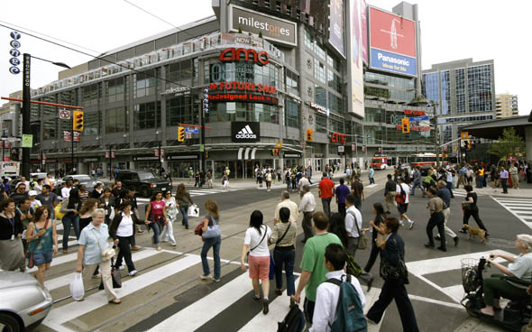
Gasp! People walking in the city? Where are the cars!? So 'behind!'
Marko
Active Member
Gasp! People walking in the city? Where are the cars!? So 'behind!'

'Behind' is an apt term considering that Brussels is about a thousand years older than Toronto.
It's not like that is the only street in Brussels either. It's probably the equivalent of Kensington Market or Yorkville - though even that's still a misleading comparison since many areas of Brussels existed hundreds of years before cars did - so of course they weren't considered when planning out city traffic patterns that consisted of either walking on foot or horse drawn carriage.
Here's another shot of the city you may like:

ProjectEnd
Superstar
/\ Taken from the Berlaymont if I'm not mistaken, and showing the eastern stretch (looking west) of the Wetstraat, or Rue de la Loi if you prefer the French.
While you are right to point out the differences in context, the Dexia building is hardly in 'Kensington' or 'Yorkville' territory since it is situated slightly south of the Bruxelles Nord rail station in the city center. I'm merely pointing out the fact that streets like Rue Neuve, where the video seems to have been taken from, are still plausible in such high-traffic areas. Bruxelles may be a thousand years older than Toronto, but it's not the thousand-year-old planning of this city that worries me, its the destructive way in which we are currently planning ours which is so troubling.
While you are right to point out the differences in context, the Dexia building is hardly in 'Kensington' or 'Yorkville' territory since it is situated slightly south of the Bruxelles Nord rail station in the city center. I'm merely pointing out the fact that streets like Rue Neuve, where the video seems to have been taken from, are still plausible in such high-traffic areas. Bruxelles may be a thousand years older than Toronto, but it's not the thousand-year-old planning of this city that worries me, its the destructive way in which we are currently planning ours which is so troubling.
Last edited:
Marko
Active Member
The picture may have been taken from Rue Neuve, but the Dexia building s blocks away in the background, much like The Hudson's Bay Building could be if a photo were taken from the right angle in Yorkville - that's all I was trying to say - 3 blocks in a different direction and it's likely a whole different streetscape that may not be any different from what we have here./\ Taken from the Berlaymont if I'm not mistaken, and showing the eastern stretch (looking west) of the Wetstraat, or Rue de la Loi if you prefer the French.
While you are right to point out the differences in context, the Dexia building is hardly in 'Kensington' or 'Yorkville' territory since it is situated slightly south of the Bruxelles Nord rail station in the city center. I'm merely pointing out the fact that streets like Rue Neuve, where the video seems to have been taken from, are still plausible in such high-traffic areas. Bruxelles may be a thousand years older than Toronto, but it's not the thousand-year-old planning of this city that worries me, its the destructive way in which we are currently planning ours which is so troubling.
We all like to look to Europe for examples of density living, but there's little to suggest they would have done things any different had the car had existed when much of the larger cities were in their growth stages. Photos like the one I posted are proof positive that the do in fact plan heavily around the car in newer areas where they have the opportunity to do so.
I'm from a European background myself and have seen much of this in person - and enjoying the differences greatly - but let's not fool ourselves into thinking they somehow knew better than we did when planning their cities.
Riverdale Rink Rat
Senior Member
Member Bio
- Joined
- Apr 29, 2008
- Messages
- 2,775
- Reaction score
- 273
- Location
- Back to East York... Alas!
LEED Gold and office space
http://www.theglobeandmail.com/real-estate/the-latest-in-cool/article1287423/
Quote:
"This year, downtown Toronto is being flooded with 3.14 million square feet of new office space as the finishing touches are put on the RBC Centre (1.2 million square feet), Bay Adelaide Centre (1.16 million square feet) and Telus Tower (780,000 square feet). Each tower is a showpiece of environmental design and energy efficiency and has been built to qualify for Leadership in Energy and Environmental Design Gold certification."
3.14Mn in new space -- that's a lot of new acreage! Assuming the old space gets absorbed (a big if in this economy, I know), downtown Toronto just got a lot bigger and busier.
Edward
Senior Member
Not really considering First Canadian Place is 2.7 million square feet by itself.
Marko
Active Member
Back to the building itself - and the LED lighting in specific - it looks like it's the same Color Kinetics floods inside the crown as were used around the observation deck of the CN Tower. The vertical fixtures, however, look like they're either custom made or something from a vendor I'm not familiar with.
Judging by the White dots in post #2182, it looks like specifically White LEDs and not an RGB product like the crown. There have been pictures of Blue light shown, so my guess is that it's a more simple Blue/White fixture and that only the crown can do the full RGB spectrum - or have people seen other colors going up the side accent bar also?
Judging by the White dots in post #2182, it looks like specifically White LEDs and not an RGB product like the crown. There have been pictures of Blue light shown, so my guess is that it's a more simple Blue/White fixture and that only the crown can do the full RGB spectrum - or have people seen other colors going up the side accent bar also?
3.14Mn in new space -- that's a lot of new acreage! Assuming the old space gets absorbed (a big if in this economy, I know), downtown Toronto just got a lot bigger and busier.
Not really considering First Canadian Place is 2.7 million square feet by itself.
...and First Canadian Place is negligible? These 3 new towers represent 16% more space than FCP contains.
42
Riverdale Rink Rat
Senior Member
Member Bio
- Joined
- Apr 29, 2008
- Messages
- 2,775
- Reaction score
- 273
- Location
- Back to East York... Alas!
A little under 5% new space in one whack.
http://www.avisonyoung.com/library/pdf/National/forecast2009.pdf
This report suggests there's 65mn sq ft in downtown Toronto. That makes the three new towers significant, IMO.
...and First Canadian Place is negligible? These 3 new towers represent 16% more space than FCP contains.
42
http://www.avisonyoung.com/library/pdf/National/forecast2009.pdf
This report suggests there's 65mn sq ft in downtown Toronto. That makes the three new towers significant, IMO.
Yup. Suddenly having 5% more space in a struggling economy is nothing to sneeze at. There is also new space opening at MLS soon too, plus 18 York after that. GO Transit will be moving into Union Station, effectively creating more space as well when they vacate their current offices, assuming the Avison Young report does not consider that space at Union as part of the inventory already - it's pretty degraded.
42
42
taal
Senior Member
It's a ton of space ... moreover, I wouldn't be surprised if most of it gets full within a year ... no, that's not good new (well depends who you are) because the older stock of inventory will struggle quite a bit until they undergo substantial retrofits ... and even then, it's probably going to take a while to absorb all the new (old vacated space)
taal
Senior Member
Interesting report (not sure of the source):
http://officesearchtoronto.com/?p=3389
Kind of the opposite of what I said though
http://officesearchtoronto.com/?p=3389
Kind of the opposite of what I said though
Dan416
Senior Member
Interesting report (not sure of the source):
http://officesearchtoronto.com/?p=3389
Kind of the opposite of what I said though
In that article they mention the "West End". Do they mean Mississauga? Etobicoke? Both?


