News   Apr 24, 2024
 357     0 
News   Apr 23, 2024
 2.7K     6 
News   Apr 23, 2024
 649     0 

Miscellany Toronto Photographs: Then and Now

Amazing, isn't it?......That it was once at the water's edge!
View attachment 137787
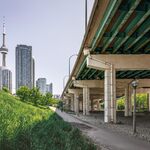
So many photos from the Toronto Archives were taken from the roof of the T.H.C. building. One day I would like to go up there and do a few then & now photos before they build the next building. It might be too late Goldie now that I think about what is already there. Has it ever been part of Doors Open ?
 
I shot these five years ago........wish I'd taken more.
Harbour Commission Bldg. view 1.jpg
Harbour Commission Bldg. view 2.jpg
Harbour Commission Bldg. view 3.jpg
Harbour Commission Bldg. view 4.jpg
Harbour Commission Bldg. view 5.jpg
Harbour Commission Bldg. view 6.jpg
 

Attachments

  • Harbour Commission Bldg. view 1.jpg
    Harbour Commission Bldg. view 1.jpg
    48.5 KB · Views: 589
  • Harbour Commission Bldg. view 2.jpg
    Harbour Commission Bldg. view 2.jpg
    35.9 KB · Views: 604
  • Harbour Commission Bldg. view 3.jpg
    Harbour Commission Bldg. view 3.jpg
    44.7 KB · Views: 605
  • Harbour Commission Bldg. view 4.jpg
    Harbour Commission Bldg. view 4.jpg
    47.9 KB · Views: 603
  • Harbour Commission Bldg. view 5.jpg
    Harbour Commission Bldg. view 5.jpg
    42.4 KB · Views: 617
  • Harbour Commission Bldg. view 6.jpg
    Harbour Commission Bldg. view 6.jpg
    42.5 KB · Views: 635
McCaul Street Loop.

Then (1975. I remembered the date when I looked at the picture but I lost track of where I found it.) and today, Sunday March 18, 2018.

In the Then picture, the patch of grass in the middle of the 'loop' is now today an OCAD building completely encircled by the streetcar track.

Above the loop today is the 'Village by the Grange' condo complex.

Be sure to visit the VBTG food court. A bustling place. Nothing like it in any condo in Toronto.


TTC_Peter_Witt_streetcar_in_1975.jpg


IMG_5009.JPG
 

Attachments

  • TTC_Peter_Witt_streetcar_in_1975.jpg
    TTC_Peter_Witt_streetcar_in_1975.jpg
    192.4 KB · Views: 653
  • IMG_5009.JPG
    IMG_5009.JPG
    199.9 KB · Views: 620
This "Then" image - 1928 from the Spadina Bridge, looking E.) needs a "Now" companion.
Panorama-composite-from Spadina Bridge 1928.jpg
 

Attachments

  • Panorama-composite-from Spadina Bridge 1928.jpg
    Panorama-composite-from Spadina Bridge 1928.jpg
    173.1 KB · Views: 625
The Google folks linked many Toronto Archive pics to a Google map and have an interactive thing going on here. Click on the blue dots to see the Then pic or pics. I clicked about 50 of the blue dots... 10 of them were 'just in the ballpark' of the actual location. They probably used artificial intelligence to compile this. A nice result.

https://oldtoronto.sidewalklabs.com/#
 
Last edited:
The Google folks linked many Toronto Archive pics to a Google map and have an interactive thing going on here. Click on the blue dots to see the Then pic or pics. I clicked about 50 of the blue dots... 10 of them were 'just in the ballpark' of the actual location. They probably used artificial intelligence to compile this. A nice result.

https://oldtoronto.sidewalklabs.com/#
Absolutely Amazing!! They also have an easy way to correct info, I saw two photos mis-identified and reported them.
 
i reported a couple dozen yesterday, in Leaside and East York, some egregiously off base

great project, i trust they will act on the corrections soon...
 
junction of King St. E. and Queen St. E. .....1911
That's one of the photos on the Sidewalk Labs site I corrected today - they had it at the intersection of Don Mills and Wynford Drive.o_O

Part of the problem is improper labelling of the Archives photos - but this one was labelled 'King Street - Queen Street (Intersection west from Don Bridge)'
 

Back
Top