

thecharioteer
Senior Member
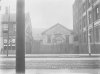
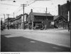
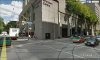
Richmond Street West, just east of York:
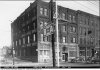
1913 (TPL) (Eaton's warehouse behind):

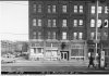
1953 (Osgoode Hall to left):


1960's:


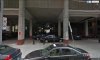
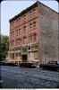
Today:

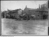
NE corner Richmond & York
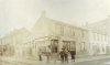
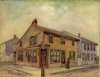
Crispin's Tavern (1880's?):

As painted by Owen Staples 1912:

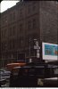
1909:

1922:

Today:

1913 (TPL) (Eaton's warehouse behind):
1953 (Osgoode Hall to left):
1960's:
Today:
NE corner Richmond & York
Crispin's Tavern (1880's?):
As painted by Owen Staples 1912:
1909:
1922:
Today:
Attachments
-
 richmondstreetchurch1913.jpg90.3 KB · Views: 1,186
 -
 130richmond1953b.jpg99.6 KB · Views: 1,220
 -
 130richmondwest1953a.jpg98.4 KB · Views: 1,206
 -
 130richmond1960s.jpg96.9 KB · Views: 1,216
 -
 130richmondwestgoogle.jpg92.8 KB · Views: 1,133
 -
 richmondyork1909.jpg93.5 KB · Views: 1,229
 -
 richmondyorkgoogle.jpg100.8 KB · Views: 1,129
 -
 richmondyork1909a.jpg94.9 KB · Views: 1,230
 -
 crispin'stavern.jpg94.3 KB · Views: 1,205
 -
 crispinsstaples.jpg97.5 KB · Views: 1,147
 -
 richmondyork2.jpg102.1 KB · Views: 1,185


Last edited:


