News   Jan 10, 2025
 319     0 
News   Jan 10, 2025
 252     0 
News   Jan 09, 2025
 2.3K     4 

Miscellany Toronto Photographs: Then and Now

Overlooking Riverdale Park

A "Now" would be interesting, if the location could be ascertained.

Yes, I'd like to see a "Now."
The location is indicated here (thumbnail) - "X" marks the spot.
This is obviously high land overlooking the valley.
This spot was once open parkland - it's now behind a high school.
 

Attachments

  • Riverdale Park Drumhead map.jpg
    Riverdale Park Drumhead map.jpg
    85.2 KB · Views: 373
Yes, I'd like to see a "Now."
The location is indicated here (thumbnail) - "X" marks the spot.
This is obviously high land overlooking the valley.
This spot was once open parkland - it's now behind a high school.

What direction are we looking toward in the Drumhead photo, Goldie?
Riverdale Park was the place for showing royal visitors off to the school children of Toronto. There is bound to be a picture in the archives close to the 1939 one of the King & Queen at City Hall--as well as the one I was at in 1950 during the visit of Princess Elizabeth and the Duke of Edinburgh.

The park was roped off in a series of w-type bends with sufficient room for the official cars to drive on a grass track in between. The car went by at such a pace that if you weren't in the front row you missed it. A bit of a waste of a Saturday afternoon, really.
 
Yes, I'd like to see a "Now." This spot was once open parkland - it's now behind a high school.

The view is of the running track between the Riverdale Hospital (now Bridgepoint Health) and the City Adult Learning Centre at 1 Danforth. There's a rather scary pedestrian walkway leading from the north end of the track over the DVP on ramp and through the school's grounds to Danforth.
 
The Vimy Ridge connection? - Royal Visit?

What direction are we looking toward in the Drumhead photo, Goldie?
Riverdale Park was the place for showing royal visitors off to the school children of Toronto.

I believe we're looking directly south from the hill overlooking the valley parkland.
I'm beginning to wonder if this event was the Royal visit of 1939?
The other photo (from the valley floor) is looking towards the hill along Broadview where there appears to be a replica of the Vimy Ridge War Menorial.
Does anyone know the date 0f this, obviously popular, event?
 

Attachments

  • Riverdale Park Drumhead Service c.1936.jpg
    Riverdale Park Drumhead Service c.1936.jpg
    95 KB · Views: 337
An interesting side-note to this visit (given the current interest in Edward's brother George, as portrayed in "The King's Speech"), is that George, the Duke of Kent, accompanied Edward on this visit to Toronto, resulting in the naming of the gates for both "princes".

I always thought they were called the "Princess Gates", and I definitely had no idea they were named after that white supremacist and Nazi sympathizer, Edward. Now I'm going to feel slightly ill whenever I pass by the gates.
 
" I definitely had no idea they were named after that white supremacist and Nazi sympathizer, Edward." QUOTE Science&Motion.


No problem; just keep thinking of his brothers.

Regards,
J T
 
Finally, the end!

It's taken me something like 10 days to read through this entire thread, but worth every minute.

Guess I should introduce meself.

Toronto born (end of the 1970s) & bred, grew up in the Yonge & Sheppard area. Went to McMaster for my undergrad, which is where my avatar comes from, and yes, I run this website:

http://hamiltontransithistory.host-ed.net/index.html

Now I'm living in the Main & Danforth area.

I'll be resurrecting some old posts to comment on them, but before I do I want to show something from my current neighbourhood

The SW corner of Main & Danforth.

Now a Hakim Optical, but originally a branch of the Home Bank of Canada. It's carved into the stonework at the top

Since the neighbourhood didn't develop until WWI or shortly after, I wonder if this was one of the last branches of this bank built. The Home Bank collapsed in 1923.
 
That "Elevation Benchnark" photo is certainly interesting.
Perhaps someone can give us an explanation of the content and purpose of these plaques.

Gladly

This is a reference point for surveyors and engineers, allowing them to determine heights in the area.
BM - Bench Mark
No (80)76 - the serial number for this particular bench mark. Notice that it was originally just numbered 76, it was renumbered and the extra digits were stamped later
ELE 381.30 - ELEvation above sea level, 381.30 ft
 
September 30 addition.


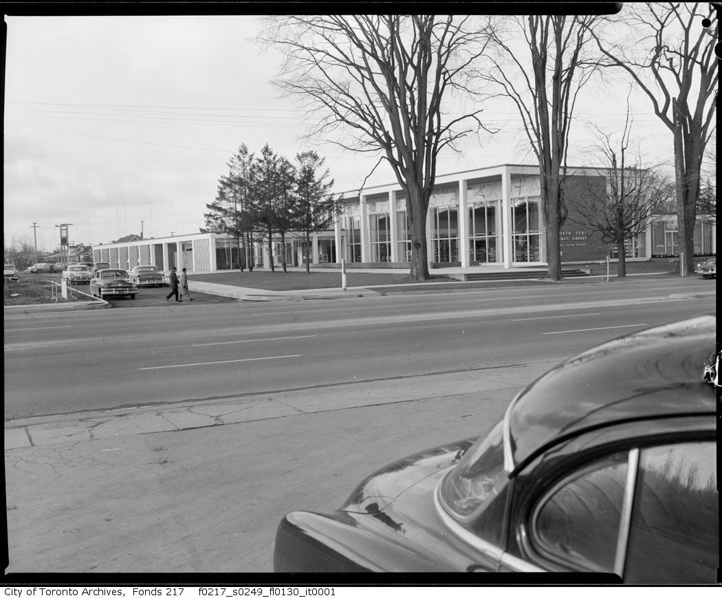
Then. 5126 Yonge, Gladys Allison branch, North York Library. Posing for its civic photograph in 1959, I suppose, the year it was built. Demolished in 1985.

5126yongeGladysAllisonbldg.jpg


Growing up in the Yonge/Sheppard area, this was my library branch (this and the small library branch in the Sheppard centre)

IIRC, the single story wing on the left was the children's section, where I'd find Tintin books galore. To a 4 year old, the place was huge.

Above the tall windows are a series of what look like letters, there's a stylized 'A' and what I'd call a greek psi. These panels were salvaged when the library was demolished, and are now in the Atrium of the North York Central Library, above the doors leading into the adjoining mall. (These 'letters' bugged me as a 4 year old in kindergarten, cause I couldn't figure out what they spelled;) )
 
Last edited:
fo0217_ser0249_f0217_s0249_fl0083_i.jpg


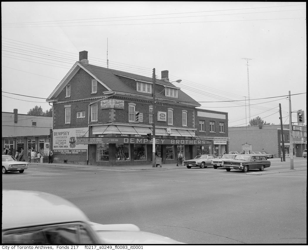
Dempsey Brothers Hardware was a great place. Smelled like old wood, and they had EVERYTHING. If I dig around in my parents garage even today I'll probably find something with a Dempsey price sticker on it. I still have a small claw hammer that I bought with my allowance years ago.

If you want a similar experence, vist Tracy Hardware on Danforth, west of Main
 
February 3 addition.

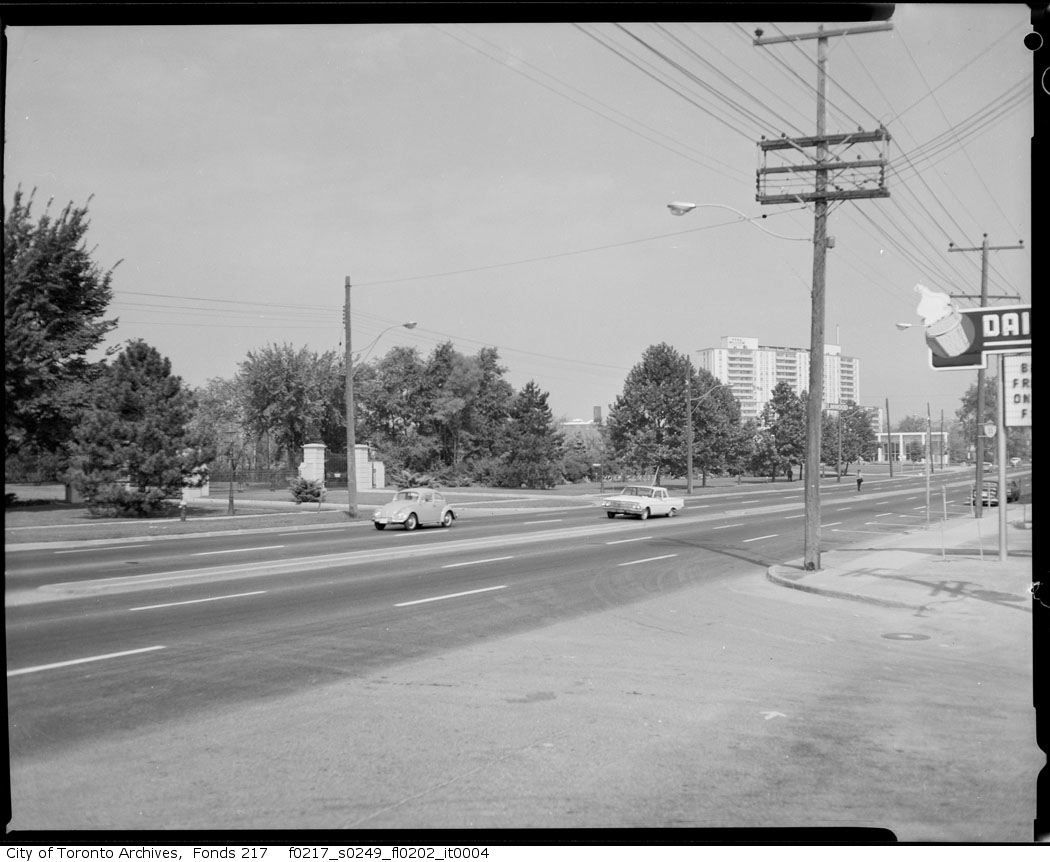
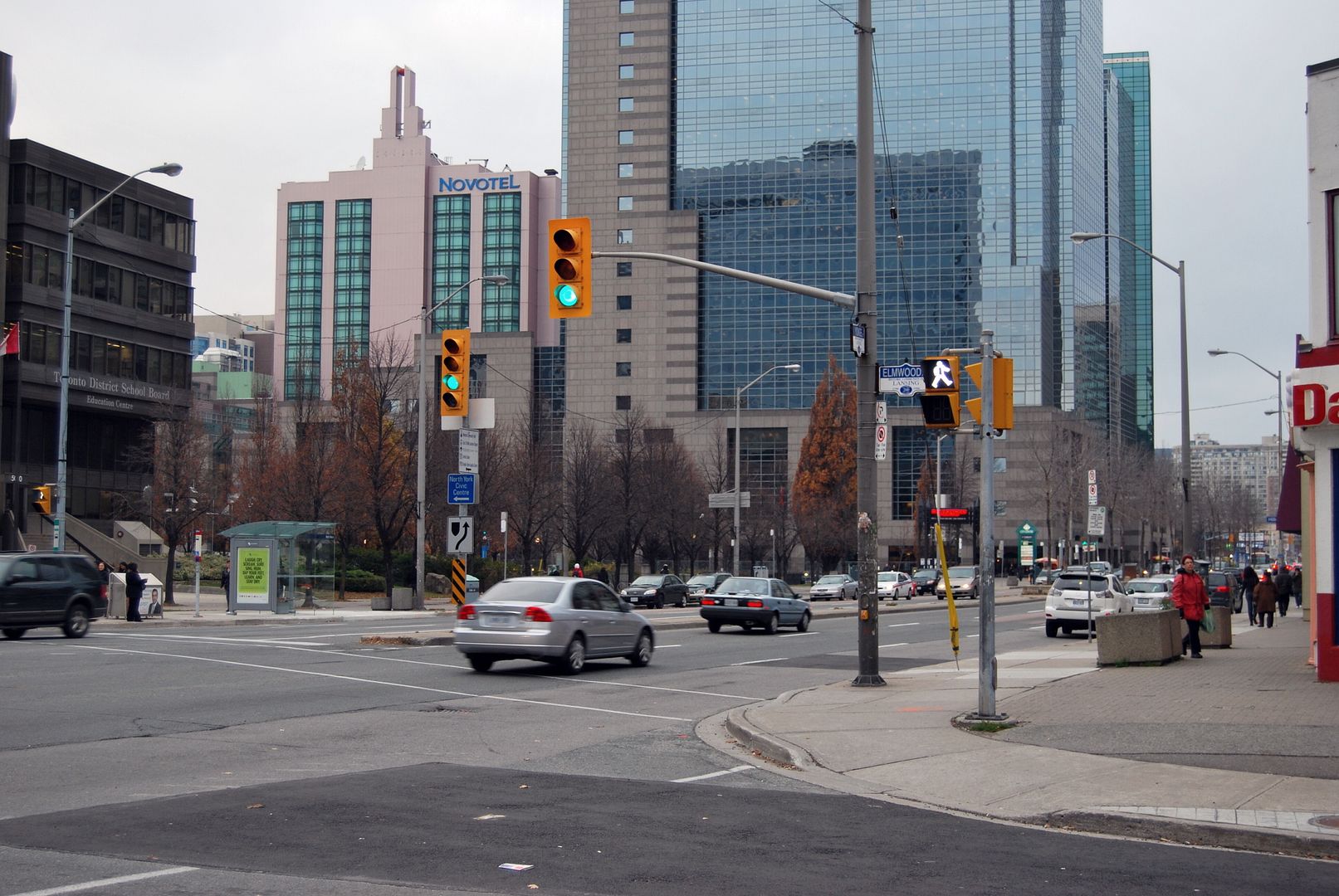
Yonge and Elmwood in North York, looking NW.

Then: 1960s?.

fo0217_ser0249_f0217_s0249_fl0202_i.jpg


Now: November 2009. The Dairy Queen is still there.

CSC_0035-1.jpg

You're spot on about the Cemetery having once gone all the way to Yonge, as seen in this aerial photo. I think I read somewhere once that the long narrow shape of the cemetery is due to the fact that it used to be an airstrip.

Up until the mid-late 90s there was a public greenhouse at the cemetery. My mom and I would visit it in the winter months, it was cool going from -20 C and snow, to +20 C and lemon trees and cacti.
 
What direction are we looking toward in the Drumhead photo, Goldie?
Riverdale Park was the place for showing royal visitors off to the school children of Toronto. There is bound to be a picture in the archives close to the 1939 one of the King & Queen at City Hall--as well as the one I was at in 1950 during the visit of Princess Elizabeth and the Duke of Edinburgh.

The park was roped off in a series of w-type bends with sufficient room for the official cars to drive on a grass track in between. The car went by at such a pace that if you weren't in the front row you missed it. A bit of a waste of a Saturday afternoon, really.

Their Hignesses visited T.O. in 1973 and came down Avenue Road in an open car doing about 40km/hr. They waved, we smiled and waved back in time honoured loyal subjects fashion, everyone went home. :)

In 1971 Lord Mountbatten visited us Sea Cadets at HMCS York (this is the low building to the west of the Tip Top Tailor condos on Lakeshore). He was very kind and gave a nice talk. He certainly had a - shall we say - interesting war record.
 
I always thought they were called the "Princess Gates", and I definitely had no idea they were named after that white supremacist and Nazi sympathizer, Edward. Now I'm going to feel slightly ill whenever I pass by the gates.

I went to see "The Kings Speech". Edward and his wife Wallis Simpson are not at all in the least sympathetically treated in this film.
 

Back
Top