|
|
|


You are using an out of date browser. It may not display this or other websites correctly.
You should upgrade or use an alternative browser.
You should upgrade or use an alternative browser.
Evocative Images of Lost Toronto
- Thread starter LowPolygon
- Start date
steveintoronto
Superstar
Those pics tell a number of stories, not least to our prime discussion, what happened to the stadium and associated complex?The stadium we located was finally gone by the time the DVP on-ramp (Royal Dr.) was completed in 1961
I have a theory: Look closely at the 61 pic, and the concrete caissons and steel superstructure of the last span eastern end of the viaduct. They're gone. The DVP must have necessitated a re-build/extension of the eastern end of that viaduct structure, and the alignment for the DVP that mandated that also sliced off the western face of the promontory the sports facilities were on. I'm appalled on one hand, but question whether I have moral right to be. It is/was 'progress'...and so much has been lost due to it. Feelings aside, could it be that the Monarch Park Stadium and the new playing fields for the then Castle Frank High School (now Rosedale Heights School for the Arts) were a replacement for what was lost @ Danforth and Broadview?
I see that even that is now abandoned and full of construction equipment...
There's a story somewhere on this that we'll find. I'm a bit taken aback on what was necessary to accommodate the DVP under the Viaduct, most if not all of the bridges south of there were able to facilitate the RoW needed.
Btw: I deduced why The Danforth had four streetcar tracks in sections:
They must have been a by-pass to allow the original tracks to be rebuilt.
Further interesting clue as to the changing land-form around the Viaduct:
All pics public domain, but sourced from http://www.blogto.com/city/2012/11/what_danforth_avenue_used_to_look_like_in_toronto/
So was "Royal Drive/Winchester Drive" a "naturally occurring" ravine after all? How much earth was moved to facilitate building the Viaduct? And did "Royal Drive" get the name from the Royal visit held on Riverdale Flats?
Edit to Add: It seems likely that this is the remnants of the Winchester St/Drive underpass under the CP Rail tracks :

https://lowerdontrail.wordpress.com/
Attachments


Last edited:
44 North
Senior Member
Edit to Add: Found reference to "Viaduct Stadium" but not the same one:
http://www.blogto.com/city/2012/11/that_time_when_toronto_went_stadium_crazy/
I too stumbled on that article. Was not aware our search for large stadium sites was so broad. Stadiums in Rosedale, Riverdale East, the Don floodplain? Interesting stuff.
Those pics tell a number of stories, not least to our prime discussion, what happened to the stadium and associated complex?
I have a theory: Look closely at the 61 pic, and the concrete caissons and steel superstructure of the last span eastern end of the viaduct. They're gone. The DVP must have necessitated a re-build/extension of the eastern end of that viaduct structure, and the alignment for the DVP that mandated that also sliced off the western face of the promontory the sports facilities were on. I'm appalled on one hand, but question whether I have moral right to be. It is/was 'progress'...and so much has been lost due to it. Feelings aside, could it be that the Monarch Park Stadium and the new playing fields for the then Castle Frank High School (now Rosedale Heights School for the Arts) were a replacement for what was lost @ Danforth and Broadview?
That '61 photo is less oblique so doesn't show the under structures. The eastern end of the Viaduct wasn't torn down and still exists today as the '59 photo. Tho the tearing down of the stadium probably had something to do with the DVP. Bayview extension also required sizable land shifts. I believe there was a geographic feature just north of Bloor called Sugarloaf Hill that was obliterated.
Further interesting clue as to the changing land-form around the Viaduct:
All pics public domain, but sourced from http://www.blogto.com/city/2012/11/what_danforth_avenue_used_to_look_like_in_toronto/
This is showing Bloor just east of Sherbourne. You can see the still existing bank at the NW corner in the background. Definitely sizable earth-moving going on, related to extending Bloor further east, pushing the valley wall further north to accommodate it, and building the Rosedale bridge+Viaduct. Interesting story behind the Viaduct+Rosedale Bridge plans and how they morphed. Originally they wanted to keep Bloor straight in this section so it'd be a perfect line across the city, and use a T-shaped bridge at Parliament. A laudable goal. Believe the City even expropriated the land in Rosedale to make it happen, but Rosedalians prevented it. The current southward dip proved too tight for a subway in the underside of Rosedale bridge, hence why we have a newer concrete arch bridge for the subway (which they should really bring back the skylights for...ppl don't even know it exists).
So was "Royal Drive/Winchester Drive" a "naturally occurring" ravine after all? How much earth was moved to facilitate building the Viaduct? And did "Royal Drive" get the name from the Royal visit held on Riverdale Flats?
Edit to Add: It seems likely that this is the remnants of the Winchester St/Drive underpass under the CP Rail tracks :
Contractors have been able to incorporate old foundation stones unexpectedly found at the Belleville Underpass site into the new earthworks shoring up the tunnel
https://lowerdontrail.wordpress.com/
Ah, I remember seeing "Royal Drive" on a map somewhere. It was definitely coined from the '51 visit, and was very short-lived. I'm inclined to believe the old Don Mills rd / current DVP onramp is an old ravine. It showed up as such on an old map, and would make sense as a settler path of least resistance. And that's interesting to hear the old foundations will be incorporated into the Belleville Underpass. Goddam that project took way too long. Promised "three weeks" f'ing one year ago.
adma
Superstar
Further interesting clue as to the changing land-form around the Viaduct:
View attachment 117307
All pics public domain, but sourced from http://www.blogto.com/city/2012/11/what_danforth_avenue_used_to_look_like_in_toronto/
That photo's actually Bloor looking W to Sherbourne--you can tell by the still-extant bank.
Keep in mind that the "Viaduct" project referred, in the 1910's, to the entirety of Bloor-Danforth from Sherbourne to Broadview.
steveintoronto
Superstar
Just digging to see if I can find something extensive on the building of the "Bloor-Danforth Viaduct" and tripped across this:
I question the claim that it was intended for "tube" let alone a North Am gauge subway. I'd read previously (and the loading size bears this out) it was for a pending CPR plan to run a passenger line across East York and Scarborough. I'll search for clarity on that point, albeit the sharp curves stymied (so the story goes) doing that for subway.
Still digging on a number of facets, but in review of the rail-path underpass on the Belleville Sub...and I can't see how it could be any other underpass except for the Winchester one with cut stone that large...how much of an historical review was done before digging there? I'm now realizing in retrospect that I've been looking at the old Winchester bridge abutments every time I've crossed on the rail bridge to get past the construction site. I'm also now aware that the Riverdale Zoo uses the old Winchester alignment as their main thoroughfare.
- Mike Filey http://www.torontosun.com/2016/01/16/this-bridge-was-built-to-last[...]
Seems that one of the concerns many people had, that is the actual alignment of the viaduct had been thoroughly thought out. From the corner of Bloor and Sherbourne the connection would be deflected in a southeasterly direction and built on a 1,564 foot-long earth-fill causeway as far as the top of Parliament St. From there it would head northeasterly across the Rosedale Ravine on a 1,484 foot-long bridge to the vicinity of Castle Frank Cres. Here it would head due east a distance of 2,219 feet to the corner of Broadview and Danforth (exactly 13 feet short of a full mile). And in rejecting the concrete industry’s suggestion that the entire viaduct be built using only concrete, the city decided the project would be comprised of concrete piers with steel arches, with most of the steel coming from factories in Lackawana, New York.
The entire thoroughfare would be 86 feet wide and illuminated with street lights on poles down the centre of the right-of-way (long removed for safety reasons). That width was to cause problems in the old city since Bloor St. had been laid out with a 66 foot width, normal in the city’s early years. Following the opening of the Viaduct the city embarked on many major and costly sequential widenings of sections of Bloor St. west of Sherbourne St. [...]
- Mike Filey http://www.torontosun.com/2015/01/17/the-bloor-st-viaduct[...]
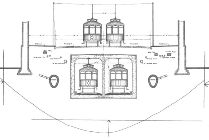
An interesting feature of Toronto’s new $2.5 million bridge was something suggested by Controller (later Mayor) Horatio Hocken in November of 1909. He suggested that even though it wasn’t yet approved whenever the bridge was built it would be prudent to include in the design to permit “tube” trains serving east Toronto to run under the bridge. Today that “provision” is used by subway trains on Line 2.
Another interesting fact about the Viaduct is the fact that when the first engineering plans were drawn up the companies supply concrete lobbied to have the entire structure made out of their product. The steel suppliers on the other hand were insistent that an all-steel bridge would be a better choice. After much discussion the indefatigable Works Commissioner Roland (Rolly) Caldwell Harris favoured a compromise, massive concrete pillars with steel arches won the day. [...]
I question the claim that it was intended for "tube" let alone a North Am gauge subway. I'd read previously (and the loading size bears this out) it was for a pending CPR plan to run a passenger line across East York and Scarborough. I'll search for clarity on that point, albeit the sharp curves stymied (so the story goes) doing that for subway.
Still digging on a number of facets, but in review of the rail-path underpass on the Belleville Sub...and I can't see how it could be any other underpass except for the Winchester one with cut stone that large...how much of an historical review was done before digging there? I'm now realizing in retrospect that I've been looking at the old Winchester bridge abutments every time I've crossed on the rail bridge to get past the construction site. I'm also now aware that the Riverdale Zoo uses the old Winchester alignment as their main thoroughfare.
Goldie
Senior Member
The stadium we located was finally gone by the time the DVP on-ramp (Royal Dr.) was completed in 1961
View attachment 117302
I believe that mysterious 'stadium' we've searched for was built upon the hill in the background of this 1942 photo of Riverdale Park:
Attachments

Last edited:
Goldie
Senior Member
By the way, steveintoronto, I think you'll find much more info regarding the history of Winchester Dr. on the pages of the "Then & Now" forum.
Unfortunately I can't recall the page numbers, but it was some time ago.
Unfortunately I can't recall the page numbers, but it was some time ago.
r937
Active Member
yesAnd did "Royal Drive" get the name from the Royal visit held on Riverdale Flats?
there are some maps of the visit on my web page here -- http://rudy.ca/rediscovering-royal-drive.html
I believe there was a geographic feature just north of Bloor called Sugarloaf Hill that was obliterated.
yes, on the west side of the Don Valley, just north of the Viaduct, beside where today the ramp comes up from the DVP
... you'll find much more info regarding the history of Winchester Dr. on the pages of the "Then & Now" forum.
the last post on that thread (as of right now) is a post from me which sends you off to a long thread on twitter where i have pics of the "Belleville Underpass" along with some historic pics including the smallpox hospital on Winchester St on the way up to the Danforth
here's that thread again -- https://twitter.com/rudydotca/status/891703810212626432
steveintoronto
Superstar
Excellent links all. I found some on the "Maps" string, but will access those links and see what I can find. "Sugarloaf Hill" I was aware of, but see reference to another name that must have been used for the hill. Whether the fill was used to build elsewhere is a good question. (Edit: The confusion was due to a similar hill being moved for the viaduct, and ostensibly used for fill. Sugarloaf was removed for the DVP build)I believe that mysterious 'stadium' we've searched for was built upon the hill in the background of this 1942 photo of Riverdale Park:
View attachment 117311
But I have to ask on this latest pic, are those Munchkin houses? Being the early forties, I guess some kind of military camp?
Edit to Add: Here's an excellent site on Royal Drive:
http://rudy.ca/rediscovering-royal-drive.html
And lo and behold, as Goldie stated, from the "rediscovering-royal-drive" link:
[...]
Again from the Evocative Images of Lost Toronto thread on the UrbanToronto.ca discussion forum, a "then and now" comparison of the end of Winchester Street at Danforth —
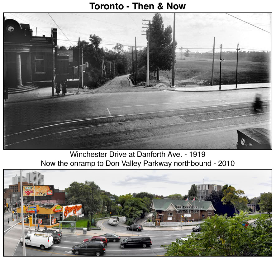
Which ties this string back to where it started, although the "Stadium" name and details still to be determined.
Last edited:
adma
Superstar
I question the claim that it was intended for "tube" let alone a North Am gauge subway. I'd read previously (and the loading size bears this out) it was for a pending CPR plan to run a passenger line across East York and Scarborough. I'll search for clarity on that point, albeit the sharp curves stymied (so the story goes) doing that for subway.
Most likely something like this
http://www.atlasobscura.com/places/streetcar-deck-of-the-detroitsuperior-bridge
steveintoronto
Superstar
Indeed. As much as the Viaduct was very prescient in planning for future rail use on the lower deck, it was far from unique at the time. Somewhere there's a map of the CPR's ambition at the time to run a line across there and through East York. I'm still looking for it. I believe that was the original intention for the lower deck, but obviously it lends itself to a smaller loading gauge use like subway too.Most likely something like this
http://www.atlasobscura.com/places/streetcar-deck-of-the-detroitsuperior-bridge
Here's some reference, albeit far from what I'm looking for:
http://gondolaproject.com/2010/05/03/foresight-the-bloor-street-viaduct/[...]
At the time of first conception, R.C. Harris was the Commissioner of Public Works in Toronto. He was the brains behind the Viaduct and was a strong-headed and willful man. When conceiving and designing the Viaduct, he insisted upon incorporating a lower second deck to the bridge. This lower deck could allow for rail transport in the future, should it be required.
This was controversial because of the costs it added to the bridge and in the early 1910’s, there was no need for a rail or subway connection to the outlying suburbs. Toronto’s first subway line, after all, wouldn’t open until 1954, 46 years after the Viaduct opened to the public.
What R.C. Harris was doing, however, was not building a subway connection. Instead, he was leaving an essential tool in place for future generations to exploit should they decide to. [...]
Here's some other views:
http://spacing.ca/toronto/2016/02/25/subway-modern-at-50/[...]Built at a cost of $90,000 during construction of the bridge in the 1910s, the lower level was designed to carry streetcars at a time when the city was planning underground lines across the city.
[...]
Though there was also a viable subway deck on the Rosedale portion of the Prince Edward Viaduct, the TTC found it didn’t quite line up with the planned location of Sherbourne station, so a new bridge was required.
[...]
That latter reference to the Sherbourne Station is probably far more accurate than the "too sharp a bend" mantra touted by many if not most writers on the matter. I've studied the originally intended RoW, and it's far from being too sharp a bend, even for heavy rail passenger use.
Here's more on the 'streetcar' concept:
http://spacing.ca/toronto/2015/07/08/oldest-bit-toronto-subway-opened-50-years-ago/[...]
Four decades before completion of the Yonge line, Canada’s first subway, Toronto mayor Horatio Hocken proposed building a covered trench to carry streetcars from the waterfront to the city limit at St. Clair Ave.. Boston and New York had recently opened similar systems, and Hocken was keen to ensure Toronto kept up.
The tunnel would have followed Bay St. before jogging over to Yonge St. at Davenport Rd. Lines under Queen and Bloor streets were also imagined as part of the network.
“Toronto is notorious for postponing the necessary improvements until the cost has doubled or trebled,” Hocken warned. “A rapid transit system must be built eventually and the sooner the better and the cheaper.”
The cost of the Bay/Yonge line was pegged at $5.1 million in 1911.
Of course, nothing came of Hocken’s initial proposal. Voters rejected the cost, but the concept lived on.
http://spacing.ca/toronto/2015/07/08/oldest-bit-toronto-subway-opened-50-years-ago/
http://spacing.ca/toronto/2015/07/08/oldest-bit-toronto-subway-opened-50-years-ago/
“Toronto is notorious for postponing the necessary improvements until the cost has doubled or trebled,” - Prescient!
J T CUNNINGHAM
Senior Member
"I've studied the originally intended RoW, and it's far from being too sharp a bend, even for heavy rail passenger use."
Both your above, then the below re-quoted line, certainly shows that the cost is irrelevant when Public Money is at stake; even as now.
“Toronto is notorious for postponing the necessary improvements until the cost has doubled or trebled,” - Prescient!"
Regards,
J T
Both your above, then the below re-quoted line, certainly shows that the cost is irrelevant when Public Money is at stake; even as now.
“Toronto is notorious for postponing the necessary improvements until the cost has doubled or trebled,” - Prescient!"
Regards,
J T
steveintoronto
Superstar
You're spot on JT! Lamport discusses the point making vague references to the owners of some of the adjacent properties and "who owns them" (insinuation being Family Compact or Montreal Anglo establishment) as the cause of a lot of costly alterations to the original route. It may be the fodder for another string to discuss this, I don't want to get too far away from 'evocative-images'...but I'm sure many of us could imagine the image of those interfering then, and still doing so in the machinations of this city."I've studied the originally intended RoW, and it's far from being too sharp a bend, even for heavy rail passenger use."
Both your above, then the below re-quoted line, certainly shows that the cost is irrelevant when Public Money is at stake; even as now.
“Toronto is notorious for postponing the necessary improvements until the cost has doubled or trebled,” - Prescient!"
Regards,
J T
I'll see if I can find the Lamport references and post, it was in the last few links I read. What did save a sizable sum is the foresight to do as other cities have done, and build a usable lower deck for rail on the Bloor Viaduct.
As a slightly off-topic reference to today, but along that line of thought, the DRL should be built with *full loading gauge* to utilize the tunnel for RER extending far out to the 905 suburbs and beyond. The thinking applied back then, it should now.
Edit to Add: Just found the quote from Lamport, albeit a slightly different source, but corroborating my claim, and the prior source:
[...]
In all, using the Prince Edward Viaduct cut $10 million off the cost of building the Bloor-Danforth line.
Though there was also a viable subway deck on the Rosedale portion of the Prince Edward Viaduct, the TTC found it didn’t quite line up with the planned location of Sherbourne station, so a new bridge was required.
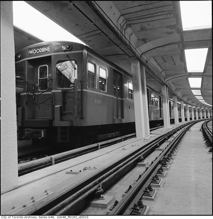
The solution, supplied by architect John B. Parkin and U.S. engineering firm DeLeuw, Cather & Co., was an open spandrel structure with a sweeping reinforced concrete arch. The deck, almost 17 metres above the valley floor, was almost entirely enclosed to prevent train noise disturbing residents of the nearby Kensington Apartments.
In 1968, city controller Allan Lamport said the builders of the apartments—the Samuel Bronfman family—had pressured the TTC into finding ways to reduce noise with the design of the bridge, which may have resulted in the roof being added.
“If you know who the building belonged to, you’d know how the pressure was put on,”Lamport said.
Two rows of skylights provided ventilation through the roof of the bridge, but were later covered. Now it’s hard for subway riders to discern that they’re traveling high above a ravine, save for an increase in noise as the train rumbles along its concrete guideway. [...]
http://spacing.ca/toronto/2016/02/25/subway-modern-at-50/
Last edited:
Goldie
Senior Member

J T CUNNINGHAM
Senior Member
"If you know who the building belonged to, you’d know how the pressure was put on,”Lamport said.
With all due respect to the memory of Allan Lamport, he living in a house on Harper Aveue,
just north of where St Clair dead-ends east of Mt Pleasant,
it certainly appears that he was not within a Gross Sound Interference Area, other than auto traffic.
Bear in mind, a number of Low Rise apartments had been added to that mix, along with a numer of Rooming Houses
and the term Block-Busting was running rampant Stateside, for more reasons than just one.
Regards,
J T.