|
|
|


You are using an out of date browser. It may not display this or other websites correctly.
You should upgrade or use an alternative browser.
You should upgrade or use an alternative browser.
Evocative Images of Lost Toronto
- Thread starter LowPolygon
- Start date

Goldie
Senior Member

Goldie
Senior Member
This intersection will be a busy place next weekend during the Taste of Danforth event.
Danforth-Broadview, S/E corner - Playter's Society Hall 1911

Broadview at Danforth, looking S., 1954

Danforth-Broadview, S/E corner - Playter's Society Hall 1911
Broadview at Danforth, looking S., 1954
Attachments


steveintoronto
Superstar
That would be a velodrome. "Velo" = bicycle. The sport of bicycle track-racing was very popular in Toronto and many other world cities at the time.amazing that that track is banked.....wonder what raced there???
steveintoronto
Superstar
Studying this pic very closely, wondering what the 'stadium roof' structure would be to the southwest of pic...only to notice why the streetcar is stopped. Broke the transom pole, being replaced, that must be a TTC truck behind the streetcar, ostensibly fixing the catenary.Broadview at Danforth, looking S., 1954
View attachment 117192
I'm assuming that streetcar had come up Broadview from King. Which loop was it about to turn on? Was there one about where the Broadview Station is now?
Goldie
Senior Member
Yes, the streetcar loop was at the present subway station.
I also noticed the stadium-like structure at the right of the photo.
There was once a baseball field/park in that area -- I watched a few games there--- long before the present school was built.
However, I don't recall any large stadium seating.......perhaps the school added that seating to their sports field.
Last edited:
steveintoronto
Superstar
Not the same lens angle, or the same focal point, but this gives a reasonable comparison to today:Yes, the streetcar loop was at the present subway station.
I also noticed the stadium-like structure at the right of the photo.
There was once a baseball field/park in that area -- I watched a few games there--- long before the present school was built.
However, I don't recall any large stadium seating.......perhaps the school added that seating to their sports field.
Studying the area where the 'stadium roof' appears in your B&W shot by using Google earth *appears* to reveal a different grade for that spot. I have to wonder if the DVP didn't witness large earth movements at that corner after the older shot?
Very interesting...maybe some of the others might have the story on that?
Here's a shot lacking in proximity but clearly showing a later development (still standing) on the spot in question:
Since:
History: Proposed 1954
Opened August 31, 1961 –
November 17, 1966[1]
https://en.wikipedia.org/wiki/Don_Valley_Parkway
And the pic being discussed is dated '54, something might have been razed in that interim. Any posters have more clues?
Attachments


Goldie
Senior Member

steveintoronto
Superstar
Incredible digging! I'm now more intrigued than ever on the story of that area. And the continuing question: Is life better today? Best I stop there, save to note what is now the ramp to the DVP being a road already extant at that time. That must have been a naturally formed ravine.Hers' a 1953 aerial photo of Broadview-Danforth area.
Top circle is the TTC loop.
Middle circle, the baseball field I previously mentioned.
Bottom circle, appears to be a new track & stadium.
44 North
Senior Member
Yeah it used to be Don Mills Rd going down that ravine, then connecting with Winchester St and Don Rdwy at the "subway" underpass below former CP rwy (the one still u/c to be expanded for cyclists). In 1951 Princess Elizabeth and the Duke of Edinburgh visited and crowds gathered along the natural amphitheater. You can see the stadium lights in the background. It's all former landfill along East Riverdale that still requires venting, and is arguably better today (even with the DVP bisecting the valley).


composite map spanning 1890-1920

composite map spanning 1890-1920
Attachments


steveintoronto
Superstar
I've done some cursory digging, there's no shortage of astounding pics on the Danforth and Broadview (which BlogTO had a piece on) but that promontory playing field area is hard to find pics of, at least so far. I also noted the "stadium lights" in a number of pics of the general area, they're hard to miss, but actual details are hard to find. I'll keep looking. I keep getting waylaid with all the other fascinating pics, some of which show *four tracks* for streetcars on The Danforth at one time, and three on Broadview. Whether that's competing companies w/ different track gauge (standard v. TTC) is a good question. The name "Eric Filey" has come up in a few blogs as a noted photographer on historical matters, I wonder if that's the father of Mike Filey?
Your last link is fascinating. I note the name for the ex-Don Mills Road as "Winchester Drive". That's a handy search tag. I do have to question the 'improvement' with the DVP though. Note "Riverdale Park" being contiguous across the valley, complete with connecting paths and roads. The railways didn't block passage, the DVP does. Whether the 'bowl' is on top of waste deposit is an interesting question. Certainly closer to the Don that was the case, incinerator waste at the least.
See: http://www.blogto.com/city/2013/03/what_broadview_avenue_used_to_look_like_in_toronto/
As I've mentioned for a number of these incredible pics of the past, they're 'portals' that may give a falsely idyllic view on things, as discussed here:
https://www.thestar.com/life/food_wine/2014/06/06/a_drink_with_derek_flack.html
That being said, I become immersed in some...many of these pics...and have to come up for air or be overcome with a nostalgia for something before my time. These photo forums are a 'safe place' for retrospect and understanding. And highly addictive...
Edit to Add: This is probably redundant for many of the posters here, but for me, and perhaps some other occasional dabblers, a treasure trove of links:
http://www.blogto.com/city/2011/12/the_history_of_toronto_in_photos/
Last edited:
Goldie
Senior Member

steveintoronto
Superstar
Still coming up blank on searching for the playing fields and stadium, if I could trip across a name for it, it would greatly assist searching, so putting that aside for now, there's a lot on the "Winchester Street and Drive" that I'm finding. Once again, I defer to Blog TO: (This is showing from Google search, not TO Blog's own search function)
[...]
A later incarnation of the Winchester Street Bridge after renovations in 1909.
Edit to Ask: Any guesses on that railway bridge behind Winchester Bridge? I know a rail line used to run up the Don on the east side as well as west side south of the CP's present idle crossing point.
See here: (Gerard St Bridge new)
http://www.blogto.com/city/2012/09/a_brief_history_of_crossing_the_don_river/[...]
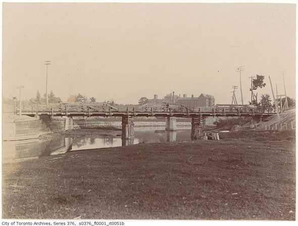
Scattered throughout the valley are several abandoned, seldom used, and vacant spaces left by demolished former bridges that once crossed the Don at the river bank rather than the valley wall. Almost every major crossing point south of the Evergreen Brick Works is on its second or third bridge, with the old structures torn down in favour of greater strength, width and height.
The first crossings over the lower Don River, once a powerful, meandering waterway prior to a major engineering project in the late 1800s, were probably nothing more than logs lashed together over a narrow part of the water, much like Playter's Bridge, (shown above, and drawn by Elizabeth P. Simcoe, the wife of John Graves Simcoe).
Playter's Bridge was located parallel to Winchester Street in today's Cabbagetown - a road that once continued down into the Don valley past Necropolis Cemetery. The same crossing point would later be home to the first major bridge over the Don, the larger Winchester Street bridge, shown below with The Isolation Hospital - a precursor to Bridgepoint Health - in the background. The Riverdale Park pedestrian bridge stands just south of the old Winchester Street crossing, which is now, sadly, gone. [...]
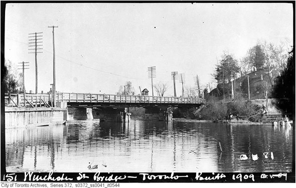
[...]
A later incarnation of the Winchester Street Bridge after renovations in 1909.
Edit to Ask: Any guesses on that railway bridge behind Winchester Bridge? I know a rail line used to run up the Don on the east side as well as west side south of the CP's present idle crossing point.
See here: (Gerard St Bridge new)
Last edited:
44 North
Senior Member
Nice map, Goldie. Has a good style...never seen it before. And yeah the Winchester crossing as well as the Queen crossing always interested me. They were gateways to the then wild country. There's some good sketches online I have saved to my hd somewhere. Wonder what the toll would've been, or the punishment for not paying up. Scadding owned the Queen one, and his adjacent home is TO's oldest surviving building (now at the Ex).
Back to the stadium. It's a mystery. Never saw it on a map, and only appears briefly in aerial photos between ~1950-60. Looked online and the scant info says it probably is Millen Stadium, or Millen Memorial Stadium. Archived G&M article says originally called Viaduct Stadium before honouring Millen.
Back to the stadium. It's a mystery. Never saw it on a map, and only appears briefly in aerial photos between ~1950-60. Looked online and the scant info says it probably is Millen Stadium, or Millen Memorial Stadium. Archived G&M article says originally called Viaduct Stadium before honouring Millen.
Last edited:
steveintoronto
Superstar
Figured it out, Googling took me to "Rare Maps" at this site, and many of the posters in this string, and then found a link in the Rare Maps string toEdit to Ask: Any guesses on that railway bridge behind Winchester Bridge? I know a rail line used to run up the Don on the east side as well as west side south of the CP's present idle crossing point.
http://oldtorontomaps.blogspot.ca/2013/01/1892-toronto-street-railway-lines.html
And then to this map:
http://maps.library.utoronto.ca/datapub/digital/NG/historicTOmaps/1892TorontoRailwayCompanyMap2.jpeg
Excellent leads!Back to the stadium. It's a mystery. Never saw it on a map, and only appears briefly in aerial photos between ~1950-60. Looked online and the scant info says it probably is Millen Stadium, or Millen Memorial Stadium. Archived G&M article says originally called Viaduct Stadium before honouring Millen.
Toronto had quite a number of 'recreation parks' albeit this one appears to be a latter one. Some of the out-of-town ones, often served by interurban lines, are hard to find info on.
Edit to Add: Found reference to "Viaduct Stadium" but not the same one:
http://www.blogto.com/city/2012/11/that_time_when_toronto_went_stadium_crazy/It's worth noting that the route for the subway hadn't been finalized in the above map and two possible alignments are shown: one over the Prince Edward Viaduct and one under the Don Valley further south. Had a stadium been approved for Riverdale Park it's possible the route of the Bloor-Danforth line could have been altered to accomodate the project.
[...]

