News   Apr 19, 2024
 436     0 
News   Apr 18, 2024
 1.1K     1 
News   Apr 18, 2024
 9.4K     2 

Cycling: Simcoe Street changes for bike lanes

How far are they extending the bike lanes North? Would be an ideal N-S route on the West side of downtown (like Sherbourne on the east) if they were able to continue it from Queens Quay all the way to Bloor (and eventually the Dupont bike lanes). Would make drivers happy (less bikes on University/Bay/Yonge) and would really make it an easy commute to downtown.


I'm thinking (from South to North):

Simcoe north to Queen
Bike lights at Simcoe on Queen (no pedestrian lights which reduces the cycle time for the lights)
Throught the Simcoe pedestrian zone in the Canada Life complex
Back onto Simcoe Street to Elm (need to have counterflow on this street...one way going North)
Bike lights needed at Dundas for this stretch
Elm does not need significant changes...just ban parking for this small section
Murray to College (or whatever that laneway is that extends north from Murray)...ban parking at least on one side of the street to create a bike lane
somehow wind up through UofT to Bloor

I don't think the northbound lanes will go beyond Richmond.

Maybe Murray-Orde-McCaul? That at least puts you within reach of King's College Rd.
 
From City today:

News Release

July 7, 2014

Changes to Toronto's Simcoe Street to benefit drivers and cyclists

The City of Toronto has initiated road changes to Simcoe Street, including the creation of a new traffic lane and the installation of cycle tracks among other changes, in an effort to improve the movement of traffic for drivers and cyclists.

"Fighting traffic congestion and making our streets safer is a top priority of mine. I am confident that these changes will reduce delays for motorists and make our streets safer for cyclists as they move around the downtown core," said Mayor Rob Ford. "This initiative is the next step in our aggressive plan to fight traffic congestion and make it easier to get around our great city."

"The installations are just one more part of the City's overall congestion management plan that will help all road users move more effectively in this area," said Councillor Denzil Minnan-Wong (Ward 34 Don Valley East), Chair of the City of Toronto's Public Works and Infrastructure Committee.

The changes will provide a safer bikeway connection between Queens Quay and the new cycle tracks that will be installed later this month on Richmond Street West and Adelaide Street West. The change to two-way traffic between Front Street West and Wellington Street West will help to improve the flow of northbound traffic from Simcoe Street to Wellington Street.

The following changes will be made to Simcoe Street, effective July 9:

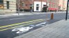
• Between Front Street and Wellington Street, Simcoe Street will be converted to two-way operation for all road users. A new traffic lane will be created in the northbound direction in addition to cycle tracks (separated bike lanes) on each side of the street.

• Between Queen Street West and Wellington Street, Simcoe Street will remain one-way southbound for motor vehicles. However, cycle tracks will be installed in both directions on the street. The existing traffic signals will be modified to provide traffic signal displays for cyclists travelling in the northbound direction.

• An extra wide, shared curb lane will be provided in the southbound direction between Queen Street and Richmond Street and between King Street and Wellington Street to accommodate pickup and dropoff activity in those two blocks.

This news release is also available on the City's website: http://bitly.com/1mBDBXi

Toronto is Canada's largest city, the fourth largest in North America, and home to a diverse population of about 2.8 million people. It is a global centre for business, finance, arts and culture and is consistently ranked one of the world's most livable cities. Toronto is proud to be the Host City for the 2015 Pan American and Parapan American Games. For information on non-emergency City services and programs, Toronto residents, businesses and visitors can visit http://www.toronto.ca, call 311, 24 hours a day, 7 days a week, or follow us @TorontoComms.
 
The northbound bike lane is all the way to Queen. But it means crossing Richmond Street which still only gets a stop sign.

I cross there on foot a lot....it is a pretty easy crossing...combo of the one-way street and the nearby lights at University leave regular large gaps i traffic.....if an old guy like me can get across on foot easily, I am sure someone on a bike should have not trouble.

What I find hilarious is how the press release characterizes these changes as good for both cars and bikes because they are creating a new traffic lane between Front and Wellington! they are not creating a new traffic lane....they are repurposing one for bikes and redirecting one for northbound traffic.....the most frequent users of this road (ie...evening rush car drivers) will, no doubt have a hard time viewing this as an improvement and will have a hard time acknowledging the creation of a new traffic lane.

This may be a good thing overall (I doubt it but am open minded enough to give it a chance) but I am not sure why they have to lie like that in describing it.
 
The northbound bike lane is all the way to Queen. But it means crossing Richmond Street which still only gets a stop sign.

Ah, okay. Maybe there will be a signal once the lanes become fully operational tomorrow. I haven't biked north on it yet because beyond the stretch north of Adelaide it seemed to get a little hairy with southbound cars decidedly not leaving space for northbound bikes.
 
Here is what the street looks like between King and Pearl as of this morning and a story in the star about more aggressive enforcement.

http://www.thestar.com/news/gta/tra...tion_to_target_illegal_bike_lane_parking.html

IMG_20140708_095134.jpg
 

Attachments

  • IMG_20140708_095134.jpg
    IMG_20140708_095134.jpg
    100.4 KB · Views: 675
Last edited:
Some time between about noon and, well, now....these bike lanes and their northbound cyclist only traffic signals went live.
 
So...a further change today and I am not sure why. They have painted what I can only describe as two parking "boxes" on the west lane south of Pearl.

So now the southbound traffic north of King has to take the left lane to get past these two parked cars only to get stuck behind the cars turning left onto King before moving over to the right lane again because the left lane disappears half way to Wellington.

Really not sure what value/importance someone put on 2 parking spots!?!?

They're off-peak parking spaces and they seem to work well so far.
 
They're off-peak parking spaces and they seem to work well so far.

When I posted that I had just witnessed them not working so well....6:45 on a thursday night, the combo of two cars in those spots and a few cars turning left plus the normal level southbound traffic led to it taking 3 light cycles to get from Pearl to through King St.
 
When I posted that I had just witnessed them not working so well....6:45 on a thursday night, the combo of two cars in those spots and a few cars turning left plus the normal level southbound traffic led to it taking 3 light cycles to get from Pearl to through King St.

They seemed to be in use again just now (8:15 am ... not sure how that qualifies as off-peak) and the bigger problem seemed to be cars parking in the bike lanes (again! still!) and then trying to get back into traffic near those spaces.

The biggest problem I have with the new setup is the single lane southbound at Wellington, because most of the traffic is looking to turn right (west) instead of going south.
 
I tried out the new lanes yesterday, and they're nice. However I don't understand why the city is so adverse to putting in those cheap flexible bollards to keep cars out. They can easily be knocked down by emergency vehicles if need be. They are especially important on the northbound lanes, as I quickly realized when vehicles were parked in them, I had to detour around them directly into oncoming traffic...
 
They seemed to be in use again just now (8:15 am ... not sure how that qualifies as off-peak) and the bigger problem seemed to be cars parking in the bike lanes (again! still!) and then trying to get back into traffic near those spaces.

Took note of the times on the parking signs today....Monday to Saturday 8 a.m. to midnight...and Sundays 1pm to midnight. Off peak?

The biggest problem I have with the new setup is the single lane southbound at Wellington, because most of the traffic is looking to turn right (west) instead of going south.

From a car perspective it is a bit of a mess......Southbound North of King the combo of bike lanes force cars into left lane of the two....then they have to get over to the right about halfway between King and Wellington (as the left disappears halfway) then south of Front scoot over the left again (not sure if it reverts to two lanes after the construction there is done or not).

So not only have they taken an effective afternoon rush route from 3 to 1 - 1/2 lanes they have forced a lot lane changing and weaving. I hope the cycling use increases quickly (it can be described as no more than sparse/sporadic so far) otherwise this will become a poster child for the anti-cycling infrastructure crowd.
 

Back
Top