News   Nov 22, 2024
 399     1 
News   Nov 22, 2024
 836     4 
News   Nov 22, 2024
 2.1K     6 

Cycling infrastructure (Separated bike lanes)

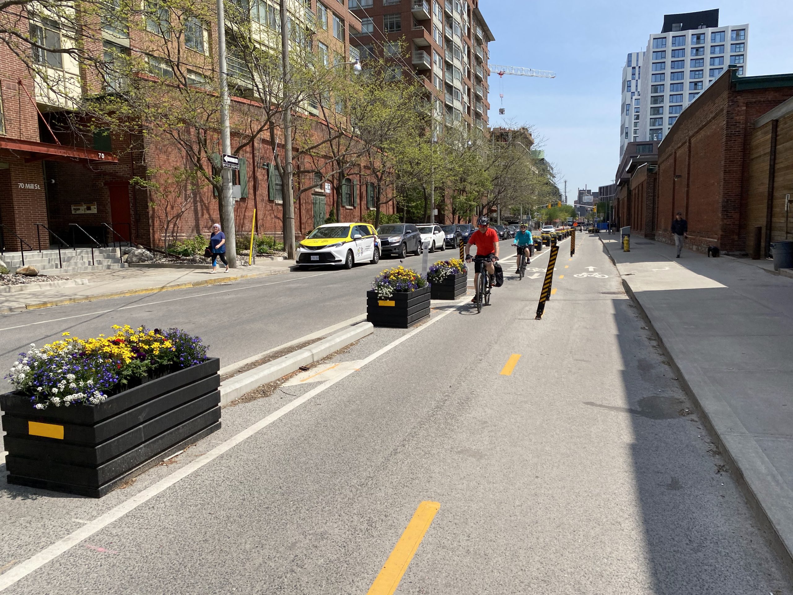
Feedback for the Palmerstone-Tecumseth Cycling Connections project is open until Nov 3! They've also uploaded the presentation from the Public Meeting. Have your say :)


Quite a lot of "wayfinding sharrows" implemented which is a bit disappointing. Seems like there's still quite a bit of emphasis on on-street parking.

I used to ride along this route to work pre-pandemic for ~3 years, so overall very excited to see it becoming another official N-S connection!

PT.PNG

 
Feedback for the Palmerstone-Tecumseth Cycling Connections project is open until Nov 3! They've also uploaded the presentation from the Public Meeting. Have your say :)


Quite a lot of "wayfinding sharrows" implemented which is a bit disappointing. Seems like there's still quite a bit of emphasis on on-street parking.

I used to ride along this route to work pre-pandemic for ~3 years, so overall very excited to see it becoming another official N-S connection!

View attachment 357323


Looking at that image, its not hard to see where room could be found for either a bike lane/cycle track heading south, or, a bi-directional path.........(looks suspiciously at that parking).

The key is for any people here who know the area well to assess whether that parking is fully utilized and by whom (residents vs visitors)

If there is minimal use by residents, its worth pushing to take it out as part of this project.

If residential use is high, its probably not worth the hassle/ill-will and a high probability of losing.......(today).........get what we can, come back for better later.
 
Do you have any examples of the above? I'd be interested to see how that works in practice and or/would work in practice in our examples. (Roncy is the obvious one, but we've started doing this on Christie, and I think a couple of other spots as well)

I would add, w/o judging your idea in the least, that I think its important to compare this design w/the baseline alternative, which is a bus pulling over and blocking the bike lane, or more challenging vehicle boarding/alighting for passengers from transit vehicles away from the curb, w/passengers stepping down into the curb/bike lane.
It's the standard approach in the Netherlands.

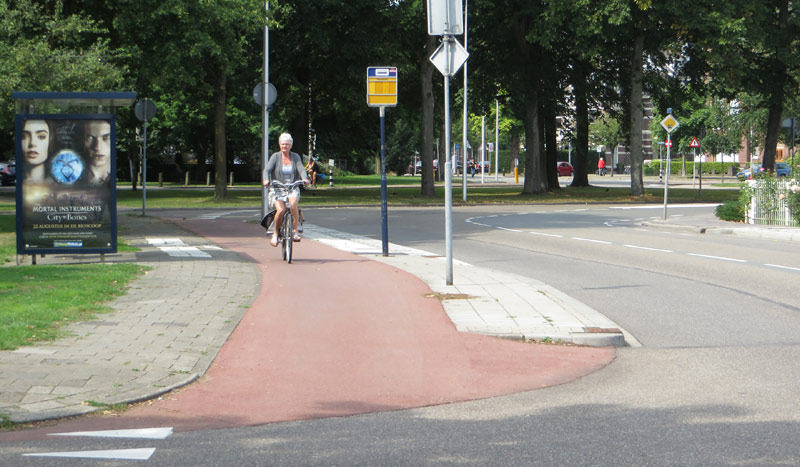
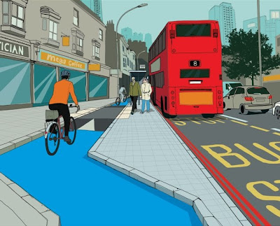
An example from central Amsterdam:
1634916112505.png


Sometimes the shelter/signage is also on the other side of the bike path with the small unloading/loading platform being even narrower.
 
It's the standard approach in the Netherlands.

An example from central Amsterdam:
View attachment 357355

Sometimes the shelter/signage is also on the other side of the bike path with the small unloading/loading platform being even narrower.

Interesting, thanks for that.

Can say, that won't be approved here in that form, it would be considered non-compliant with our accessibility rules. That certainly don't look to be 2.1M unencumbered, which is the requirement.

I'd add as well though, that design provides net to no shelter for transit users.

Non-starter here.

On a wide enough road (University/Avenue, the big suburban arterials) we could certainly do something like this, but with adequately large platform areas, if transit is curbside.

But this won't happen on narrower streets in the old city.
The bus stop area I showed looks to be about 2.2m wide measuring on Google Maps, so it actually would comply with our accessibility rules, or would comply with a few minor adjustments.

As for the bus shelter, obviously a shelter in Toronto needs to be more substantial than one in Amsterdam, and there is no reason why the shelter couldn't be made larger with the same layout. The shelter can also be placed on the other side of the cycle track if necessary.

That tram stop in Amsterdam is on Ferdinand Bolstraat, a very narrow street significantly narrower than any relevant Toronto street. The typical distance between building facades on that section of Ferdinand Bolstraat is about 14m, so narrow that the tram is single track. Where this specific stop is located, there is a square off to one side and the street widens a little bit in order to accommodate this tram stop as well as double track, to about 18-19m measure from building facade to the bicycle parking on the other side:
1634949008740.png
1634949097921.png
1634949359969.png


Roncy is about 19-20m between sidewalk edges and building facades, which is wider than that street in Amsterdam even where it widens into the square to accommodate the tram stop. Christie is similar at about 18-19m and in fact pretty much all major streets in the older parts of Toronto have a 20m ROW, and in most cases the sidewalk goes right up to the edge of the ROW or really close, so they're all basically the same. And, in most cases the stops will not be directly across from each other like on Ferdinand Bolstraat, they are staggered on opposite sides of an intersection, freeing up even more ROW width which can be added to sidewalks or used for street furniture or trees/plants.

There is absolutely enough space for the Dutch treatment on all of the narrow 20m ROW arterials in Old Toronto, as long as we are OK with having two travel lanes for cars, which is already the case on most of these streets, where curb lanes are always filled with parked cars or other things.

I see no good reason why the Dutch solution cannot work in Toronto.

The Toronto design blocks the entire cycle track whenever there is a streetcar, especially if accessibility ramps are deployed or if there are many passengers boarding or alighting. It also introduces conflict points in a much worse position, as if a cyclist fails to stop, and someone exiting the streetcar does not look to the side before stepping off, they will hit each other. Because the bike lane is directly adjacent to the streetcar doors, there is no direct line of sight between an alighting passenger and a cyclist until the passenger is halfway out of the streetcar and about to step on the bike lane. The line of sight is blocked by the doors of the streetcar.

The Dutch design allows cyclists to still go through when a tram is stopping, and it gives enough space for people to exit the tram so that when they begin crossing the cycle track, they have already spent a few seconds outside the tram, so both the exiting passenger and any cyclists have time to see each other and react appropriately. It also speeds up boarding and alighting as people can wait closer to where the tram stops.

Really, the general idea isn't even new to Toronto, it's basically the same as the eastbound streetcar stops on Queens Quay, which happen to be about the same width as the stops on Ferdinand Bolstraat - about 2.3m.

Of course, the stops on Roncy and other places are better than nothing, they are certainly a step in the right direction, but I think it's hard to argue that the Dutch solution is not the best solution, and this really applies to almost everything in cycling infrastructure.
 
The bus stop area I showed looks to be about 2.2m wide measuring on Google Maps, so it actually would comply with our accessibility rules, or would comply with a few minor adjustments.

As for the bus shelter, obviously a shelter in Toronto needs to be more substantial than one in Amsterdam, and there is no reason why the shelter couldn't be made larger with the same layout. The shelter can also be placed on the other side of the cycle track if necessary.

That tram stop in Amsterdam is on Ferdinand Bolstraat, a very narrow street significantly narrower than any relevant Toronto street. The typical distance between building facades on that section of Ferdinand Bolstraat is about 14m, so narrow that the tram is single track. Where this specific stop is located, there is a square off to one side and the street widens a little bit in order to accommodate this tram stop as well as double track, to about 18-19m measure from building facade to the bicycle parking on the other side:
View attachment 357529View attachment 357530View attachment 357531

Roncy is about 19-20m between sidewalk edges and building facades, which is wider than that street in Amsterdam even where it widens into the square to accommodate the tram stop. Christie is similar at about 18-19m and in fact pretty much all major streets in the older parts of Toronto have a 20m ROW, and in most cases the sidewalk goes right up to the edge of the ROW or really close, so they're all basically the same. And, in most cases the stops will not be directly across from each other like on Ferdinand Bolstraat, they are staggered on opposite sides of an intersection, freeing up even more ROW width which can be added to sidewalks or used for street furniture or trees/plants.

There is absolutely enough space for the Dutch treatment on all of the narrow 20m ROW arterials in Old Toronto, as long as we are OK with having two travel lanes for cars, which is already the case on most of these streets, where curb lanes are always filled with parked cars or other things.

I see no good reason why the Dutch solution cannot work in Toronto.

The Toronto design blocks the entire cycle track whenever there is a streetcar, especially if accessibility ramps are deployed or if there are many passengers boarding or alighting. It also introduces conflict points in a much worse position, as if a cyclist fails to stop, and someone exiting the streetcar does not look to the side before stepping off, they will hit each other. Because the bike lane is directly adjacent to the streetcar doors, there is no direct line of sight between an alighting passenger and a cyclist until the passenger is halfway out of the streetcar and about to step on the bike lane. The line of sight is blocked by the doors of the streetcar.

The Dutch design allows cyclists to still go through when a tram is stopping, and it gives enough space for people to exit the tram so that when they begin crossing the cycle track, they have already spent a few seconds outside the tram, so both the exiting passenger and any cyclists have time to see each other and react appropriately. It also speeds up boarding and alighting as people can wait closer to where the tram stops.

Really, the general idea isn't even new to Toronto, it's basically the same as the eastbound streetcar stops on Queens Quay, which happen to be about the same width as the stops on Ferdinand Bolstraat - about 2.3m.

Of course, the stops on Roncy and other places are better than nothing, they are certainly a step in the right direction, but I think it's hard to argue that the Dutch solution is not the best solution, and this really applies to almost everything in cycling infrastructure.

Well argued.

Good evidence.

I will reflect on that some.
 
The new contra-flow techniques planned for Palmerston-Tecumseth look great! People have complained about sharrows in a few places but it seems to be taken out of context.

The contraflow lanes (just paint) are adequate considering the space and street use. The city will be reversing directions on a lot of the blocks. A mix of sharrows, bike lanes, contraflow, cycle tracks, and reducing cut-through traffic will make this corridor a whole lot more quieter and comfortable.
 
From KWT's newsletter:
I hadn't heard of this project. I got excited there, I hoped they'd provide a bus lane to connect Esplanade to Mill Street, and avoid the lengthy (and slow) detours up to Front.

But it's all bike/pedestrian - which didn't seem to be too bad between Parliament and Berkeley already.

Here's the webpage:

 
Do you have any examples of the above? I'd be interested to see how that works in practice and or/would work in practice in our examples. (Roncy is the obvious one, but we've started doing this on Christie, and I think a couple of other spots as well)

I would add, w/o judging your idea in the least, that I think its important to compare this design w/the baseline alternative, which is a bus pulling over and blocking the bike lane, or more challenging vehicle boarding/alighting for passengers from transit vehicles away from the curb, w/passengers stepping down into the curb/bike lane.
Something like this:
wilhelminapark2013.jpg

From: https://bicycledutch.wordpress.com/2013/09/05/riding-around-the-bus-stop/


Other examples:

More in line with how Toronto would do things:
wartonroad.jpg
 
Interesting, thanks for that.

Can say, that won't be approved here in that form, it would be considered non-compliant with our accessibility rules. That certainly don't look to be 2.1M unencumbered, which is the requirement.

I'd add as well though, that design provides net to no shelter for transit users.

Non-starter here.

On a wide enough road (University/Avenue, the big suburban arterials) we could certainly do something like this, but with adequately large platform areas, if transit is curbside.

But this won't happen on narrower streets in the old city.
Accessibility can be addressed by raising the bike path the level with the sidewalk and keeping the shelter on the sidewalk proper instead of the loading bay.
 
Something like this:
wilhelminapark2013.jpg

From: https://bicycledutch.wordpress.com/2013/09/05/riding-around-the-bus-stop/


Other examples:

More in line with how Toronto would do things:
wartonroad.jpg

The top 2 examples, while interesting, are highly anomalous in terms of what we would see here, they involve huge set backs before any buildings/structures are found.
 
I hadn't heard of this project. I got excited there, I hoped they'd provide a bus lane to connect Esplanade to Mill Street, and avoid the lengthy (and slow) detours up to Front.

But it's all bike/pedestrian - which didn't seem to be too bad between Parliament and Berkeley already.

Here's the webpage:

The idea of a bus route between The Esplanade and Mill was examined and rejected. It would have gone on northern end of Parliament Square Park and southern end of what was, at that time, the First Parliament park area. Now that the 121 eastbound bus goes north to Front @ Princess the only bus that would use the suggested short-cut would be 121 westbound. It has FAR worse traffic nearer downtown so a short 'jog' is really not a problem. (BTW. In spring 2022 the bike and pedestrian route between Mill and The Esplanade will be split with bikes getting a new path along south side of what is now the Green P lot.
 

Back
Top