|
|
|


Recent content by StreetcarRider
-
S
Alto - High Speed Rail (Toronto-Quebec City)
Thanks Andy Takagi and colleagues: "Why Union Station may not be a stop on Canada’s new high-speed rail line" https://www.thestar.com/gift-redeem?t=499792d6-1a49-4593-88fc-09907240aac4- StreetcarRider
- Post #3,104
- Forum: Transportation and Infrastructure
-
S
Toronto East Harbour GO & Ontario Line Station | 14.35m | 1s | Metrolinx | HDR
Great pics! I've also visited the area and taken a peek through the open gates, and it seemed to me as if these bridges were not very high off the ground, compared to how high the new bridges at Eastern, Dundas and Logan are. Did you have the same impression? Maybe the Broadview extension...- StreetcarRider
- Post #646
- Forum: Buildings
-
S
Alto - High Speed Rail (Toronto-Quebec City)
Enjoying the jokes but truthfully: who gets compensated for expropriations, and by how much, is governed by law, including dispute processes. This article provides an overview of the expropriation, compensation and dispute processes, including exceptional rules just for Alto...- StreetcarRider
- Post #3,093
- Forum: Transportation and Infrastructure
-
S
Alto - High Speed Rail (Toronto-Quebec City)
That's partly what the consultation and site visits are for, to determine the final route. Others in this forum have well-explained the catch 22s of early public consultations. Anyway, don't take it from me, take it from Renfrew County's Reeve Peter Emon, when the council was recently asked to...- StreetcarRider
- Post #3,078
- Forum: Transportation and Infrastructure
-
S
Alto - High Speed Rail (Toronto-Quebec City)
It's as if that particular farmer thought the compensation was for pain and suffering rather than time and damage. Anyway, two additional stories on the farming situation. First, the National Farmers Union is calling to cancel Alto. It has published a long statement explaining its position...- StreetcarRider
- Post #3,076
- Forum: Transportation and Infrastructure
-
S
Alto - High Speed Rail (Toronto-Quebec City)
Somebody needs to start supporting this project loudly and publicly, in the places between Ottawa and Montreal. Here's what can happen when that isn't done properly. (Don't worry, I won't flood the forum with posts every time a town opposes Alto. Just pointing out a recent and remarkable...- StreetcarRider
- Post #3,072
- Forum: Transportation and Infrastructure
-
S
Cycling infrastructure (Separated bike lanes)
Not sure where to put these pictures so feel free to move. First, no obvious progress on the Riverdale ramp since the last pics in this thread, although there were two workers on site. Second, hope they plan to raise the level of the trail before it gets paved. See if you can spot the issue...- StreetcarRider
- Post #8,662
- Forum: Transportation and Infrastructure
-
S
Toronto Ontario Line 3 | Metrolinx
Hopefully that map was not final for some of the stations. By way of further thinking: - the stop at King/Bathurst should be called Fort York or something more unique than King West - the stop at Spadina/Queen should be called Queen West because that's the name of the neighbourhood - East...- StreetcarRider
- Post #26,170
- Forum: Transportation and Infrastructure
-
S
Cycling infrastructure (Separated bike lanes)
There's a dog park between Richmond and Adelaide on the east side of Power. The only way to access it is to cross a street. I took the pics last Friday at evening rush hour. It was crowded, chaotic and unsafe. It was immediately obvious that better traffic facilities are needed for the way...- StreetcarRider
- Post #8,641
- Forum: Transportation and Infrastructure
-
S
Cycling infrastructure (Separated bike lanes)
We're all entitled to our opinions. The city's opinion, in approving these changes, was: On Sunday May 19, 2019, a pedestrian was struck crossing Adelaide Street East at Power Street while making their way to the nearby dog park. Residents have identified ongoing road safety issues at Power...- StreetcarRider
- Post #8,636
- Forum: Transportation and Infrastructure
-
S
Toronto Regent Park: Phases 4 and 5 | 134.1m | 39s | Tridel | Karakusevic Carson Architects
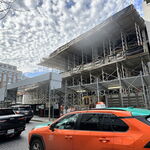
Some pics of recent progress- StreetcarRider
- Post #221
- Forum: Buildings
-
S
Toronto Ontario Line 3 | Metrolinx
Agreed, it's going to be great. Between now and then, of course, is the demolition of the DVP-Gardiner highway ramps and construction of the new ones. As much as I would like a reopening while that work is ongoing, it probably would be quite a bit safer to wait.- StreetcarRider
- Post #26,095
- Forum: Transportation and Infrastructure
-
S
Toronto East Harbour GO & Ontario Line Station | 14.35m | 1s | Metrolinx | HDR
Last piece going in…- StreetcarRider
- Post #623
- Forum: Buildings
-
S
East Don Trail Project
One of the truly interesting things about the Don Valley trail is that it is one of the few places in the city of Toronto where people don't follow the rules. The East Don Trail was built in part because people were already using the area when they weren't supposed to be. During the...- StreetcarRider
- Post #356
- Forum: Transportation and Infrastructure
-
S
Cycling infrastructure (Separated bike lanes)
Some more pictures from around Adelaide, Power and Richmond. What a nightmare at rush hour! Anyway, here's Power looking south from Richmond: Here's Richmond, looking west from Power- StreetcarRider
- Post #8,628
- Forum: Transportation and Infrastructure