You are using an out of date browser. It may not display this or other websites correctly.
You should upgrade or use an alternative browser.
You should upgrade or use an alternative browser.
Or with extending the Eglinton line along the transitway. I don't see the point.
It would maintain the connectivity of the Transitway to Renforth and the Airport for GO buses, but would also provide a rail-based connection to Square One from Toronto.
Not only would it allow buses to use the transitway after construction of the LRT, it would also be during construction so short sections of track can be laid while the bus transitway is still in service.
Very true. The configuration that I envision is the areas in between stations would just have tracks laid within the roadway (with buses driving over them, like streetcar tracks). At stations, the tracks would veer towards the outside lane and serve the station, while the inside bypass lanes would be for buses only.
GO and MiWay buses could continue express through the stations, while the LRT would make the station stops.
robmausser
Senior Member
It would maintain the connectivity of the Transitway to Renforth and the Airport for GO buses, but would also provide a rail-based connection to Square One from Toronto.
Very true. The configuration that I envision is the areas in between stations would just have tracks laid within the roadway (with buses driving over them, like streetcar tracks). At stations, the tracks would veer towards the outside lane and serve the station, while the inside bypass lanes would be for buses only.
GO and MiWay buses could continue express through the stations, while the LRT would make the station stops.
The more I think about this idea the more I like it
There could also be an LRT along the Hydro corridor from Kipling TTC/GO, and up the 407 to Lisgar. This way you maintain the relative path of the Milton Line. The hydro corridor LRT portion would connect with the Eglinton West LRT, with some trains continuing along the Transitway and some going to the airport.
As an added bonus you have an express LRT option from Kipling station to the airport. Shown in green:
adrianaliu
Active Member
ridership along these proposed routes wont justify rail for decades, not worth losing some of the gr8 brt flexibility for
TransitBart
Senior Member
Same line but terminus of the city portion westbound at Kipling. Terminus of Mississauga City Centre eastbound at Kipling. Take Milton Line eastbound on new RER into the city from Kipling. Go home Milton RER to Kipling and then change to westbound Line 2 subway. Sure Milton RER is a work in progress. Give it time.I've always pictured a subway extension to Square One running along the Milton GO corridor on the surface to save costs over such a long distance. Something like:
Cloverdale
Sherway
Dixie (At rail corridor)
Cawthra (at rail corridor)
Cooksville (at GO Station)
Central Parkway / Elm (at Kariya)
Burnhamthorpe (at Kariya)
Square One
Perhaps it could be split into two phases, the first one as a small extension to Sherway. That type of alignment would make it so the 12km would have maybe 5km tunneled and 7km above grade.
The main problem with this would be that travel times would be getting pretty extreme to get downtown. It's already almost 30 minutes to get from Kipling to Bloor-Yonge, plus the new line would add another 18-19 minutes of travel time. Going from Square One to downtown would probably still take an hour on the subway.
drum118
Superstar
One thing being over look is the Tram/Train that can run from Union to Sq One by Hurontario.
As for the Mississauga Transitway, it will remain as is for decade since the ridership is not there now nor 20 plus year as per the 2004 EA report.
Until there is a major redevelopment along Dundas, running LRT from Kipling/Cloverdale to Hurontario/Mavis is way down the road. From Hurontario/Mavis to Burlington will remain an express/light BRT/BRT well pass 2050 with most of the BRT being in Mississauga. Having LRT going pass Hurontario/Mavis will not happen until 2050, if then unless current development is rebuilt to support it.
Taking an LRT up the 407 ROW is dumb and fail to meet riders current needs or further needs elsewhere.
micheal_can
Senior Member
I have always thought that Line 2 should be extended west along Dundas into Mississauga. They already have a line to Vaughan, s it is only a matter of time.
drum118
Superstar
Why and Where??I have always thought that Line 2 should be extended west along Dundas into Mississauga. They already have a line to Vaughan, s it is only a matter of time.
Under the old plan, Line 2 was to run to Dixie Rd with no stops between it and Cloverdale.
Its a 5-10 minute walk from the GO Dixie station under the old plan without pulling all routes off route to service the Dixie Station. Doing this will add extra travel time to the riders already on the bus that will be the same as walking due to traffic.
Since GO/Metrolinx want that track area for line 2 for their line, CP ROW is out of the picture now.
Now what will it cost to tunnel line 2 along Dundas to Dixie or X point as well still servicing Dundas surface?? Do you built rough in station between Dixie and Cloverdale at the same time and where??
Hopkins123
Senior Member
Why and Where??
Under the old plan, Line 2 was to run to Dixie Rd with no stops between it and Cloverdale.
Its a 5-10 minute walk from the GO Dixie station under the old plan without pulling all routes off route to service the Dixie Station. Doing this will add extra travel time to the riders already on the bus that will be the same as walking due to traffic.
Since GO/Metrolinx want that track area for line 2 for their line, CP ROW is out of the picture now.
Now what will it cost to tunnel line 2 along Dundas to Dixie or X point as well still servicing Dundas surface?? Do you built rough in station between Dixie and Cloverdale at the same time and where??
Wharton Way says hello.
robmausser
Senior Member
One thing being over look is the Tram/Train that can run from Union to Sq One by Hurontario.
This could have been done if the Waterfront LRT was done as originally planned, as a separate LRT from the current streetcar system. You could have it continue along to Hurontario at Port Credit.
However since its now destined to use the existing streetcar trackage, it wouldn't be the right track gauge.
Bureaucromancer
Active Member
This could have been done if the Waterfront LRT was done as originally planned, as a separate LRT from the current streetcar system. You could have it continue along to Hurontario at Port Credit.
However since its now destined to use the existing streetcar trackage, it wouldn't be the right track gauge.
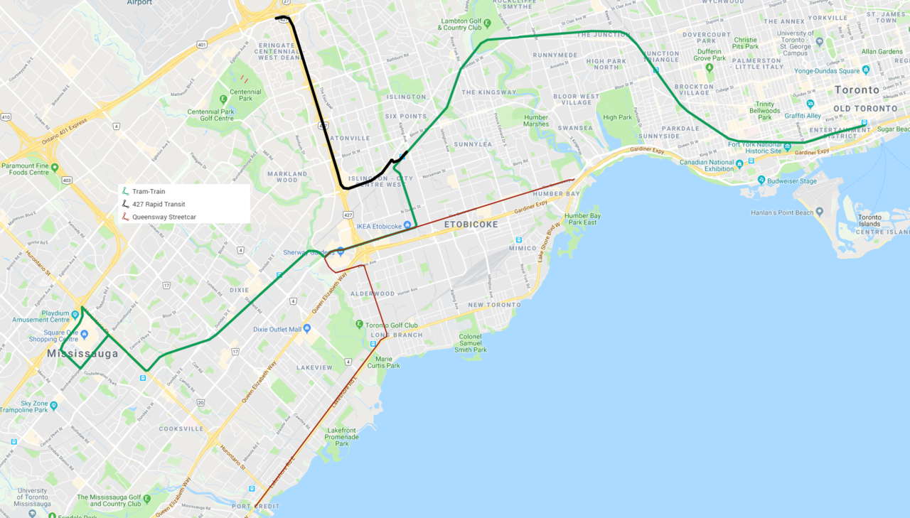
Thats not a tram train, just linking the light rail systems.
A tram train would run mainline from Union to Hurontario (every version I've heard of talks about Milton, but I guess you could use Lakeshore as well) and through runs onto the light rail system. One version basically requires the freight bypass and the other has track time issues (and I question how much an improvement it is, although just splitting at Square one and running southern branch service downtown is a very nicely simple service pattern).
Think something like:
Which is at the moment my preference in general, although it's from before the loop got dropped, would be contingent on the bypass and has a section on Queensway that would have to be dual guage as drawn above.
robmausser
Senior Member
Thats not a tram train, just linking the light rail systems.
A tram train would run mainline from Union to Hurontario (every version I've heard of talks about Milton, but I guess you could use Lakeshore as well) and through runs onto the light rail system. One version basically requires the freight bypass and the other has track time issues (and I question how much an improvement it is, although just splitting at Square one and running southern branch service downtown is a very nicely simple service pattern).
Think something like:
Which is at the moment my preference in general, although it's from before the loop got dropped, would be contingent on the bypass and has a section on Queensway that would have to be dual guage as drawn above.
A tram train on the CP corridor? Lol
micheal_can
Senior Member
Why and Where??
Under the old plan, Line 2 was to run to Dixie Rd with no stops between it and Cloverdale.
Its a 5-10 minute walk from the GO Dixie station under the old plan without pulling all routes off route to service the Dixie Station. Doing this will add extra travel time to the riders already on the bus that will be the same as walking due to traffic.
Since GO/Metrolinx want that track area for line 2 for their line, CP ROW is out of the picture now.
Now what will it cost to tunnel line 2 along Dundas to Dixie or X point as well still servicing Dundas surface?? Do you built rough in station between Dixie and Cloverdale at the same time and where??
With this LRT, just going to it would be a great thing.
drum118
Superstar
Mark your calendar: August 30 - September 2
The new Alstom Light Rail Vehicle (LRV) mock-up is coming to Mississauga over Labour Day weekend!
Tour the mock-up vehicle at Square One Shopping Centre, Entrance 7, near both the MiWay and GO Bus Terminals from Friday, August 30th to Monday, September 2nd. Transit fans, commuters and back-to-school shoppers in the Peel region will have the opportunity to tour the vehicle for the first time and take photos of themselves with it.
Alstom LRVs will connect the cities of Mississauga and Brampton via the Hurontario LRT line in the near future. Just down the street from the mock-up site, the Hurontario LRT’s City Centre stop will connect future transit riders to the MiWay and GO Bus Terminals, to create even more connections in the Peel region.
Visit https://www.facebook.com/events/2935409779864079/ for more event details.
Please share widely with your colleagues/friends/members.
Allandale25
Senior Member
Preferred Proponent Announced for Hurontario LRT
Preferred Proponent Announced for Hurontario LRT