News   Mar 28, 2024
 1K     2 
News   Mar 28, 2024
 568     2 
News   Mar 28, 2024
 869     0 

Miscellany Toronto Photographs: Then and Now

Toronto Globe Building (1895-1938) - Yonge St. s.w. corner Melinda St. - 1935
Toronto Globe Building (1895-1938) Yonge St. s.w. corner Melinda St. 1935.jpg


Yonge at Melinda S:W.jpg

Google street view:
https://www.google.com/maps/@43.648...aDX985W3RF3k9onjwNR2g!2e0!3e11!7i13312!8i6656
 

Attachments

  • Toronto Globe Building (1895-1938) Yonge St. s.w. corner Melinda St. 1935.jpg
    Toronto Globe Building (1895-1938) Yonge St. s.w. corner Melinda St. 1935.jpg
    207.5 KB · Views: 1,289
  • Yonge at Melinda S:W.jpg
    Yonge at Melinda S:W.jpg
    280.4 KB · Views: 1,163
Western Congregational Church - Spadina Ave. - east side between D'Arcy & Baldwin Sts.
Western Congregational Church - Spadina Ave.jpg


From c.1922 to c.1961, used as Hebrew Men of England Synagogue.
Hebrew Men of England Synagogue - Spadina.jpg
 

Attachments

  • Western Congregational Church - Spadina Ave.jpg
    Western Congregational Church - Spadina Ave.jpg
    194.1 KB · Views: 1,178
  • Hebrew Men of England Synagogue - Spadina.jpg
    Hebrew Men of England Synagogue - Spadina.jpg
    152 KB · Views: 1,267

Guess they made the Walmsley Brook into a sewer.
walmkey.gif

From link.

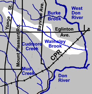
Walmsley Brook (named for John Walmsley, a settler in the Leaside area) started as two small streams near Duplex Avenue and Alexandra Boulevard, which joined west of Yonge Street and flowed SW to Mount Pleasant Road and Broadway Ave. From there it flowed in a generally easterly direction past the corner Bayview Avenue and Eglinton Avenue to meet the West Don River in Ernest Thompson Seton Park, just north of Overlea Boulevard. It was approximately six kilometres long and had one and a half kilometres in two tributaries. Walmsley Brook is divided into three reaches in this account: Broadway Reach, from its source to Bayview Avenue; Leaside Reach, to the CPR Railway; and Power Lines Reach, from the CPR to where it joins the West Don River. Elvina Stream, a small tributary, which joins the Broadway Reach just east of Mount Pleasant Road, and Northlea Stream, joining Leaside Reach, are briefly described.
 

Attachments

  • Grand Opera House 1928 LAC.jpg
    Grand Opera House 1928 LAC.jpg
    520.1 KB · Views: 1,341
  • 11 Adelaide W.jpg
    11 Adelaide W.jpg
    512.2 KB · Views: 1,042
  • Grand_Opera_House_c.1885.jpg
    Grand_Opera_House_c.1885.jpg
    235.8 KB · Views: 969
Last edited:
Grand Opera House, Adelaide St. W. .......1928 ..LAC

The Grand Opera House was supposedly demolished in 1927, so that photo may be earlier than 1928. Interesting photo from the post-Ambrose Small disappearance, when many Torontonians of the day would have viewed this theatre as having a bad reputation.
 
Bay St. at Lakeshore Blvd. ...1928
from Toronto Harbour Commission Administration Building. 1928.jpg


Bay S. of Gardiner 2013.jpg

Image from 2013
 

Attachments

  • from Toronto Harbour Commission Administration Building. 1928.jpg
    from Toronto Harbour Commission Administration Building. 1928.jpg
    345 KB · Views: 943
  • Bay S. of Gardiner 2013.jpg
    Bay S. of Gardiner 2013.jpg
    413 KB · Views: 1,036
Last edited:
Bay St. at Lakeshore Blvd. ...1928
Interesting that Yonge seems to have ended at Front or The Esplanade. (The area at the Toronto Wholesale Fruit Market : formerly the Great Western Railway Co. of Canada terminal, is shown here, it can be seen in Goldie's photo and was at north-east corner of Yonge and The Esplanade, where the L-Tower now is.

yonge-sewer 1928.jpg
 

Attachments

  • yonge-sewer 1928.jpg
    yonge-sewer 1928.jpg
    143.9 KB · Views: 1,362
Interesting that Yonge seems to have ended at Front or The Esplanade. (The area at the Toronto Wholesale Fruit Market : formerly the Great Western Railway Co. of Canada terminal, is shown here, it can be seen in Goldie's photo and was at north-east corner of Yonge and The Esplanade, where the L-Tower now is.

View attachment 140230

Yes DSC........ Yonge St. ended just S. of the Esplanade and RR tracks.
The waterfront and wharfs were at the end of Yonge as can be seen in this 1903 image (looking S. on Yonge from Front).
TN Yonge St. towards wharf from Front 1903.jpg
 

Attachments

  • TN Yonge St. towards wharf from Front 1903.jpg
    TN Yonge St. towards wharf from Front 1903.jpg
    341.2 KB · Views: 1,466
Toronto Postal Delivery Building (built 1941) ……photo 1944
Toronto Postal Delivery Building 1944.jpg


Postal building and Royal York barely visible in this 2013 photo.
With a new addition (1999), the Postal Bldg. became Air Canada Centre and will soon be named (July 1, 2018), Scotiabank Arena.
old postal-ACC 2013.jpg
 

Attachments

  • Toronto Postal Delivery Building 1944.jpg
    Toronto Postal Delivery Building 1944.jpg
    209.5 KB · Views: 1,734
  • old postal-ACC 2013.jpg
    old postal-ACC 2013.jpg
    350.3 KB · Views: 1,438
Last edited:
The Grand Opera House was supposedly demolished in 1927, so that photo may be earlier than 1928. Interesting photo from the post-Ambrose Small disappearance, when many Torontonians of the day would have viewed this theatre as having a bad reputation.

And to those confused by the modern photos, the Wood Gundy façade was moved from King to Adelaide on behalf of Scotia Plaza in the 80s.
 

Back
Top