4.1K
4.1K 


Next week, the City of Toronto's Executive Committee will consider a City staff report recommending the next steps for two linked projects; SmartTrack, and the westward extension of the Crosstown LRT.
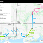
Readers will remember Smart Track. When Mayor John Tory was merely mayoral candidate Tory, a chief plank of his campaign platform was his proposal for above-ground rapid transit service mostly along two GO Transit rail corridors through the city. One component of the plan would have resulted in heavy-rail trains operating along Eglinton Avenue West from Mount Dennis at the end of the Crosstown LRT line to the Airport Corporate Centre in Mississauga, and, possibly, Toronto Pearson International Airport.
 Candidate Tory's original plan for SmartTrack, image, John Tory campaign
Well, now that Tory is mayor, the SmartTrack plan is still around. Just last month, the City and Metrolinx hosted public meetings on the proposals. Eglinton West is no longer part of the heavy rail scheme: in early 2016, the City of Toronto's Chief Planner Jennifer Keesmaat released a report that recommended to City Council that it support light rail transit along Eglinton west of Weston Road.
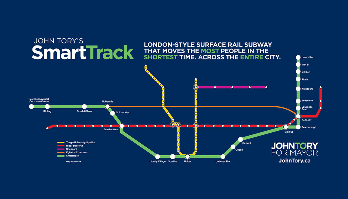
Council endorsed the report's recommendations, effectively short-turning SmartTrack at Mount Dennis and re-affirming a proposal that was around long before anyone ever thought about SmartTrack—extending the Crosstown LRT further west along Eglinton. Ontario's Minister of the Environment had already approved the plan for the extension in 2010 as part of an earlier environmental assessment process.
 In 2010, Ontario's Minister of the Environment approved this plan for the Eglinton West line, image, City of Toronto
Toronto City Council had asked the chief planner to review various options for building this western leg of the proposed line. Her team hired HDR Inc. to analyze several variations for routes that would have resulted in a line on Eglinton Avenue. The group also looked at options that would have continued the line further north along the GO corridor, and then toward the airport before reaching the Mississauga airport business area.
The outcome? All heavy-rail proposals would negatively impact the local community. And, all would cost significantly more—but attract significantly fewer riders—than light rail.
Since then, City, TTC and Metrolinx staff have been re-examining the original 2010 proposal. Metrolinx is also working with government and transit partners, including the City of Mississauga and the Greater Toronto Airports Authority, to determine the best route for the LRT between Commerce Boulevard and a future Pearson regional transit centre.
The planning team reviewed stop locations and the feasibility, costs, benefits, impacts and strategic value of possible grade separations along the route. Last week, the team hosted community meetings to present their findings. Now, City staff are recommending to Executive that the City work with Metrolinx proceed to a formal environmental assessment process for both projects.
In a recent statement to the press, Mayor John Tory said "Since taking office, we haven’t wasted any time getting on with getting SmartTrack built. SmartTrack was developed from a simple fact: there are major rail corridors that run through the City of Toronto that are not being used to help our residents move around. SmartTrack will give commuters one more option for getting around the city."
According to the release, "SmartTrack will allow Toronto transit riders to take the train in the city. For a TTC fare, commuters will have access to trains every six to ten minutes at fourteen stations throughout the city. The plan will also see the Eglinton Crosstown LRT line extended west from the Mount Dennis transit hub to Pearson Airport with ten or more new stations."
The report to Executive refines the original proposals. Staff had included some of those refinements in the materials that they presented at the recent community meetings. Some of them also emerged from comments that the public provided during those events or through on-line surveys.
For SmartTrack, the City is recommending that it work with Metrolinx to build six new stations along the corridor at
- St. Clair Avenue West / (west of) Old Weston Road
- King Street West / Liberty Village
- East Harbour (the Unilever site)
- Gerrard Street East / Carlaw Avenue
- Lawrence Avenue East / (east of) Kennedy Road
- Finch Avenue East / (east of ) Kennedy
For its regional express rail plan, Metrolinx would build two more GO stations at
- Bloor Street West / Lansdowne Avenue
- Spadina Avenue / Front Street West
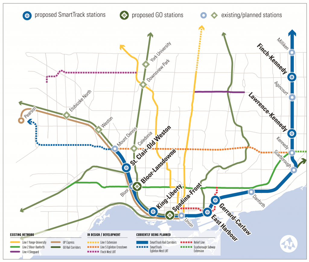 SmartTrack adds six new stations on GO Transit rail lines. Regional express rail requires two more, image, City of Toronto
City staff want these stations to enhance the sense of safety and belonging for transit users. With that goal in mind, they intend to require stations to have a recognizable main entrance and presence on a main street. The report explains, "Main entrances should be important civic places and be seen as part of the public realm. While being recognizable, all entrances must also be respectful of the local context. Integrating station entrances with private development will also improve connectivity and station access to surrounding developments."
Stations would not include much space for parking lots—the City's goal is to maximize the number of transit passengers and encourage commuters to connect to the new stations by frequent bus or streetcar. The report's authors explain, "Commuter parking is only effective during peak commuting times. Access to a parking lot enables some people to choose transit for their daily commute from a station that they can drive to. On the other hand, a station designed around parking facilities is essentially inaccessible once the parking lot is full. It would not be realistic to provide surface parking for all of the riders required to justify investing in the transit infrastructure to begin with.
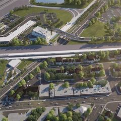
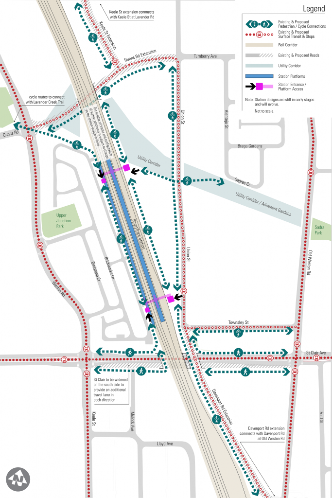 Plan for the future SmartTrack station near St. Clair Avenue West and Old Weston Road, image, City of Toronto
"The cost of providing commuter parking is high. These include ongoing operations and maintenance costs, like snow clearing, cash paid annually to the City in lieu of property tax, capital construction costs and land acquisition. It is estimated that each surface parking spot in Toronto costs around $560/year to operate and maintain."
Similarly, staff are also discouraging Metrolinx from building large passenger pick-up and drop-off facilities (prosaically known as PPUDOs and, more poetically, as "Kiss 'n' Rides.) Although the planners acknowledge that PPUDOs "play an important role for those who have mobility challenges, can be used by taxis and ridesharing services, and can incent some people to use transit that otherwise would not. At the same time, formal PPUDOs are typically very large and use the most important locations, directly adjacent to station entrances. "
Instead, staff want designers to simply include accessible loading and unloading areas for TTC Wheel-Trans and other paratransit providers close to station entrances.
Staff are starting to plan the areas surrounding each of these new stations to make sure that they effectively integrate into current and planned local context and help make sure that the station areas mature in a way that supports the significant public investment in improving rapid transit.
Each of the new stations, in turn, complements other planning studies related to the nearby district or the local transportation network.
Last July, when Council endorsed reviving light rail transit along Eglinton West, it asked staff to re-examine the design of the 2010 proposal. It wanted them to review the number of stops and to address the concerns of local councillors and residents about how the line would impact traffic on Eglinton.
By last November, the design team had determined that some of the stops proposed in 2010 were unlikely to attract many passengers or any future development. The team recommended that Council approve dropping them from the line. That removed station stops at Russell Road / Eden Valley Drive, The East Mall, Rangoon Road and Renforth Drive from the plan. (Both the original and the current proposal continue to list an LRT stop beside the Renforth Station on the Mississauga Transitway–but that station is, in fact well to the west of Renforth Drive at Commerce Boulevard.)
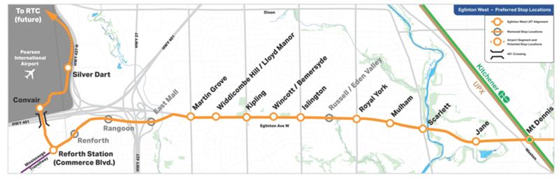 Staff have recommended dropping some of the stations that were originally proposed, image, City of Toronto
To reduce the traffic impact and calm the fears of nearby residents, staff looked at several possibilities for the future transit line:
- a surface LRT with grade separations (bridges) at Eglinton Flats (Jane and Scarlett), Martin Grove and Kipling;
- a surface LRT with grade separations at all arterial roads;
- a fully grade-separated (meaning: above-ground or underground) LRT with six stops total (just three in Toronto); or
- a surface bus rapid transit line.
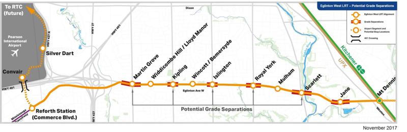 Council directed staff to include grade separations at major arterial roads, image, City of Toronto
Due to soil conditions and other factors, staff assessed above-ground structures at Jane Street, Scarlett Road and Islington Avenue and below-ground at Royal York Road, Kipling Avenue and Martin Grove Road. The structures would also intrude on part of the the Humber River Valley, crossing on the north side of the Eglinton right-of-way. All other grade separations would be in the centre of the roadway.
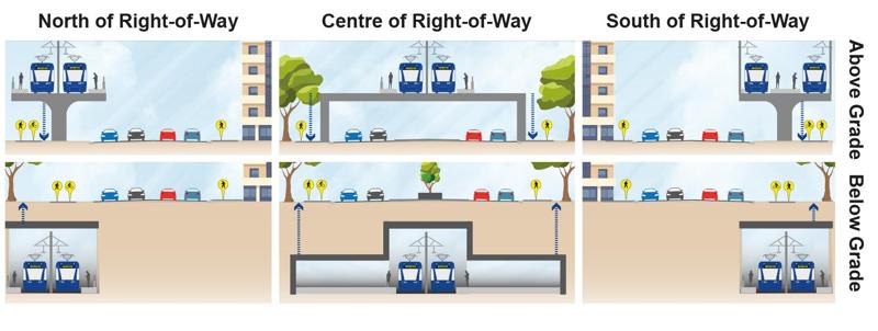 Staff examined various types of grade separations to carry the LRT over or under cross-streets, image, City of Toronto
After examining the various bridge scenarios, staff decided to recommend that the City not proceed with any of this extra infrastructure. They've determined that building stations above or below ground significantly decreases the accessibility of the stops, particularly for passengers using mobility devices. Overhead bridges would also obscure sightlines for motorists driving north and south along cross streets and would definitely visually obstruct the vista over the Humber Valley. Moreover, the added cost of building the grade separations far outweighs any benefits to passengers. Since LRTs can control traffic signals—effectively halting traffic on cross-streets—building grade separations would make no difference to the speed of future LRT train-sets passing along Eglinton West.
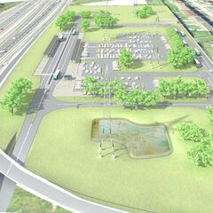
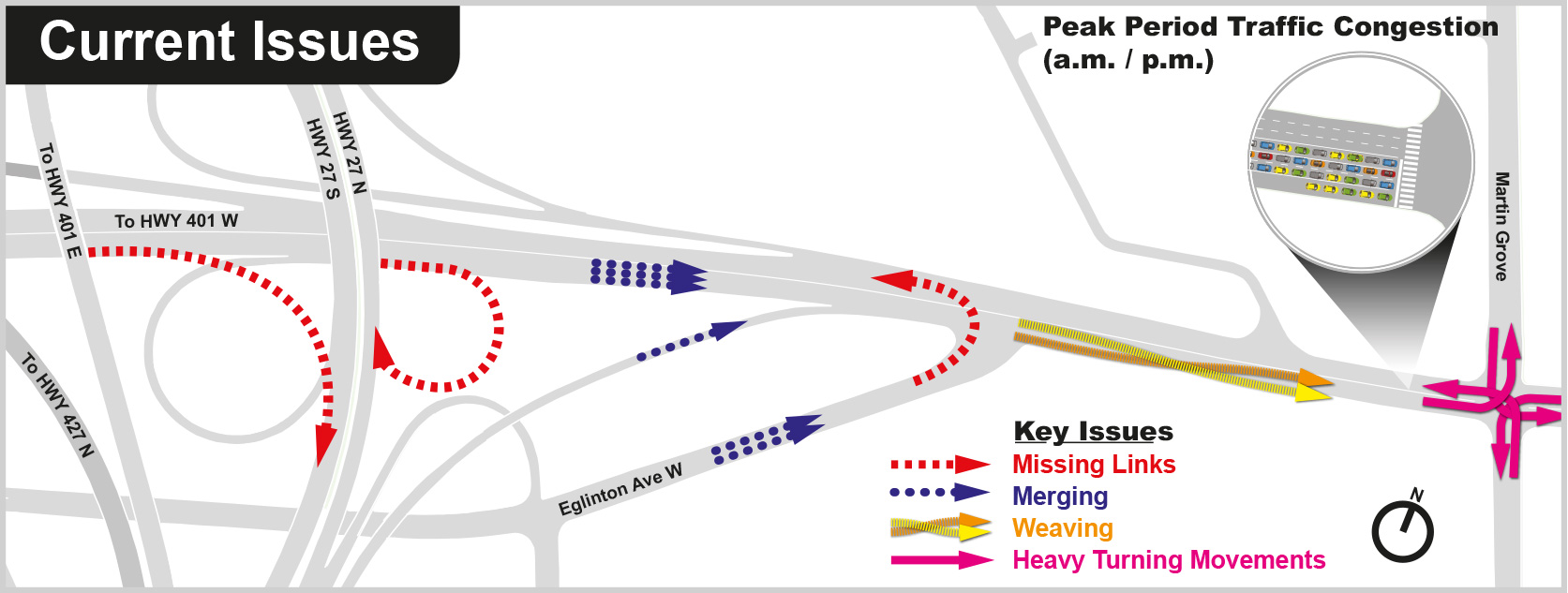 Staff will study traffic conditions at Martin Grove Road before finalizing the LRT stop location, image, City of Toronto
The team will also study traffic conditions at Eglinton and Martin Grove where traffic from Highway 401 and 427 pour across the intersection.
So, the team is now recommending a centre-road, surface only, LRT between Mount Dennis and the Renforth Transitway Station on Commerce Boulevard with just 10 stops. The City / Metrolinx team is also continuing to work with its partners to plan the line beyond Renforth, across Highway 401 to the airport and the future regional transit terminal there.
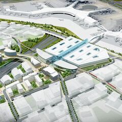
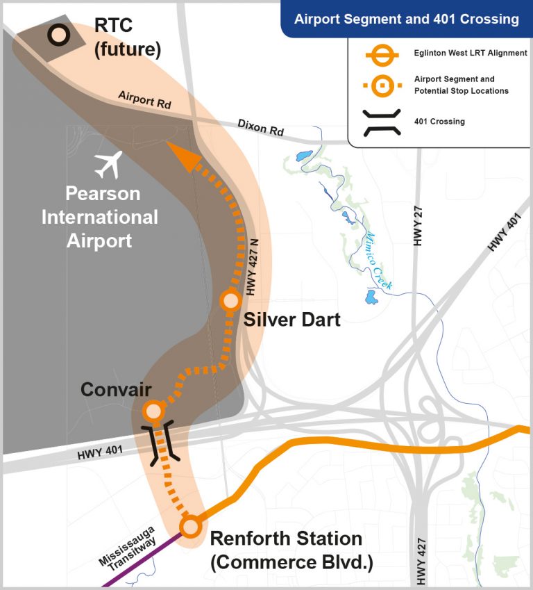 The City, Metrolinx and its partners are still reviewing a link between Renforth and Pearson, image, City of Toronto
The Executive Committee will consider the report during its meeting November 28. If the committee approves the report, City Council likely discusses its recommendations December 5, 6 and 7.
If Council endorses the main recommendations of the report, the City and Metrolinx will proceed to finalize the design and start the formal transit project assessment process.
We will continue to update you on the progress of the projects. In the meantime, you can also join the discussion by visiting our associated forum thread, or by leaving a comment in the space provided on this page.
| Related Companies: | Arcadis, Doka Canada Ltd./Ltee, LiveRoof Ontario Inc, Precise ParkLink, Urban Strategies Inc. |