News   Jul 19, 2024
 920     0 
News   Jul 19, 2024
 3.9K     7 
News   Jul 19, 2024
 1.2K     4 

Will Liberty Village get its much-needed new street?

AlbertC

Superstar
Member Bio
Joined
Apr 24, 2007
Messages
22,684
Reaction score
61,791
Location
Davenport
http://www.thegridto.com/city/local...lage-get-its-much-needed-new-street/?mid=5432

Will Liberty Village get its much-needed new street?

Residents in congested neighbourhood are invited to a second, City-hosted open-house consultation today to review plans for a new east-west traffic artery.
BY: MONIKA WARZECHA

THU DEC 1, 2011


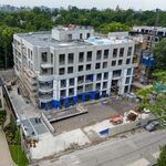
After undertaking a workshop and public consultation earlier this year, Liberty Village is inching closer to creating a plan for a new street in the southern part of the neighbourhood. The proposed east-west road would run between Dufferin and Strachan, above the Hamilton GO Train tracks north of the Gardiner. A second open house will be held today from 4:30-8 p.m. at the Tenant’s Lounge in the Liberty Market building (171 East Liberty St.).

The narrow streets are seen as part of the neighbourhood’s charm, a quirk that helps Liberty Village feel like, well, a village. But the cul-de-sacs that run north-south in the area end right before the railway tracks north of the Gardiner, leaving Liberty/East Liberty Street as the only east-west throughfare in the neighbourhood.

Throw in a condo boom on the eastern part of the neighbourhood, some 6,000 office-workers in the western flank’s employment zone and transport trucks trying to get to the Canada Bread plant on Fraser, and you get major traffic problems at the East Liberty and Strachan, and Dufferin and Liberty intersections.

The proposed plan would connect the north-south dead-end streets with a new east-west street just north of the Hamilton line railway corridor. Right now, that space is filled with a number of billboard footings, though a few buildings jut onto the land.

The preferred design for the new street would better connect north-south streets (Mowat, Fraser, Pardee, Jefferson, Atlantic, Hanna) to Dufferin Street. Though many hoped the new road would connect to Strachan, a Telus Tower block and GO Transit infrastructure make that a huge challenge.

“Liberty Village has gone through a premature Soho effect, where the rents went up so high in anticipation of all the wonderful things that were going to happen, that never really happened,†he says.

“So a lot of the artists and the people that used to live here have long since left because of the rent, but none of those things that those high rents were predicated on have happened, like the Front Street extension.â€

Armstrong would love to see a downtown relief line built or for the City to run subway-like trains on the nearby rail tracks. But with the congestion problems as they are now and a new transit line suddenly popping up along the city’s southern unlikely, he doesn’t think Liberty Village can become more than it is now if this new street isn’t built.

“Property owners have been telling the BIA that they’re having trouble landing large tenants because people just won’t move into the neighbourhood because they can’t get in and out,†he says.

“We’ve reached a plateau. And we’ll never get past this plateau and never flly bloom unless we do something.â€
 
In the same idea of thinking, I wonder what the feasibility of a pedestrian connection over the rail corridor at Shaw would be?
 
I thought this Front Street extension was planned for years already, but all the way to Bathurst, not just ending at Strachan.
 
I thought this Front Street extension was planned for years already, but all the way to Bathurst, not just ending at Strachan.

The Front Street Extension had been talked about for decades. Then was funded and anounced in our last Olympic bid. Chretien, Harris and Lastman had a press conference announcing projects that were being fully funded and would be completed prior to the 2008 Olympics and that this promise was regardless of whether we actually won the olympics. One project (the second subway platform at Union) eventually got started but had no chance of being completed before the Olympics (since they did not start it until after the Olympics)...one I am not sure where we are at on it (cleaning up the mouth of the Don) and one was cancelled by Mayor Miller (so for people who like to jump on Rob Ford for cancelling projects that were fully funded.....consider this one!).

The plan, then, was to extend Front St. west from its current terminus at Bathurst....taking it westward to just west of Dufferin where a bridges would allow the road to merge with the Gardiner.
 
Last edited:
I thought this Front Street extension was planned for years already, but all the way to Bathurst, not just ending at Strachan.
Though it wasn't so much a city street, but a highway on ramp from the Gardiner to Bathurst.
 
Here is how is was described by the city:

http://www.toronto.ca/waterfront/front_extension.htm said:
The Front Street Extension has been a component of the transportation plan for the central core of the City of Toronto for nearly 20 years. The extension was first proposed as part of the Central Waterfront Transportation Study, conducted in 1983. The need for the extension was confirmed in two further studies, the Railway Lands Transportation Review (1995) and the Central Area Transportation Review, conducted in 1996. All of these studies indicated that the transportation network serving the downtown from the west was approaching capacity and that improvements were required to serve the ongoing and planned new development proposed in the waterfront and railway lands areas.

A two-kilometre extension of Front Street from its current terminus west from Bathurst Street to Dufferin Street, including connections to and from the Gardiner Expressway in the vicinity of Exhibition Place, will provide a new direct entrance into the downtown from the west. The Front Street Extension will also provide new access to the emerging development areas located between Dufferin and Bathurst Streets north of the railway corridor.

The Front Street Extension will increase the flexibility of the downtown transportation network to accommodate existing and future demands.

The capital project will be overseen by Waterfront Toronto and managed by the City of Toronto.

There is also a map at that page.
 
IIRC The Front Street Extension funding was transferred over to the East Gardiner project. That project is dead now too, at least as far as I can tell. So what happened to the money?
 
I know some people were concerned that Front St would become a highway west of Bathurst St. Then why not just make Front St more narrower west of Bathurst St? Like King/Queen St. Such streets always are more attractive for the neighbourhoods and retail, etc
 
The irony (IMO) is that it was residents who rallied to kill the Front Street extension (as opposed to making it less highway-like and reaching a compromise) and now it appears it is the residents of the area calling for a new east-west route that makes it easier for them to get in and out of their neighbourhood.

Perhaps it can be revived in some form.

Based on what taking place in the rail corridor now, you will have to go with an suspension or an cantilever bridge since there cannot be any center support. You could go with a truss bridge also.

I have no problem with one if it is only a single lane for traffic with a transit and bike lane as well with nice wide sidewalk. It will be only for the local residents, not the thought traffic that will show up on day one if any road is built for the area.

That what you get for not decreasing the number of cars for all that new development.

Bottom line, prefer not to see this road built, as it will only add more traffic to the area.
 
I was hoping for some accommodation for a future transit service. This whole project seems designed to relieve traffic in liberty village, but it still dumps all the cars onto Strachan (maybe) and Dufferin. Why not also think about relieving the pressure on the King Streetcar? It seems like transit along Front St. will become a necessity soon, if it isnt already. There's an opportunity with this project, and the reconfiguration of Front St. between York and Bay to establish a partial ROW for a future Front Streetcar service, potentially as an alignment for the Waterfront West 'LRT'. Its pretty ridiculous to have no east-west route between King and Queens Quay, considering the massive development happening in that tract.
 
I was hoping for some accommodation for a future transit service. This whole project seems designed to relieve traffic in liberty village, but it still dumps all the cars onto Strachan (maybe) and Dufferin. Why not also think about relieving the pressure on the King Streetcar? It seems like transit along Front St. will become a necessity soon, if it isnt already. There's an opportunity with this project, and the reconfiguration of Front St. between York and Bay to establish a partial ROW for a future Front Streetcar service, potentially as an alignment for the Waterfront West 'LRT'. Its pretty ridiculous to have no east-west route between King and Queens Quay, considering the massive development happening in that tract.

There is a need for an east west route. I cannot believe residents could not come to a compromise. I think King is two lanes in each direction so I think two lanes in each direction would work for Front. Then separated bike lanes would be nice on Front to. Or if there will be a ROW streetcar, then you will still need 2 lanes in each direction which would go down to 1 lane with the other lane for parking outside of rush hours like on St. Clair and then the streetcar. If Front gets the DRL then no need for streetcar, perhaps then 2 lanes for cars plus an additional 1 lane for parking and then still have separated bike lanes also. On Danforth which is a wide street it has 2 lanes of traffic on each side and then there is still another lane for parking. The cars are not speeding on there. Plus the sidewalks are wide also. The speed limit needs to be 50kms and no more. If you make it 60kms, it is too fast. And there is a difference walking on a street where cars are going 60 vs 50. I live near Keele St south of Lawrence which has 60kms in certain parts and it is fast. I find on St. Clair because of the streetcar and the parking, most times I am going less than 50kms also.

What is the Waterfront LRt? Is this the same as the Queens Quay LRT?
 
Last edited:
What is the Waterfront LRt? Is this the same as the Queens Quay LRT?

It's gone through various permutations, but most recently it was lumped together with Transit City. The basic idea is to build a connection between the Queensway ROW and the Fleet/Queen's Quay ROW (or, more recently, a new ROW on Bremner), thus providing a much faster route into the core from the western waterfront, as well as a new east-west link for Liberty Village and CityPlace. A streetcar coming from Long Branch would then be in ROW from the Queensway all the way to Union. The new part of the line would follow the railway or the Gardiner with fairly wide stop spacing, which, together with the ROW, would make it way faster than the 501 or 504.

http://en.wikipedia.org/wiki/Waterfront_West_LRT
 
But how does it provide a link for Liberty Village. Is Liberty Village not situated around Front St and north.
 

Back
Top