


Napoleon
Active Member
Streetcar routes down Dundas, Dovercourt & Ossington? That's a little bit overkill. Even Ossington is probably a little light on the ridership for a streetcar route.
|
|
|
I like the fact that the streetcar routes are not too long, ending at Eglinton to the north. That is the issue with Melbourne, a city that did keep its historic streetcar network and never stopped expanding it. Their streetcar routes reach well into their suburbs and are waaay too long and inefficient for those kind of commutes.
Streetcar down Mt Pleasant Jarvis eh? Parts of the route are very highway-like: fast, winding and hilly. Still hoping for a bus route there (that doesn't cost extra and runs all day).
Streetcar routes down Dundas, Dovercourt & Ossington? That's a little bit overkill. Even Ossington is probably a little light on the ridership for a streetcar route.
Streetcar routes down Dundas, Dovercourt & Ossington? That's a little bit overkill. Even Ossington is probably a little light on the ridership for a streetcar route.
Lucky you not to be a regular user of the Ossington busI'm not a frequent user of the Ossington bus, however it is part of the TTC's frequent bus network and connects to the growing Liberty Village area, so I would imagine that ridership must be pretty good (or at least south of Bloor).
")
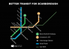
I'm curious to see what our future transit map would look like fully incorporating the Spadina extension and the Tory expansion plan:
No doubt line 5 will look super long, especially with all the stops on the surface sections.
- Crosstown Line 5 from Pearson to UTSC
- Finch West Line 6 from Finch West Station to Humber
- Smart Track from Mount Dennis to Kennedy
- One-stop Line 2 extension to STC
Someone on reddit posted a question in similar vain to your post, so I will copy+paste what I wrote:It's still surprising to see a transit line (Eglinton) with stations farther apart in the dense areas and very close at the less dense areas.
Someone on reddit posted a question in similar vain to your post, so I will copy+paste what I wrote:
You are underestimating how big Scarborough is. Even with that many stops, the stop spacing is going to be well over 400-500 meters. (e.g. I thought the Mason Rd stop was useless, but it is actually 455 meters from Eglinton GO to the west and 530 meters from Markham Rd to the east)
For reference, that is stop spacing not too dissimilar to the Bloor-Danforth line (which are typically ~400-500 meters). The problematic St. Clair and Spadina streetcars have stops every 100 meters.
Also, consider if we remove too many stops we might be required to run an infrequent bus route along the same corridor, just to intercept local stops. That being said, I think a few stops could and should be cut.
I'm curious to see what our future transit map would look like fully incorporating the Spadina extension and the Tory expansion plan:
No doubt line 5 will look super long, especially with all the stops on the surface sections.
- Crosstown Line 5 from Pearson to UTSC
- Finch West Line 6 from Finch West Station to Humber
- Smart Track from Mount Dennis to Kennedy
- One-stop Line 2 extension to STC
Half of the Scarborough stops are unnecessary. Lebovic's too close too Warden. Ionview too close to Birchmount. Midland too close to Kennedy Stn. McCowan too close to Bellamy/Eglinton GO. Mason too close to Markham Rd. Both Kingston/Eglinton and Guildwood Pkwy are too close to Scarb. Golf Club. Stops at both Lawrence and Morningside is overkill, one stop straddling both would suffice. Beath would see maybe 50 users per day off-peak. Building larger stations with secondary exits would eliminate the need for having to stop every 500 metres. Scarborough isn't south-of-Bloor dense. Consider the added runtime serving all those miscellaneous stops would cause.