ShonTron
Moderator
Member Bio
- Joined
- Apr 24, 2007
- Messages
- 12,425
- Reaction score
- 9,140
- Location
- Ward 13 - Toronto Centre
Have fun taking the T after a Red Sox game at Fenway!
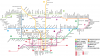
Yeah, Boston's rapid transit is a bit of a joke, considering how busy it should be. They like moving transit around more than actually building more of it; the Orange Line used to operate on an elevated over Washington Boulevard before being moved to a trench to the west. The original Silver Line BRT (more like a BRT lite) operates over the old Elevated route. There are abandoned sections of the Green Line - which is why there's no "A" Branch on the maps and why the "E" line ends at Heath, but abandoned tracks continue south to Forest Hills.
Yeah, Boston's rapid transit is a bit of a joke, considering how busy it should be. They like moving transit around more than actually building more of it; the Orange Line used to operate on an elevated over Washington Boulevard before being moved to a trench to the west. The original Silver Line BRT (more like a BRT lite) operates over the old Elevated route. There are abandoned sections of the Green Line - which is why there's no "A" Branch on the maps and why the "E" line ends at Heath, but abandoned tracks continue south to Forest Hills.